
Exploration on statistical methods for analyzing correlations between rainfall and sediment discharge in base period by hydrologic method in the Xinshui River Basin, Shanxi Province of northern China
-
摘要:目的 基于昕水河流域日尺度降雨和输沙数据,分析1958—2015年昕水河流域降水与输沙变化趋势及相关关系,比较年降雨量、汛期降雨量、侵蚀性降雨量、轻度产沙降雨量、中度产沙降雨量、强度产沙降雨量等6种统计标准和降水空间分布对“水文法”基准期分析降水输沙相关关系的影响,筛选最佳的降水输沙相关关系统计方法,提高“水文法”的计算精度。方法 利用Mann-Kendall非参数检验方法分析降水量与输沙量变化趋势,双累积曲线法判定“水文法”基准期,Pearson相关分析法比较水沙关系相关性结果。结果 昕水河流域年降水量无显著变化趋势,年输沙量呈显著下降趋势;6种统计标准下的水沙关系相关性由高至低依次为:强度产沙降雨量、年降雨量、侵蚀性降雨量、中度产沙降雨量、轻度产沙降雨量、汛期降雨量;低降雨强度但高降雨量降雨事件对研究区产沙贡献小,剔除产沙无效降雨能提高水沙关系相关性;午城、黄土、蒲县雨量站水沙关系相关性较好,大宁、桑峨雨量站水沙关系相关性较差。结论 昕水河流域年输沙量变化与三北防护林及淤地坝建设等地表人类活动变化直接相关;研究区的产沙主要发生在夏秋季的强降雨事件中,强度产沙降雨量用于降水输沙相关关系研究结果最优,汛期降雨量不适用于降水输沙相关关系研究,产沙无效降雨会增加水沙关系研究的偏差,在缺乏降雨强度准确数据时,应选择降雨历时短、降雨量大的产沙有效降雨进行水沙关系分析;在流域尺度,降水空间分布对降水输沙相关关系有影响,距流域出口站距离较近雨量站降水数据的水沙相关关系较好。Abstract:Objective This paper analyzes the trend and relationship between rainfall and sediment discharge in the Xinshui River Basin in Shanxi Province of northern China from 1958 to 2015 based on the daily rainfall and sediment discharge data, aiming to select the best statistical method according to the effects of rainfall spatial distribution and six statistical criteria of rainfall on calculating the relationship between rainfall and sediment discharge used for the “hydrologic method” in base period. The six statistical criteria of rainfall included the annual rainfall, the flood season rainfall, the erosion rainfall, the mild sand-producing rainfall, the moderate sand-producing rainfall and the heavy sand-producing rainfall.Method Mann-Kendall method was selected to analyze the trend of rainfall and sediment discharge, double mass curve was applied to determine the base period of “hydrologic method”, and Pearson correlation analysis was used to compare the results of correlation between rainfall and sediment discharge.Result There was no significant changing trend of annual rainfall in Xinshui River Basin, but the annual sediment yield showed a significant decreasing trend. The Pearson correlation coefficients between rainfall and sediment yield under the six statistical standards were ordered from high to low as follows: the heavy sand-producing rainfall, annual rainfall, the erosion rainfall, the moderate sand-producing rainfall, the mild sand-producing rainfall and flood season rainfall. The contribution of rainfall with low intensity but high amount on sediment was small. The correlation coefficient between rainfall and sediment yield can be enhanced by eliminating the invalid rainfall for sediment. The correlation coefficients between rainfall and sediment discharge of Wucheng, Huangtu, and Puxian rainfall stations were higher, and the results of Daning, Sang’e rainfall stations were lower.Conclusion The change of annual sediment yield is directly related to the human activities such as the Three North Protection Forest Project and the construction of check dams. Sediment discharge is mainly caused by heavy rainstorm in summer and autumn. The heavy sand-producing rainfall can be used to analyze the relationship between rainfall and sediment discharge, and the flood season rainfall is not suitable for the analysis of the relationship between rainfall and sediment discharge. Invalid rainfall for sediment will increase the deviation of the correlation coefficient between rainfall and sediment discharge. Rainfall with short time duration and high amount should be selected to analyze the correlation coefficient between rainfall and sediment discharge when rainfall intensity data are scarce. The relationship between rainfall and sediment discharge is influenced by the spatial distribution of rainfall stations at the watershed scale.
-
氮是地球上生物体的基本元素,也是陆地生态系统限制植物生长的必要元素[1]。随着气候变化,植物可利用的氮正在减少,因此氮对控制陆地生态系统初级生产力起着关键作用[2]。土壤氮循环过程主要包括土壤氮的矿化和固定,硝化和反硝化作用等。其中,土壤氮矿化指的是土壤氮库中的有机氮在微生物作用下转化为植物和微生物可直接吸收的无机氮[3]。土壤氮矿化速率及其潜力直接影响土壤氮的有效性和供氮能力,对维持草地生态系统组成、结构与功能十分重要[4−5]。草地土壤微生物介导的氮转化过程不仅受到土壤物理和化学等非生物因子的影响,同时还受到生物因子的共同调控。土壤氮含量、形态及不同形态比例是影响土壤氮转化过程的主要限制因子,其中总氮矿化速率与土壤全氮含量呈正相关,而与土壤碳氮比呈负相关 [6−8]。土壤温度和湿度是影响氮矿化的两个重要因素,氮矿化量随着温度和湿度的增加而呈上升趋势[9]。土壤微生物对土壤氮矿化和固持均发挥了重要作用,进而影响土壤氮的可利用性和植物生长。研究表明,土壤氮矿化和固定与土壤微生物生物量显著相关,同时,微生物对氮矿化和固定受到土壤pH、土壤质地、有机质含量和质量等因素的调控[10−11]。因此,微生物是影响土壤氮转化的重要生物因素。
自20世纪中叶以来,人类活动和气候变化导致过量大气氮沉降显著改变了陆地生态系统生物地球化学循环[12−13]。大气氮沉降通过影响土壤氮矿化来改变土壤氮的有效性。通常,氮沉降一方面通过增加植物叶片和凋落物氮含量,促进凋落物分解[14];另一方面,氮沉降可能降低微生物活性[15],抑制蛋白质的解聚合作用[16],进而减弱氮矿化作用。以往大量研究主要从氮沉降对土壤酸碱性[17]、土壤微生物生物量[18]、土壤氮降解酶[19]以及与土壤氮转化功能基因[20]的关系角度,探究其对土壤氮有效性及其转化过程背后复杂的生态学机制。然而,大部分研究集中在生长季节进行氮添加处理,这并不能完全模拟真实大气氮沉降过程。少数不同季节施氮处理试验表明,冬季和春季施氮能够促进植物能吸收更多氮[21],且春季相比秋季施氮能减少土壤氮损失[22]。但不同季节氮添加对土壤氮矿化的影响仍不明确,亟需更多实证研究探究土壤氮矿化对季节性施氮的响应及其调控机制。
草原是最重要的陆地生态系统之一,全球草原总面积达5.25 × 10⁹ hm2,占陆地总面积的40.5%[23]。温带草原是我国北方重要的生态安全屏障,其中内蒙古温带典型草原是我国面积最大的温带草原[24]。然而,多年来由于盲目开垦、过度放牧等不合理利用,内蒙古草原生态系统面临植物生产力、生物多样性下降和土壤养分元素亏缺等严重生态问题。尽管农业中氮肥和粪肥的使用量逐年增加,以提高食物和饲料供应,但也造成了氮污染问题[25]。相比之下,草原施肥仍处于起步阶段,大规模天然草原施肥尚未普及。由于生态系统类型、施氮方式和试验条件的差异,氮沉降对草地生态系统土壤氮矿化的影响可能有所不同。为解决这些问题,本研究选择内蒙古温带典型草原为研究对象,在不同季节(秋、冬、生长季)设置氮添加野外控制试验,通过测定净氮矿化速率、温度、水分等土壤常规理化指标,拟解决以下科学问题:(1) 不同季节氮添加如何影响土壤无机氮累计矿化量、净氮矿化潜力和净硝化潜力?(2) 土壤氮矿化对季节性氮添加响应的影响因素和驱动机制是什么?
1. 研究区概况与研究方法
1.1 研究区概况
研究样地位于内蒙古锡林浩特草原生态系统定位研究站(43°13′12″ N,116°13′48″ E),海拔1 255 ~ 1 260 m,年均气温1.1 ℃,年均降水量343.5 mm,土壤为简育钙积土和旱成土,植物群落以大针茅(Stipa grandis)、羊草(Leymus chinensis)、西伯利亚羽茅(Achnatherum sibiricum)和冰草(Agropyron cristatum)为主要优势种。实验地在正式试验开始前未施化肥,且当地大气氮沉降量背景值低于1.0 g/(m2·a)(以N计,下同)[26]。
1.2 试验设计与采样
2014年7月,在锡林流域中部选择植被分布均匀的草地,采用随机区组设计设置不同季节氮添加试验。设计3个不同季节氮添加处理分别为秋季(10月下旬)、冬季(1月中旬)和生长季节(5月下旬),以及对照处理。每个处理8个重复,共计32个小区,每个小区面积为4 m × 4 m,小区之间设置1 m宽缓冲带。每种处理每年添加1次固体硝酸铵作为氮肥,添加的纯氮量为10 g/(m2·a),添加方式是将硝酸铵和细沙混合均匀撒施。采用顶盖埋管法[27]测定土壤净氮矿化速率。试验于2020年7月第一次取样,2021年开始(5—10月),每月取样测定一次。在每个小区内埋入3个长15 cm、内径为5 cm的PVC管,深度为土壤表层10 cm。为防止降水造成的淋溶损失,管顶部用透气不透水的滤膜封住。原位培养30 d后取出管内的土壤进行铵态氮和硝态氮的测定。埋管前,在距PVC管20 cm处用直径5 cm的土钻取0 ~ 10 cm的土壤,用于测定初始无机氮含量。根据培养前后无机氮含量差值除以培养时间,计算净氮矿化速率。计算公式如下
Δt=t1−t0 ΔCa=Cat1−Cat0 ΔCb=Cbt1−Cbt0 Rmin=ΔCa+ΔCbΔt Rnit=ΔCbΔt Ramm=ΔCaΔt 式中:t0为野外培养开始时间,t1为野外培养结束时间,Δt 为培养前后时间间隔,ΔCa为培养后净铵态氮增加量,ΔCb为培养后净硝态氮增加量,Ca为铵态氮 (mg/kg),Cb为硝态氮(mg/kg),Rmin、Rnit、Ramm分别表示净氮矿化速率 (mg/(kg·d))、净硝化速率 (mg/(kg·d))、净铵化速率 (mg/(kg·d))。
1.3 土壤和植物指标测定
土壤铵态氮和硝态氮用0.5 mol/L氯化钾浸提后,浸提液采用全自动微量流动注射仪(FLASTAR5000,FOSS,Sweden)测定。土壤温度用数字显示温度计测定,土壤水分采用称重法测定。
1.4 数据统计
采用重复测量方差分析(ANCOVA)方法,分析不同季节氮添加对土壤无机氮含量和净氮矿化速率的影响。并采用多元回归模型评价了环境因子和土壤基本理化指标对土壤净氮矿化潜力的影响。所有的统计分析都在R语言软件完成(R Development Core Team,2016)。
2. 结果与分析
2.1 不同季节氮添加对土壤铵态氮、硝态氮和无机氮含量的影响
土壤铵态氮、硝态氮和无机氮含量随不同季节氮添加发生了显著变化(图1)。与对照相比,秋季、冬季和生长季氮添加显著增加了硝态氮和无机氮含量,冬季和生长季氮添加显著提高了铵态氮含量(P < 0.05)。其中,生长季氮添加使铵态氮、硝态氮和无机氮含量增加最多(P < 0.01),分别增加了226.5%、131.8%和172.5%。土壤铵态氮、硝态氮和无机氮对不同季节施氮的响应都表现出明显的月动态变化特征(图1)。2020年7月,生长季氮添加导致铵态氮、硝态氮和无机氮达到最大。次年,不同施氮处理下,铵态氮、硝态氮和无机氮在5、6月份最高,之后呈下降趋势。
![]() 图 1 不同季节氮添加土壤铵态氮、硝态氮和无机氮季节变化的影响不同小写字母表示不同处理间差异显著(P < 0.05),不同大写字母表示不同时间差异显著(P < 0.05)。下同。Different lowercase letters indicate significant difference at P < 0.05 level among varied treatments. Different uppercase letters indicate significant difference at P < 0.05 level among varied times. The same below.Figure 1. Effects of seasonal nitrogen (N) addition on seasonal variations of soil NH+4-N, NO−3-N, and inorganic N concentrations
图 1 不同季节氮添加土壤铵态氮、硝态氮和无机氮季节变化的影响不同小写字母表示不同处理间差异显著(P < 0.05),不同大写字母表示不同时间差异显著(P < 0.05)。下同。Different lowercase letters indicate significant difference at P < 0.05 level among varied treatments. Different uppercase letters indicate significant difference at P < 0.05 level among varied times. The same below.Figure 1. Effects of seasonal nitrogen (N) addition on seasonal variations of soil NH+4-N, NO−3-N, and inorganic N concentrations2.2 不同季节氮添加处理下土壤净氮矿化速率变化特征
通过重复测量方差分析,发现不同季节氮添加处理对净氮矿化速率、净硝化速率、净铵化速率的影响不显著(P > 0.05)。然而,采样时间对氮矿化速率、净硝化速率、净铵化速率的影响显著,同时采样时间和不同季节氮添加处理的交互作用对净氮矿化速率、净硝化速率、净铵化速率也具有显著影响(图2)。
![]() 图 2 不同季节氮添加土壤铵化、硝化和矿化速率季节变化的影响Figure 2. Effects of seasonal N addition on seasonal variations of N ammonification, nitrification and mineralization
图 2 不同季节氮添加土壤铵化、硝化和矿化速率季节变化的影响Figure 2. Effects of seasonal N addition on seasonal variations of N ammonification, nitrification and mineralization不同季节氮添加处理下净铵化速率的月动态变化基本一致,呈现先增加(5—7月)后减少(7—9月)再增加(9—10月)的波浪形趋势(图2a)。其中,净铵化速率在7月份最高,5月和10月份差异显著,而其他月份差异则不显著。净硝化速率在5—6月、7—8月和8—9月最大,这3个月之间差异并不显著,而与6—7月和9—10月具有显著差异(图2b)。2021年净氮矿化速率显著高于2020年,表现出显著的年际差异。净氮矿化速率对不同季节施氮的响应并没有表现出显著的月动态差异。2021年净矿化速率均高于2020年(图2c)。
2.3 土壤氮矿化速率对不同季节氮添加响应的影响因素
土壤氮矿化速率通常会受到环境因素的影响,多元统计分析结果表明(图3),土壤水分和净铵化速率显著负相关(P < 0.05)。温度和降水与净硝化速率分别呈显著负相关和正相关(P < 0.001),且前者与净硝化速率的相关性更大。与净硝化速率相关性基本一致,温度和降水对净氮矿化速率分别表现出显著的负效应(P < 0.01)和正效应(P
< 0.05)。 ![]() 图 3 多元回归模型中的预测变量对净铵化速率(a)、净硝化速率(b)和净氮矿化速率(c)的影响效应量为平均值 ± 标准误。*表示在P < 0.05水平上显著相关;**在P < 0.01水平上显著相关;***在P < 0.001水平上显著相关。Effect sizes are represented as mean ± SE. * means significant correlation at the P < 0.05 level; ** means significant correlation at P < 0.01 level; *** means significant correlation at P < 0.001 level.Figure 3. Effects of predictor variables on net ammonification rate (a), net nitrification rate (b) and net N mineralization rate (c) from multiple regression models
图 3 多元回归模型中的预测变量对净铵化速率(a)、净硝化速率(b)和净氮矿化速率(c)的影响效应量为平均值 ± 标准误。*表示在P < 0.05水平上显著相关;**在P < 0.01水平上显著相关;***在P < 0.001水平上显著相关。Effect sizes are represented as mean ± SE. * means significant correlation at the P < 0.05 level; ** means significant correlation at P < 0.01 level; *** means significant correlation at P < 0.001 level.Figure 3. Effects of predictor variables on net ammonification rate (a), net nitrification rate (b) and net N mineralization rate (c) from multiple regression models3. 讨 论
3.1 不同季节氮添加对土壤无机氮的影响
土壤无机氮含量是地上植物生产力和土壤微生物生物量及其活性的限制因子[5,28]。本研究发现,相比于对照,不同季节性施氮显著促进了土壤无机氮的积累,但无机氮库大小随着试验时间的推移呈下降趋势,这与以往研究结果部分一致[29−31]。其主要原因可能是,无机氮的输入提高了土壤有效氮水平,同时也促进了土壤净硝化作用和净矿化作用[32−33]。大量不同氮水平添加试验结果表明,无机氮含量随施氮浓度的增加而增加[29,34−35],但也有部分研究发现,氮添加对土壤无机氮含量的调控存在饱和阈值[8],这可能与施氮剂量、土壤理化特性和微生物活性等有关。
不同季节施氮条件下,铵态氮和硝态氮含量在5—6月份较高(图1),但从整个生长季来看,铵态氮和硝态氮都呈下降趋势(图1)。这可能是由于实验地的优势物种为羊草,其偏好吸收铵态氮,同时氨挥发和硝化作用等多重过程的影响也导致铵态氮库减少[36]。这与在黄土高原典型草原的研究结果一致[30],可能是因为这两个地方气候环境相似,都是降水较少,植物和微生物一定程度上偏好利用铵态氮[30]。尽管本研究添加的无机氮为硝酸铵,植物氮偏好和微生物固定和硝化过程都需将硝态氮转化成铵盐或铵根来吸收和利用,再加上淋溶等影响从而导致硝态氮库呈下降趋势。从不同季节氮添加影响来看,与秋季和冬季施氮相比,生长季施氮对铵态氮、硝态氮和无机氮库的影响更显著(图1)。这表明,生长季氮添加可能会放大土壤无机氮库对氮沉降的响应。
3.2 不同季节氮添加对土壤氮矿化的影响及其影响因素
氮添加通过改变土壤无机氮库组成、大小和可利用性,进而对土壤矿化作用产生显著促进作用[37−39]。本研究中土壤净铵化速率在2021年5—7月有上升的趋势,这可能是由于气温回升微生物活性增强导致有机氮矿化增加[40]。而在7—10月净铵化速率又呈下降趋势,直接的影响表现为铵态氮含量减少,这可能与植物生长逐渐达到高峰并逐渐减缓,以及在这期间氮固定作用加强有关。土壤净硝化速率在2021年5—7月显著降低,可能是由于这一时期植物处于生长旺盛期,对无机氮尤其是铵态氮需求较高,促使硝态氮部分转化为铵态氮,从而减弱了硝化作用[41−42]。而在8—10月,净硝化速率随氮添加而增加,由于该地区属于半干旱草原气候,而在此时间段降水较多缓解了水分限制,导致硝化作用加强,也反映出该地区在夏秋季氮矿化作用是以硝化作用为主。此前在盐渍化草地和沙质草地的研究结果也分别反映出土壤净氮矿化速率的月和年际动态变化,并且氮矿化速率对氮添加水平的敏感性不同[31,35,41]。
需要注意的是从生长季末期开始(9月)净铵化速率大幅降低,且生长季氮添加的净铵化速率显著低于秋季和冬季施氮,说明无机氮向有机氮转化,生长季施氮促进了该转化过程,这可能与氮添加诱导的生物固持与矿化作用的强弱有关系[43−44]。生长季结束后(10月),净铵化速率逐渐增加,意味着铵固定作用减弱,且生长季施氮相比秋、冬季施氮对净铵化速率的促进作用更大,可能是由于生长季相比秋、冬季氮添加距离生长季末期时间较近,经历完整生长季后存留的微生物依旧会通过矿化有机氮来获取氮(可能主要是铵态氮),这从该时期土壤铵态氮和硝化速率较低也能得以印证。土壤净氮矿化速率和净硝化速率在生长季末期都为正值,意味着该时期已有大量微生物死亡并转化为土壤有机氮;另外尽管同时期铵化速率为负值,一种可能性表明土壤微生物依旧能够矿化利用土壤中微生物残体及其细胞溶解物来获取自身能量和养分物质需求,并促进硝化作用主导的氮矿化过程[45]。生长季氮添加相比于秋、冬季氮添加显著提高了生长季末期净硝化速率和净氮矿化速率,猜测可能是因为生长季施氮使得大量微生物繁殖和生长并矿化有机氮,而生长季末期无法满足土壤存留微生物的生长,迫使异氧微生物对无机氮的矿化和积累[6]。邹亚丽等[30]、徐小惠等[31]、杨仕明等[34]和Corre等[44]在不同生态系统都发现氮添加显著改变了无机氮库、土壤净硝化速率和净矿化速率,并且表现出季节性变化规律,但这些研究施氮时间都在生长季(5—7月),缺乏不同季节氮添加对土壤氮矿化过程和机理的研究,因此今后需加强不同季节施氮对氮矿化影响的研究,以期更好地反映大气氮沉降的真实生态效应。
土壤氮矿化是由生物和非生物因素共同驱动,将土壤有机氮转换为无机氮的生物化学过程。总体而言,温度、水分、氮含量和形态是影响氮沉降和施肥对草原土壤氮转化影响的关键因素[46−48]。其中,温度和降水的季节变化可以直接促进和抑制土壤氮转化[42,49]。在一定范围内,矿化速率随温度上升而增加[9,48],但也有研究发现在温度3 ~ 15 ℃范围内,氮矿化速率并没有受到温度的影响甚至是下降[50−51]。本研究中,温度升高对净硝化速率和净矿化速率表现出负效应,降水增加则表现出正效应(图3)。这可能是由于温度和降水差异导致不同月份之间氮转化对不同季节氮添加的响应有所不同。
4. 结 论
本研究分析了不同季节氮添加对内蒙古温带典型草原土壤净氮矿化速率的影响,得出以下主要结论:不同季节氮添加对土壤铵态氮、硝态氮和无机氮产生了显著影响。其中,与秋季和冬季氮添加相比,生长季氮添加显著增加了无机氮库。土壤无机氮库对不同季节氮添加的响应呈现明显的月动态变化。与无机氮类似,土壤氮矿化速率对不同季节氮添加也表现出明显的月动态特征。净铵化速率、净硝化速率和净氮矿化速率对生长季氮添加的响应最明显。土壤无机氮库和氮矿化对不同季节氮添加的响应差异主要受到温度和降水的影响,而氮添加形式和时间也会影响土壤氮转化过程。因此,未来应重点解析不同季节氮添加对土壤氮转化过程方向、程度、过程及内在机制,这有助于全面了解人为大气氮沉降对陆地生态系统土壤氮循环的影响。
致谢 感谢中国科学院内蒙古草原生态系统定位研究站给予本研究野外工作的支持,感谢陈旭、芦海宁、任正汝、张雨秋、刘若萱、刘丽娟、王晓燕、宋长春和卢炜煜在野外实验数据收集和整理上的帮助。
-
![]()
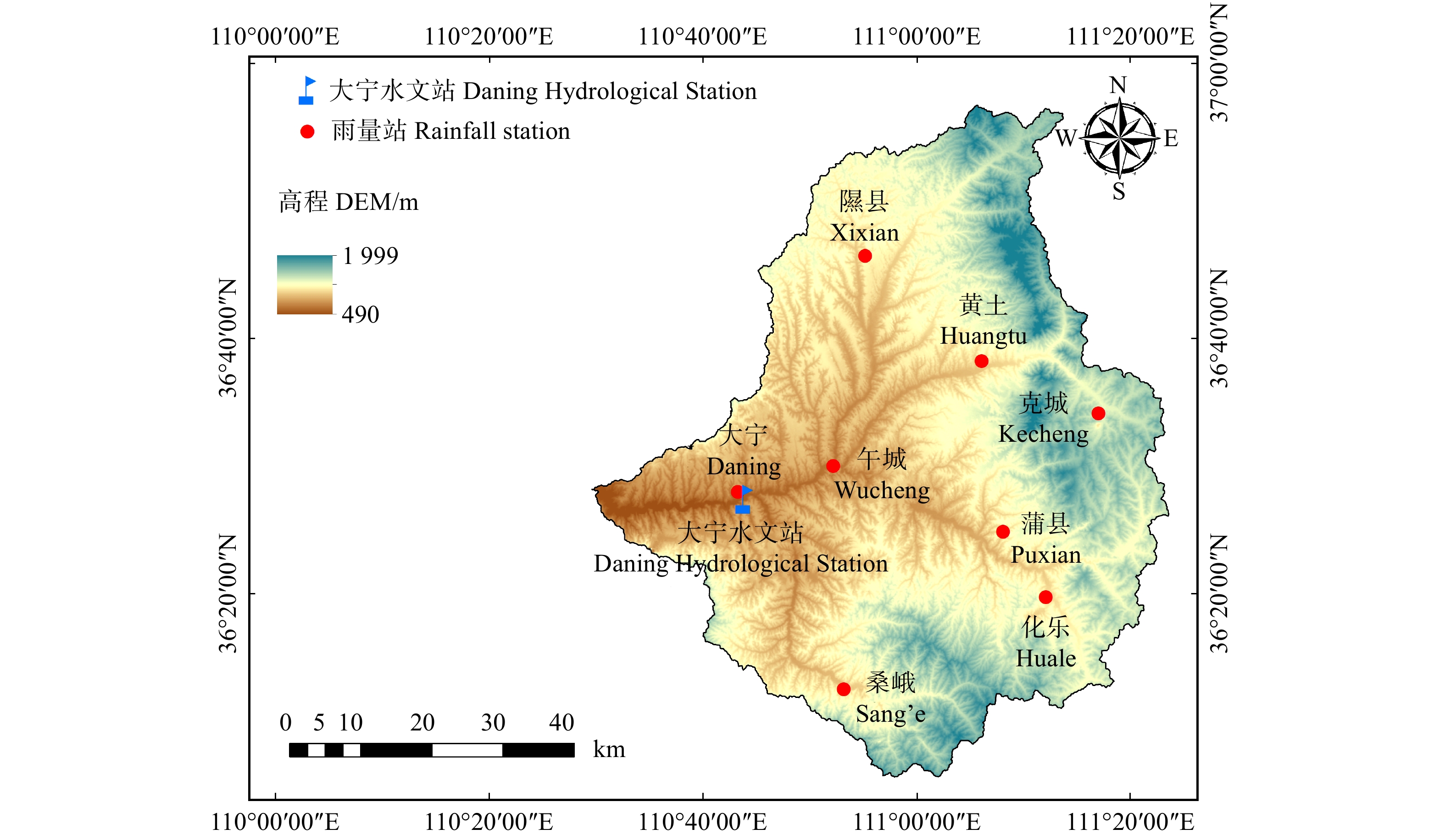
图 1 昕水河流域地理位置、高程及雨量站和水文站点分布
Figure 1. Location and elevation of the Xinshui River Basin and distribution of rainfall stations and hydrological stations
![]()
图 3 1958—2015年昕水河隰县国家气象站年降水量变化
Figure 3. Variation in annual rainfall of Xixian County National Meteorological Station in Xinshui River Basin from 1958 to 2015
![]()
图 4 1958—2015年昕水河隰县国家气象站年降水量变化趋势与突变分析
Figure 4. Mann-Kendall trend tests on annual rainfall at Xixian County National Meteorological Station in Xinshui River Basin from 1958 to 2015
![]()
图 5 1958—2015年昕水河大宁站年输沙量变化
Figure 5. Variation in annual sediment discharge of Daning Hydrological Station in Xinshui River Basin from 1958 to 2015
![]()
图 6 1958—2015年昕水河流域年输沙量变化趋势与突变分析
Figure 6. Mann-Kendall trend tests on annual sediment discharge in Xinshui River Basin from 1958 to 2015
![]()
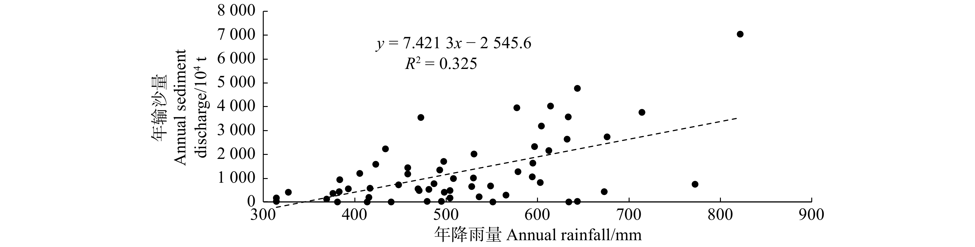
图 7 1958—2015年昕水河年降雨量与年输沙量相关分析
Figure 7. Relationship between annual rainfall and annual sediment discharge in Xinshui River Basin from 1958 to 2015
![]()
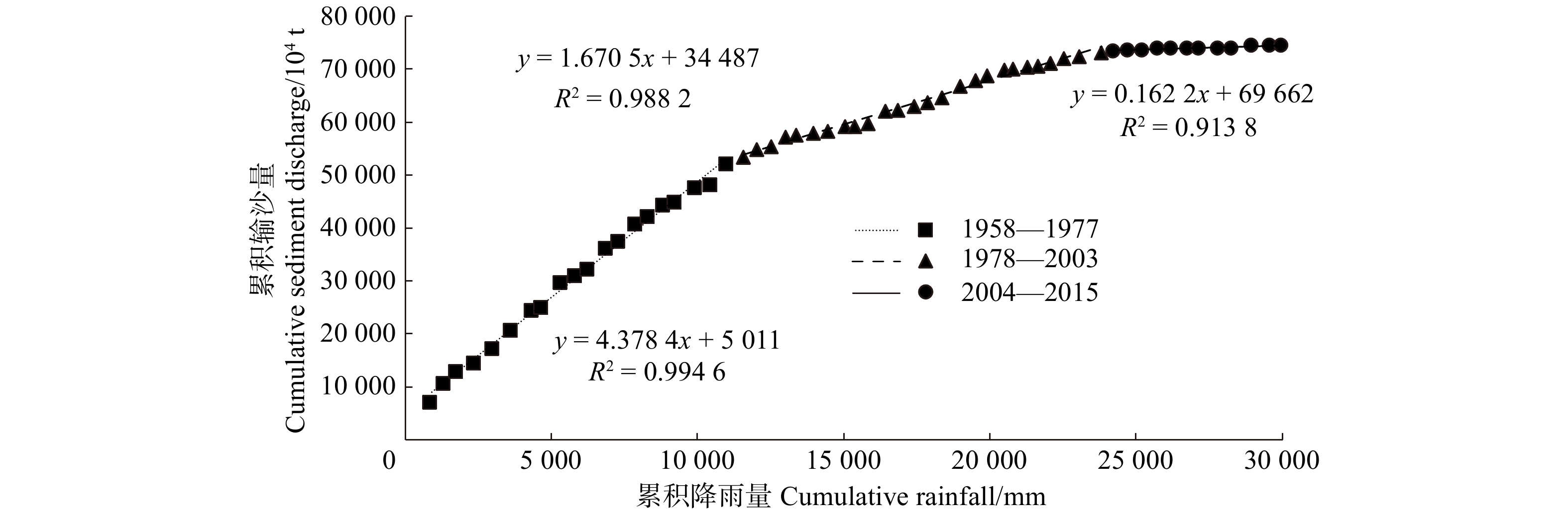
图 8 昕水河流域面平均年降水量与输沙量双累积曲线
Figure 8. Double mass curve of annual rainfall and sediment discharge in Xinshui River Basin
![]()
图 9 昕水河流域骨干、中型淤地坝建成时间及数量图
Figure 9. Completion time and amount chart of large and middle-sized check dams in Xinshui River Basin
![]()
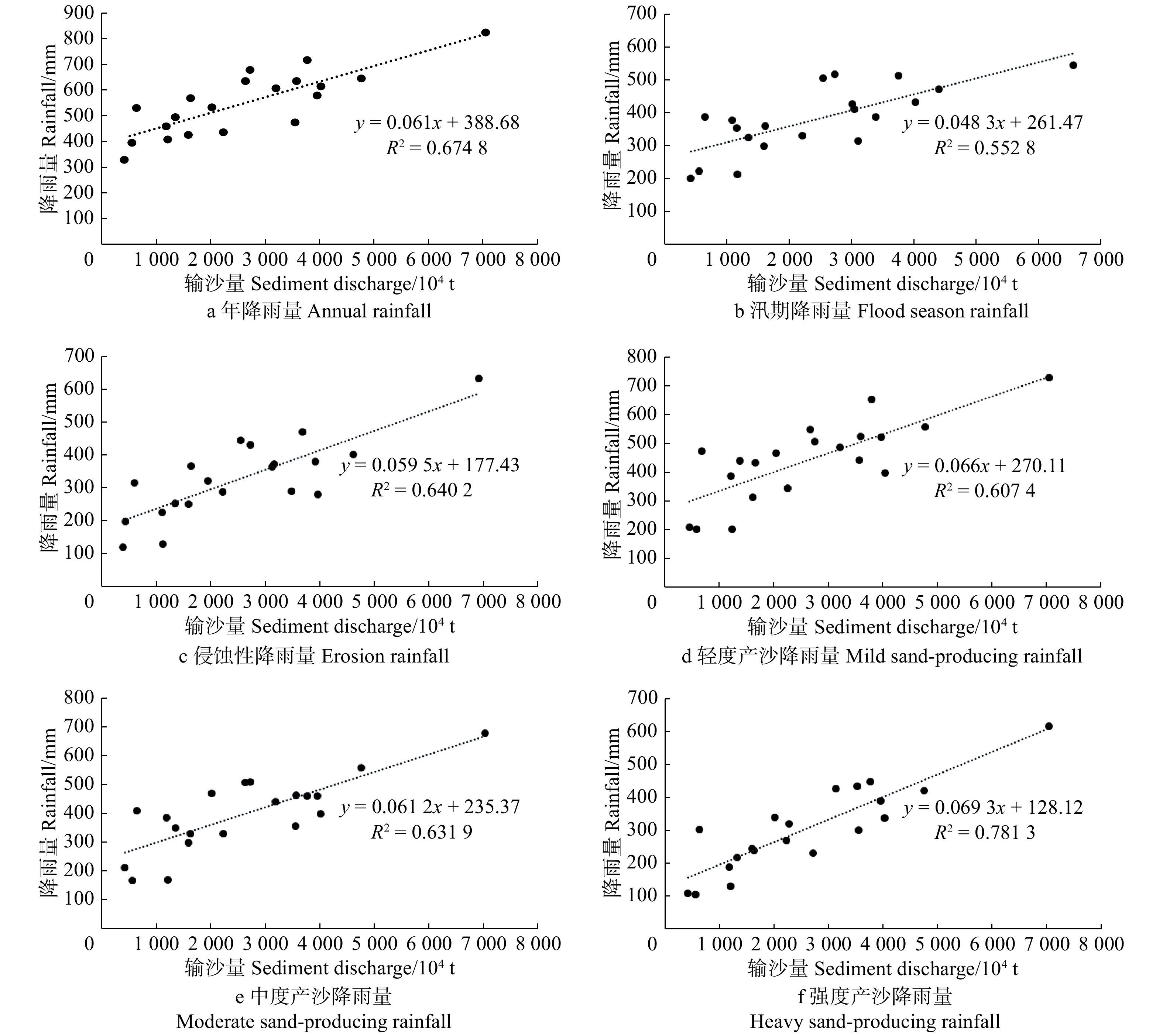
图 10 1958—1977年昕水河流域不同统计标准降水输沙相关关系
Figure 10. Correlations between rainfall and sediment discharge under different statistical standards in Xinshui River Basin from 1958 to 1977
![]()
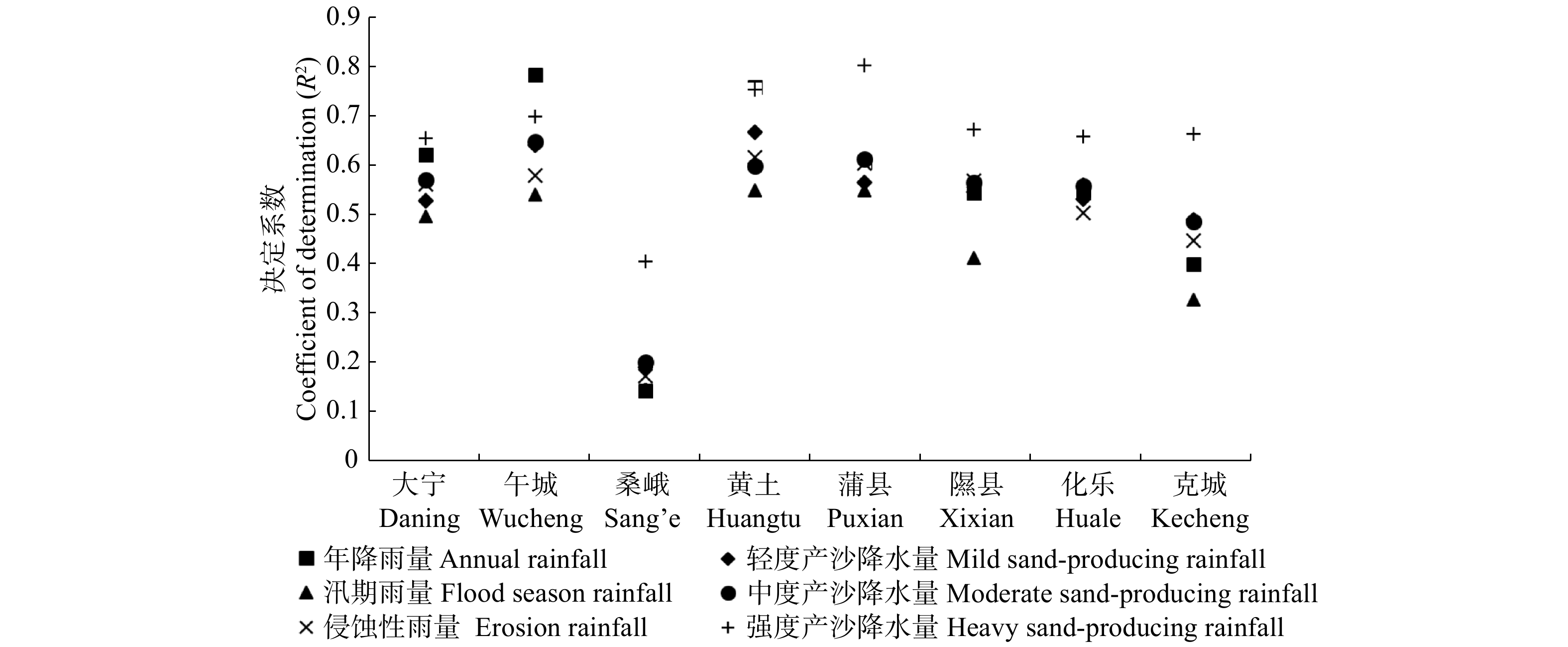
图 11 不同雨量站降水输沙相关关系决定系数
雨量站距流域出口河道距离分别为:大宁(0 km),午城(13.9 km),桑峨(36.4 km),黄土(41.2 km),蒲县(42.5 km),隰县(46.5 km),化乐(51.7 km),克城(61.3 km)。Distance between rainfall station and hydrological station are as follows: Daning (0 km), Wucheng (13.9 km), Sang’e (36.4 km), Huangtu (41.2 km), Puxian (42.5 km), Xixian (46.5 km), Huale (13.9 km), Kecheng (61.3 km).
Figure 11. Determination coefficients between rainfall and sediment discharge in different rainfall stations
表 1 不同统计标准降水输沙Pearson相关系数
Table 1 Pearson correlation coefficients between rainfall and sediment discharge under different statistical standards
统计标准
Statistical standard年降雨量
Annual
rainfall汛期降雨量
Flood season
rainfall侵蚀性降雨量
Erosion
rainfall轻度产沙降雨量
Mild sand-producing rainfall中度产沙降雨量
Moderate sand-producing rainfall强度产沙降雨量
Heavy sand-producing rainfallPearson相关系数
Pearson correlation coefficient0.821** 0.749** 0.800** 0.779** 0.795** 0.884** 注:**表示在P < 0.01水平显著相关。Note: ** means significant correlation at P < 0.01 level.  下载: 导出CSV
表 2 典型场降雨日降雨量与日输沙量
Table 2 Daily rainfall and daily sediment discharge in typical rainfall events
降雨编号
Rainfall No.年
Year月
Month日
Day日降雨量 Daily rainfall/mm 输沙量
Sediment
discharge/t隰县
Xixian化乐
Huale克城
Kecheng黄土
Huangtu午城
Wucheng桑峨
Sang’e大宁
Daning蒲县
PuxianR1# 1968 10 4 1.5 4.5 0.5 0.5 0 5 6.8 37.0 10.7 11.3 11.1 7.8 13.0 0 6 26.9 33.1 28.0 8.4 3.5 20.6 12.8 9.0 139.1 7 0.4 19.0 6.5 5.5 17.3 11.6 16.2 1 797.1 8 27.1 27.9 12.0 10.4 6.0 7.9 12.0 14.3 2 712.9 9 11.4 20.5 15.0 16.2 7.5 16.8 17.8 18.4 22 723.2 10 15.7 10.0 6.8 4.0 14.7 9.8 10.6 34 732.8 11 8.4 10.2 9.4 6.1 7.0 10.0 6.9 8.4 24 883.2 12 2.4 2.7 2.2 6.5 2.5 1.8 2.6 8 553.6 合计 Sum 83.4 107.4 133.1 68.8 55.8 100.9 81.0 93.0 95 541.9 年总值 Annual gross value 370.2 440.2 560.4 391.4 370.1 625.4 430.4 477.6 118 22 515.0 占全年总量 Percentage in the whole year/% 22.53 24.40 23.75 17.58 15.08 16.13 18.82 19.47 0.81 R2# 1971 6 1 0.1 2.0 0 2 21.9 26.9 24.2 24.9 26.8 38.6 31.5 28.6 66.2 3 0.2 692.1 合计 Sum 22.2 26.9 24.2 24.9 26.8 38.6 31.5 30.6 758.25 年总值 Annual gross value 420.2 590.1 696.3 526.3 564.8 767.2 609.0 663.9 31 966 962.0 占全年总量 Percentage in the whole year/% 5.28 4.56 3.48 4.73 4.75 5.03 5.17 4.61 0
下载: 导出CSV
表 3 典型场降雨日降雨量与日输沙相关指标
Table 3 Relative parameters of daily rainfall and daily sediment discharge in typical rainfall events
降雨
编号
Rainfall No.年
Year月
Month日
Day日降雨量 Daily rainfall/mm 平均含沙量
Mean sediment
concentration/
(kg·m−3)平均流量
Mean streamflow/
(m3·s−1)平均输沙率
Mean sediment discharge rate/
(kg·s−1)输沙量
Sediment
discharge/t隰县
Xixian化乐
Huale克城
Kecheng黄土
Huangtu午城
Wucheng桑峨
Sang’e大宁
Daning蒲县
PuxianR3# 1961 6 25 24.6 62.5 — 25.0 23.3 29.5 40.0 0.000 0.714 0.000 0.0 26 14.1 5.5 — 37.6 15.5 20.3 12.0 34.364 16.500 567.000 48 988.800 27 20.4 34.5 — 4.4 45.9 22.6 42.5 8.000 10.500 84.000 7 257.6 28 7.6 — 3.0 4.5 2.0 49.784 23.100 1 150.000 99 360.0 29 5.882 8.670 51.000 4 406.4 合计 Sum 66.7 0 102.5 — 67.0 87.7 76.9 96.5 160 012.8 年总值
Annual gross value651.0 412.0 671.3 — 380.0 643.0 620.0 586.0 16 345 243.8 占全年总量
Percentage in the whole year/%10.25 0 15.27 — 17.63 13.64 12.40 16.47 0.98 R4# 1961 7 14 3.3 22.0 19.0 — 2.5 14.0 11.0 11.0 15.399 3.260 50.200 4 337.3 7 15 0.5 20.0 6.0 — 30.0 26.8 3.0 3.400 5.000 17.000 1 468.8 7 16 68.5 40.0 — 60.0 15.0 11.6 21.5 537.190 242.000 130 000.000 11 232 000.0 7 17 — 111.905 29.400 3 290.000 284 256.0 合计 Sum 72.3 42.0 65.0 — 92.5 29.0 49.4 35.5 11 522 062.1 年总值
Annual gross value651.0 412.0 671.3 — 380.0 643.0 620.0 586.0 16 345 243.8 占全年总量
Percentage in
the whole year/%11.11 10.19 9.68 — 24.34 4.51 7.97 6.06 70.49 R5# 1970 6 4 8.5 4.0 0.226 6.340 1.430 123.6 5 0.3 9.0 7.0 0 6.7 7.8 0.175 5.530 0.968 83.6 6 17.6 24.8 16.4 14.3 23.6 19.1 0.080 5.530 0.442 38.2 7 15.5 11.0 1.2 9.9 5.8 5.2 11.4 0.407 13.400 5.460 471.7 8 0.9 1.5 4.5 0 1.3 1.2 1.240 15.200 18.800 1 624.3 9 0.5 0.6 0.5 0.726 13.300 9.660 834.6 合计 Sum 34.3 28.5 34.5 35.3 20.1 0 37.4 40.0 3 176.1 年总值
Annual gross value418.4 361.0 474.5 363.1 358.2 382.3 395.8 492.8 12 085 055.8 占全年总量
Percentage in
the whole year/%8.20 7.89 7.27 9.72 5.61 0 9.45 8.12 0.03 R6# 1963 5 17 23.0 — — 0 3.030 0 0 18 5.9 18.4 — — 15.6 26.7 0 3.030 0 0 19 20.1 2.5 — — 1.2 3.2 0.204 5.900 1.200 103.7 20 16.0 — — 0.151 7.450 1.120 96.8 21 44.0 22.0 — — 18.3 7.4 0.083 6.220 0.520 44.6 22 39.2 6.0 7.6 — — 19.6 19.0 27.500 10.700 294.000 25 401.6 23 11.0 21.0 8.5 — — 10.7 5.5 73.600 48.900 3 600.000 311 040.0 24 7.3 6.5 15.3 — — 11.9 19.4 7.930 46.100 366.000 31 622.4 25 9.1 4.0 — — 3.4 3.4 9.500 56.400 536.000 46 310.4 26 3.5 — — 3.760 54.800 206.000 17 798.4 27 3.5 — — 1.840 47.300 87.000 7 516.8 28 0.9 3.0 — — 0.7 1.0 1.160 35.200 40.800 3 525.1 29 9.1 — — 0.6 0.495 30.700 15.200 1 313.3 合计 Sum 106.1 0 123.0 78.3 — — 81.4 86.2 444 773.0 年总值
Annual gross value696.6 384.0 822.9 628.9 — — 599.9 671.8 35 819 211.7 占全年总量
Percentage in
the whole year/%15.23 0 14.95 12.45 — — 13.57 12.83 1.24 注:“—”表示无数据,空白表示当日无降雨。下同。Notes: “—” means no data; blank means no rain. The same below.
下载: 导出CSV
表 4 不同雨量站典型场降雨日降雨量与输沙量
Table 4 Daily rainfall and sediment discharge in typical rainfall events of varied rainfall stations
降雨编号
Rainfall No.年
Year月
Month日
Day日降雨量 Daily rainfall/mm 输沙量
Sediment
discharge/t隰县
Xixian化乐
Huale克城
Kecheng黄土
Huangtu午城
Wucheng桑峨
Sang’e大宁
Daning蒲县
PuxianR7# 1962 8 24 51.0 — 61.0 7.0 18.8 0 25 48.9 20.0 — 9.0 25.9 39.2 513 216.0 26 48.0 — 27.5 70 416.0 合计 Sum 48.9 68.0 51.0 — 61.0 16.0 53.4 58.0 583 632.0 年总值 Annual gross value 540.1 694.5 859.7 — 609.5 391.7 593.5 740.3 26 455 384.0 占全年总量 Percentage in the whole year/% 9.05 9.79 5.93 — 10.01 4.08 9.00 7.83 2.21 R8# 1969 9 19 1.5 11.0 30.5 6.5 2.1 2.4 2.1 0.9 0 20 45.4 7.0 21.0 39.2 52.7 34.3 35.1 30.7 50 371.2 21 0.7 10.0 0.1 6.4 8.8 4.8 5.4 129 600.0 22 0.6 6.0 10.0 4.9 7.9 11.7 5.3 10.0 2 600.6 23 6.9 7.0 0.2 1.5 1.2 4.9 0.5 0.1 365.5 24 14.9 9.0 37.0 19.7 19.3 10.4 16.1 9.9 115.8 25 19.4 21.0 5.4 8.7 7.9 7.2 11.2 2 116.8 26 102.8 12.0 11.0 13.2 11.4 10.4 12.2 9.8 6 048 000.0 27 8.7 6.0 17.0 10.2 14.3 16.8 11.2 9.2 69 033.6 28 12.2 6.0 22.0 11.9 18.5 23.9 16.7 18.5 7 102.1 29 21.0 6.5 2.2 4.3 5.8 5.3 5.4 40 348.8 30 24 537.6 合计 Sum 234.1 74.0 176.3 114.7 146.8 137.3 116.5 111.1 6 374 192.0 年总值 Annual gross value 698.0 583.6 699.3 585.5 566.3 625.5 496.8 659.4 40 301 823.0 占全年总量 Percentage in the whole year/% 33.54 12.68 25.21 19.59 25.92 21.95 23.45 16.85 15.82
下载: 导出CSV
-
[1] 张守红, 刘苏峡, 莫兴国, 等. 降雨和水保措施对无定河流域径流和产沙量影响[J]. 北京林业大学学报, 2010, 32(4):161−168. Zhang S H, Liu S X, Mo X G, et al. Impacts of precipitation variation and soil and water conservation measures on runoff and sediment yield in the Wuding River Basin, middle reaches of the Yellow River[J]. Journal of Beijing Forestry University, 2010, 32(4): 161−168.
[2] 曹文洪, 姜乃森, 付玲燕. 浑河流域水土保持减沙效益分析[J]. 人民黄河, 1993(11):18−21, 50. Cao W H, Jiang N S, Fu L Y. Analysis on water and sediment reduction benefits through soil conservation measures of the Hun River Basin[J]. Yellow River, 1993(11): 18−21, 50.
[3] 赵文林, 焦恩泽, 王广任, 等. 三川河水沙变化及人类活动影响[J]. 人民黄河, 1992(11):22−26. Zhao W L, Jiao E Z, Wang G R, et al. Water and sediment variations of Sanchuan River and effects by human activities[J]. Yellow River, 1992(11): 22−26.
[4] 焦恩泽. 孤山川流域水沙变化趋势的分析[J]. 人民黄河, 1992(6):15−19. Jiao E Z. Analysis on variation trend of runoff and sediment of Gushanchuan Watershed[J]. Yellow River, 1992(6): 15−19.
[5] 熊维新, 王宏, 张治忠. 渭河流域水利水保措施减水减沙效益初步分析[J]. 人民黄河, 1992(7):21−25. Xiong W X, Wang H, Zhang Z Z. Analysis on benefits of hydraulic projects and soil conservation measures in reductions of runoff and sediment in Wei River[J]. Yellow River, 1992(7): 21−25.
[6] 慕星, 张晓明. 皇甫川流域水沙变化及驱动因素分析[J]. 干旱区研究, 2013, 30(5):933−939. Mu X, Zhang X M. The variation of runoff volume and sediment load and its driving factors in Huangfuchuan River Watershed[J]. Arid Zone Research, 2013, 30(5): 933−939.
[7] 莫莉. 基于水文法的北洛河流域水土保持措施减沙水代价分析[D]. 杨凌: 西北农林科技大学, 2008. Mo L. Runoff cost of sediment control of soil and water conservation practices with hydrologic methods in Beiluo River Basin[D]. Yangling: Northwest A&F University, 2008.
[8] 徐学选, 高朝侠, 赵娇娜. 1956—2009年延河水沙变化特征及其驱动力研究[J]. 泥沙研究, 2012(2):12−18. doi: 10.3969/j.issn.0468-155X.2012.02.003. Xu X X, Gao Z X, Zhao J N. Trends of runoff and sediment load of Yanhe River Basin and their related driving forces during 1956−2009[J]. Journal of Sediment Research, 2012(2): 12−18. doi: 10.3969/j.issn.0468-155X.2012.02.003.
[9] 许炯心. 黄河中游多沙粗沙区1997—2007年的水沙变化趋势及其成因[J]. 水土保持学报, 2010, 24(1):1−7. Xu J X. Trend of sediment yield in the coarser sediment-producing area in the middle Yellow River Basin in the period 1997−2007 and the formative cause[J]. Journal of Soil and Water Conservation, 2010, 24(1): 1−7.
[10] 毕彩霞. 黄河中游皇甫川流域产沙性降雨及其对径流输沙的影响[D]. 北京: 中国科学院研究生院(教育部水土保持与生态环境研究中心), 2013. Bi C X. Study on watershed sediment yield rainfall and contributions of the watershed sediment yield rainfall to runoff and sediment in Huangfuchuan River Basin[D]. Beijing: Graduate University of Chinese Academy of Sciences (Research Center of Soil and Water Conservation and Ecological Environment, Chinese Academy of Sciences and Ministry of Education), 2013.
[11] 王正文, 韩学士, 赵昕, 等. 皇甫川流域水沙变化原因分析[J]. 中国水土保持, 2000(5):26−27. Wang Z W, Han X S, Zhao X, et al. Analysis of water and sediment changes in Huangfuchuan Watershed[J]. Soil and Water Conservation in China, 2000(5): 26−27.
[12] 罗文生, 赵辉. 基于次降雨条件下的武水流域径流输沙规律研究[J]. 西南林学院学报, 2010, 30(1):6−10. Luo W S, Zhao H. Study on runoff and sediment transport of Wushui watershed in Hunan Province based on the data of single rainfall[J]. Journal of Southwest Forestry University, 2010, 30(1): 6−10.
[13] 姚文艺, 冉大川, 陈江南. 黄河流域近期水沙变化及其趋势预测[J]. 水科学进展, 2013, 24(5):607−616. Yao W Y, Ran D C, Chen J N. Recent changes in runoff and sediment regimes and future projections in the Yellow River Basin[J]. Advances in Water Science, 2013, 24(5): 607−616.
[14] 王国庆, 张建云, 贺瑞敏, 等. 黄土高原昕水河流域径流变化归因定量分析[J]. 水土保持研究, 2014, 21(6):295−298. Wang G Q, Zhang J Y, He R M, et al. Attribution of runoff change for the Xinshui River Basin in the Loess Plateau of China[J]. Research of Soil and Water Conservation, 2014, 21(6): 295−298.
[15] 张建兴, 马孝义, 屈金娜. 昕水河流域水沙变化趋势及成因分析[J]. 人民黄河, 2007, 29(12):36−38. doi: 10.3969/j.issn.1000-1379.2007.12.018. Zhang J X, Ma X Y, Qu J N. Water and sediment trends and their causes in the Xinshui River Watershed[J]. Yellow River, 2007, 29(12): 36−38. doi: 10.3969/j.issn.1000-1379.2007.12.018.
[16] Mann H B. Nonparametric test against trend[J]. Econometrica, 1945, 13(3): 245−259. doi: 10.2307/1907187.
[17] Kendall M G. Rank correlation methods[M]. 4th ed. London: Charles Griffin, 1975.
[18] 袁满, 王文圣, 叶濒璘. 有序聚类分析法的改进及其在水文序列突变点识别中的应用[J]. 水文, 2017, 37(5):8−11. doi: 10.3969/j.issn.1000-0852.2017.05.002. Yuan M, Wang W S, Ye B L. Improvement of sequential clustering method and its application to diagnose jump points of hydrological series[J]. Journal of China Hydrology, 2017, 37(5): 8−11. doi: 10.3969/j.issn.1000-0852.2017.05.002.
[19] 穆兴民, 张秀勤, 高鹏, 等. 双累积曲线方法理论及在水文气象领域应用中应注意的问题[J]. 水文, 2010, 30(4):47−51. doi: 10.3969/j.issn.1000-0852.2010.04.011 Mu X M, Zhang X Q, Gao P, et al. Theory of double mass curves and its applications in hydrology and meteorology[J]. Journal of China Hydrology, 2010, 30(4): 47−51. doi: 10.3969/j.issn.1000-0852.2010.04.011
[20] 赵玉. 渭河流域典型水库淤积及其对径流输沙的影响[D]. 北京: 中国科学院大学(教育部水土保持与生态环境研究中心), 2014. Zhao Y. Typical reservoirs sedimentation and their’s influence on runoff and sediment transport in Weihe River Basin[D]. Beijing: Graduate University of Chinese Academy of Sciences (Research Center of Soil and Water Conservation and Ecological Environment, Chinese Academy of Sciences and Ministry of Education), 2014.
[21] 岳晓丽. 黄河中游径流及输沙格局变化与影响因素研究[D]. 杨凌: 西北农林科技大学, 2016. Yue X L. Spatial patterns and trends in runoff and sediment load in the middle reaches of the Yellow River and their potential cause[D]. Yangling: Northwest A&F University, 2016.
[22] 张建勇, 高冉, 胡骏, 等. 灰色关联度和Pearson相关系数的应用比较[J]. 赤峰学院学报(自然科学版), 2014, 30(11):1−2. Zhang J Y, Gao R, Hu J, et al. Application comparison of gray relation analysis and the Pearsons’s correlation coefficient[J]. Journal of Chifeng University (National Science Edition), 2014, 30(11): 1−2.
[23] 司海松. 黄河中游陕西境内多沙粗沙区水沙变化研究[D]. 西安: 西安理工大学, 2017. Si H S. Study on variation of runoff and sediment in coarser sediment-producing area of Shaanxi Province in the middle reaches of the Yellow River[D]. Xi’an: Xi’an University of Technology, 2017.
[24] 谢云, 刘保元, 章文波. 侵蚀性降雨标准研究[J]. 水土保持学报, 2000, 14(4):6−11. doi: 10.3321/j.issn:1009-2242.2000.04.002. Xie Y, Liu B Y, Zhang W B. Study on standard of erosive rainfall[J]. Journal of Soil and Water Conservation, 2000, 14(4): 6−11. doi: 10.3321/j.issn:1009-2242.2000.04.002.
[25] 柳莎莎, 王厚杰, 张勇, 等. 气候变化和人类活动对黄河中游输沙量影响的甄别[J]. 海洋地质与第四纪地质, 2014(4):41−50. Liu S S, Wang H J, Zhang Y, et al. Impacts of climate change and human activity on sediment discharge in the middle reach of the Yellow River[J]. Marine Geology & Quaternary Geology, 2014(4): 41−50.
[26] 王万忠. 黄土地区降雨特性与土壤流失关系的研究Ⅲ—关于侵蚀性降雨的标准问题[J]. 水土保持通报, 1984(2):58−63. Wang W Z. Study on the relations between rainfall characteristics and loss of soil in the loess region[J]. Bulletin of Soil and Water Conservation, 1984(2): 58−63.
[27] 周佩华, 王占礼. 黄土高原土壤侵蚀暴雨标准[J]. 水土保持通报, 1987, 7(1):38−44. Zhou P H, Wang Z L. Soil erosion storm rainfall standard in the Loess Plateau[J]. Bulletin of Soil and Water Conservation, 1987, 7(1): 38−44.
[28] 王占礼, 焦菊英. 黄土高原长历时土壤侵蚀暴雨标准初探[J]. 水土保持通报, 1992, 12(3):25−28. Wang Z L, Jiao J Y. A preliminary discussion on the criterion of long duration rainstorm for soil erosion in the Loess Plateau[J]. Bulletin of Soil and Water Conservation, 1992, 12(3): 25−28.
[29] Wischmeier W H, Smith D D. Predicting rainfall erosion losses: a guide to conservation planning [M]//Agricultural handbook. Washington: US Department of Agriculture, 1978.
[30] 何毅. 黄河河口镇至潼关区间降雨变化及其水沙效应[D]. 杨凌: 西北农林科技大学, 2016. He Y. Variations of erosive and extreme rainfall and their effects on runoff and sediment load in Hekouzhen-Tongguan reach of the Yellow River[D]. Yangling: Northwest A&F University, 2016.
[31] 张岩, 朱清科. 黄土高原侵蚀性降雨特征分析[J]. 干旱区资源与环境, 2006, 20(6):99−103. doi: 10.3969/j.issn.1003-7578.2006.06.019. Zhang Y, Zhu Q K. Statistic analysis of erosive rainfall on the Loess Plateau[J]. Journal of Arid Land Resources and Environment, 2006, 20(6): 99−103. doi: 10.3969/j.issn.1003-7578.2006.06.019.
[32] 冉大川, 焦鹏, 姚文艺, 等. 泾河东川近期水沙变化对高强度人类活动的响应[J]. 水土保持学报, 2015, 29(2):23−29. Ran D C, Jiao P, Yao W Y, et al. Recent variation of runoff and sediment in response to the high intensity human activities in Dongchuan Basin of Jinghe River[J]. Journal of Soil and Water Conservation, 2015, 29(2): 23−29.
[33] 赵越. 祖厉河流域水沙变化特征及水土保持减水减沙效益研究[D]. 兰州: 甘肃农业大学, 2016. Zhao Y. Study on variation characteristics of water and sediment and sediment reduction benefits of water and soil conservation in Zuli River Basin[D]. Lanzhou: Gansu Agricultural University, 2016.
[34] 于一鸣. 黄河流域水土保持减沙计算方法存在问题及改进途径探讨[J]. 人民黄河, 1996(1):26−30. Yu Y M. Problem in calculation methods of sediment reduction by soil and water conservation measures in the Yellow River Basin and approach to improvement[J]. Yellow River, 1996(1): 26−30.


计量
- 文章访问数: 1204
- HTML全文浏览量: 435
- PDF下载量: 45
