
Planning of debris flow prevention forest in shallow mountain area of Beijing from the perspective of human settlement environment safety
-
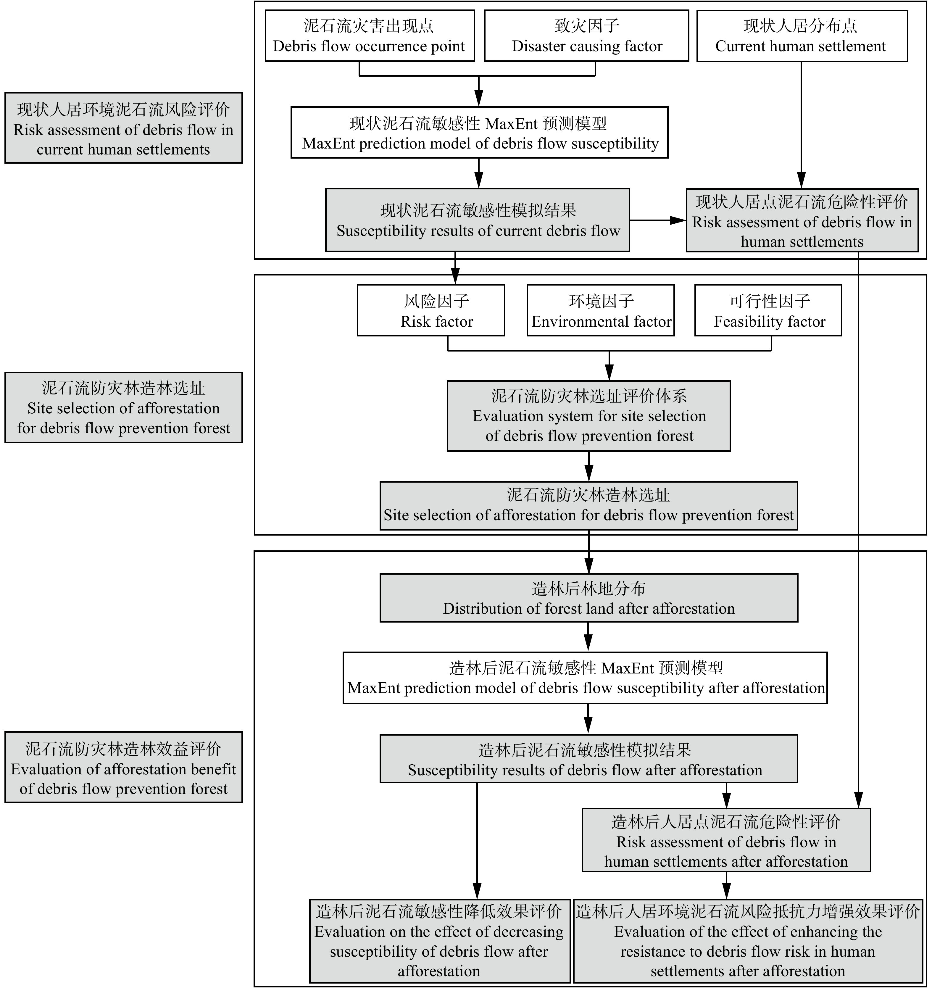
摘要:目的 城市边缘的浅山区是人类生产生活与自然生境的交接缓冲区,也是人居环境面对泥石流等自然灾害风险脆弱性较高的区域。相比通过工程方法降低浅山区中自然灾害威胁,防灾林选址规划作为基于生态系统的方法,可以恢复健康的生态系统,提供多样的生态系统服务并有效降低灾害风险,提高人居环境对自然灾害的抵抗力与适应力。方法 本研究提出一种人居环境安全视角下的泥石流防灾林造林选址评价体系,并评估规划的防灾林对降低人居环境中泥石流风险的有效性。基于多准则决策法(AHP),将基于最大熵模型(MaxEnt)的泥石流敏感性预测结果作为泥石流风险因子,识别具有降低泥石流灾害发生概率的泥石流流域内适宜造林位置作为环境因子,同时结合造林可行性因子,叠加3类因子分析出高风险且高适宜的造林区域。通过对比造林前后泥石流敏感性与人居点危险性评价造林的减灾效益,指导北京市浅山区泥石流防灾林造林选址。结果 研究选取了118.50 km2的造林区域,主要分布在密云水库周边地区、怀柔区、昌平区以及房山区,呈现以零散斑块形态分布在人居点上游的特征。造林后泥石流易发区面积减少了117.45 km2,位于泥石流易发区的人居点个数减少了51个。结论 本研究构建了提升人居环境泥石流抵抗力的防灾林造林选址评价体系,通过基于自然系统的方法降低山区自然灾害风险,提升浅山区人居环境质量,保障生态系统健康与人居环境安全,并为北京市百万亩造林计划提供理论依据。Abstract:Objective The shallow mountain area on the edge of city is the buffer zone where human production and living meet the natural habitat. It is also an area where the human settlement environment is more vulnerable to natural disaster risks such as debris flows. Compared with reducing the threat of natural disasters in shallow mountain areas through engineering methods, disaster prevention forest site planning as an ecosystem-based approach, can restore healthy ecosystem, provide diverse ecosystem services, and effectively reduce the risk of natural disasters, so as to improve the resistance and adaptability of human settlements to natural disasters.Method This study proposed a site selection system of debris flow disaster prevention forest from the perspective of human settlement safety, and evaluated the effectiveness of planned disaster prevention forest to reduce the risk of debris flow in human settlements. Based on analytic hierarchy process (AHP), the susceptibility prediction of debris flow based on maximum entropy model (MaxEnt) was taken as debris flow risk factor, and suitability of afforestation locations in the debris flow basin that reduce the probability of debris flow disasters was taken as environmental factor for afforestation, and combined with afforestation feasibility factor, three kinds of factors were superimposed to analyze the areas with high debris flow risk and suitable for afforestation. The susceptibility of debris flow and the risk of human settlements before and after afforestation were evaluated to assess the disaster reduction benefits of afforestation, and to guide the afforestation site selection of debris flow disaster prevention forest in shallow mountain area of Beijing.Result The study selected 118.50 km2 of afforestation area, mainly distributed in the surrounding areas of Miyun Reservoir and the mountainous areas of Huairou District, Changping District and Fangshan District of Beijing, showing the characteristics of scattered patches distributed in the upstream of human settlements. The area of debris flow high-prone area decreased by 117.45 km2, and the number of settlements in the debris flow high-prone area decreased by 51.Conclusion The purpose of this study is to build a framework for afforestation site selection that enhances resistance to debris flows in human settlements, in order to reduce the risk of natural disasters in mountainous areas through ecosystem-based approach, improve the quality and safety of human settlements, protect the health of ecosystem, and provide a theoretical basis for the Beijing a-Million-Mu Afforestation and Greening Action Plan.
-
云南金钱槭(Dipteronia dyerana)是隶属于槭树科(Aceraceae)金钱槭属的一种落叶乔木,仅分布于云南东南部及贵州西南部海拔2 000~2 500 m的疏林中,为国家Ⅱ级珍惜濒危保护植物[1]。长期以来,云南金钱槭的种级系统位置界定,主要依据其独特的形态学特征(翅果成圆环形等),并与金钱槭(Dipteronia sinensis)共同组成我国特有属——金钱槭属。
金钱槭属作为槭属(Acer)的姐妹属,常作为槭属等相关研究的外类群,但它常常不能形成单系群或属内物种嵌于槭属中。Tian等[2]采用ITS和trnL-F片段对槭属进行系统学研究中,云南金钱槭内嵌于槭属,导致金钱槭属没有形成单系群;Pfosser等[3]在关于亚洲槭属物种的亲缘关系重建中,金钱槭内嵌于槭属之内,导致金钱槭属在分析中不能作为外群;Grimm等[4]使用ITS片段,利用最大似然法构建槭属系统发育树时,云南金钱槭出现在槭属内部;Li等[5]研究发现,在最大简约法(MP)和最大似然法(ML)构建系统树时,金钱槭属的物种不能形成单系群。此外,相对早期的研究也存在类似情况[6-7]。Yang等[8]虽对此进行了讨论,但目标基因片段选择相对较少,且对于槭属属内分类组的辅助研究材料选择较为局限。因此,对云南金钱槭在其近缘物种中进行系统位置的确定研究,具有重要的理论与实践意义。
近年来,在物种系统位置相关分析中,基因片段的选择多集中于核ITS片段以及叶绿体trnL-trnF、rbcL、rpl16等片段[9-15]。此外,在金钱槭属及槭属的研究中,也常使用叶绿体psbM-trnD、trnD-trnT片段[5]以及psbA-trnH片段等(未发表数据)。因此,本研究选取8个基因片段,包括6个叶绿体基因片段(psbM-trnD、rbcL、trnD-trnT、rpl16、trnL-trnF和psbA-trnH)与2个核基因片段(ITS与CHS),研究金钱槭属及其近缘属(槭属)的系统发育关系。通过多基因组合系统学分析,尝试理清云南金钱槭的系统位置及其与近缘类群的系统关系,并为其姐妹属(例如:槭属、七叶树属、掌叶木属等)的研究提供帮助。
1. 材料与方法
1.1 实验材料
本研究以云南金钱槭为材料,并在槭树属内14个分类组中[16],每组各选取一个物种作为辅助材料(其中psbM-trnD、trnD-trnT与CHS选取不足14个)(表 1)。此外,七叶树属(Aesculus)作外群。叶绿体基因psbM-trnD、rbcL、trnD-trnT片段与核基因ITS片段序列全部选自GenBank,叶绿体基因rpl16、trnL-trnF与psbA-trnH片段大部分为本实验所得,核基因CHS片段全部为本实验所得(表 1)。每个实验物种采集其幼嫩叶片,分别放入置有变色硅胶的取样袋中干燥、备用。同时,压制凭证标本经由北京林业大学博士生高健鉴定并存放于北京林业大学林学院。
表 1 试验材料及其序列号Table 1. Species used in this study and their GenBank accession numbers属
Genera组
Section来源
Source编号
Code采集者
Collector种
Species序列登录号GenBank accession No. ITS CHS psbM- trnD rbcL trnD- trnT rpl16 trnH-PsbA trnL-F 七叶树属
Aesculus青秀山,南宁Qingxiu Mountain, Nanning k028 陆志成
LU Zhi-chengA. wangii AF406968 KX000286* NCBI A. glabra DQ659840 AY968623 NCBI A. flava DQ978441 AY968613 DQ978509 DQ978642 DQ978573 NCBI A. parviflora DQ978448 DQ978510 DQ978643 DQ978574 上海植物园,上海Shanghai Botanical Garden, Shanghai i008 杜宝明
DU Bao-mingA. chinensis KX000285* 金钱槭属
Diteronia堵河源保护区,十堰
Duheyuan National Nature Reserve, Shiyany010 郑德国
ZHENG De-guoD. dyerana DQ238333 KX000287* DQ659838 DQ978443 DQ659778 DQ978512 DQ978645 DQ978576 青秀山,南宁Qingxiu
Mountain, Nanningk029b 陆志成
LU Zhi-chengD. sinensis AY605290 KX000288* DQ659839 DQ978444 DQ659779 KU500460* KU500519* KU522513* 槭属
Acer尖齿枫组
sect. Arguta安图县,延边Antu
County, Yanbianq004 刘琪璟
LIU Qi-jingA. barbinerve AJ634569 KX000274* DQ978395 KU500434* KU500513* KU522490* NCBI A. acuminatum DQ659841 DQ659781 全缘叶枫组
sect. Oblonga上海植物园,上海
Shanghai Botanical Garden, Shanghaii002 杜宝明
DU Bao-mingA. buergerianum AY605466 KX000275* DQ659843 DQ659783 KU500435* KU500514* KU522491* NCBI A. buergerianum var. formosanum DQ978396 枫组sect. Acer NCBI A. caesium subsp. giraldii AY605295 DQ659893 DQ978397 DQ659833 DQ978453 DQ978584 DQ978519 穗状枫组
sect. SpicataNCBI A. caudatum subsp. multiserratum AY605432 DQ978401 华南植物园,广州South
China Botanical Garden, Guangzhoud005 简曙光
lJIAN Shu-guangA. caudatum KX000276* DQ659887 DQ659827 KU500444* KU500509* KU522508* 大花枫组
sect. MacranthaNCBI A. davidii subsp. davidii AY605392 DQ978406 浙江农林大学,临安
Zhejiang Agriculture and Forestry University, Lin’ano001 陈秋夏
CHEN Qiu-xiaA. davidii KX000277* DQ659848 DQ659788 浙江农林大学,临安
Zhejiang Agriculture and Forestry University, Lin'ano006 陈秋夏
CHEN Qiu-xiaA. davidii subsp. grosseri KU500459* KU500550* KU522512* 鸡爪枫组
sect. PalmataNCBI A. palmatum subsp. palmatum AY605425 中科院植物所,北京
Institute of Botany, Chinese Academy of Sciences, Beijingb015 廖培钧
LIAO Pei-junA. palmatum KX000280* DQ659867 DQ978421 DQ659807 KU500472* KU500503* KU522530* 三小叶枫组
sect. Trifoliata堵河源保护区,十堰
Duheyuan National Nature Reserve, Shiyany005 郑德国
ZHENG De-guoA. griseum AY605467 KX000278* DQ659857 DQ978411 DQ659797 KU500463* KU500530* KU522514* 扁果枫组
sect. HyptiocarpaNCBI A. laurinum AM113541 DQ978413 DQ659794 DQ978473 DQ978604 DQ978536 复叶枫组
sect. Negundo华南植物园,广州South
China Botanical Garden, Guangzhoud001a 简曙光
JIAN Shu-guangA. negundo AY605406 KX000279* DQ659864 DQ978417 DQ659804 KU500471* KU500535* KU522527* 五小叶枫组
sect. Pentaphtlla茂县,阿坝藏族羌族自治州Maoxian County, Aba Tibetan and Qiang Autonomous Prefecture u003 包维楷
BAO Wei-kaiA. pentaphyllum DQ238478 KX000281* DQ659870 DQ978422 DQ659810 KU500474* KU500538* KU522534* 疏毛枫组sect.
Pubescentia中科院植物所,北京Institute of Botany, Chinese Academy of Sciences, Beijing b013 廖培钧
LIAO Pei-junA. pilosum DQ238345 DQ978423 KU500491* KU500546* KU522535* NCBI A. pilosum var. stenolobum KX000282* 桐状枫组sect.
Platanoidea黑龙江森林植物园,哈尔滨Heilongjiang Forest Botanical Garden, Harbin h004 毛子军
MAO Zi-junA. pictum subsp. mono LK022665 KU500431* KU500534* KU522525* NCBI A. pictum subsp. pictum AB872557 茶条枫组
sect. Ginnala黑龙江森林植物园,哈尔滨Heilongjiang Forest Botanical Garden, Harbin h002 毛子军
MAO Zi-junA. tataricum subsp. ginnala AY605363 KX000284* DQ659855 DQ978436 DQ659795 KU500479* KU500521* KU522544* NCBI A. sterculiaceum subsp. franchetii DQ366145 DQ978435 坚果枫组
sect. Lithocarpa紫金山,南京Zijin Mountain, Nanjing m008 葛之葳
GE Zhi-weiA. sinopurpurascens KX000283* DQ659878 DQ659818 KU500490* KU500545* KU522538* 注:*代表本研究中获得的序列。Notes: * represents sequences obtained in present study; NCBI, National Center for Biotechnology Information. 1.2 DNA提取、聚合酶链式反应(PCR)及测序
每份样品取约0.2 g干燥叶片,采用植物基因组DNA小型提取试剂盒(Plant Genomic DNA kit)基因组DNA。叶绿体基因组片段rpl16、trnL-trnF、psbA-trnH和核基因组片段CHS的PCR扩增均在Labnet MultiGeneTM 96-well Gradient Thermal Cycler上完成。PCR反应体系为20 μL,主要包含DNA模板10 ~ 30 ng、50 mmol/L Tris-HCl、1.5 mmol/L MgCl2、1 mmol/L dNTPs、各0.3 μL的正反引物、0.2 U Taq DNA聚合酶(博尔纳德股份有限公司,台湾)。PCR反应程序为:94 ℃预变性3 min;94 ℃变性30 s,52~58 ℃退火30 s,72 ℃延伸60 s,共30个循环;最后72 ℃延伸10 min。PCR扩增产物经1%琼脂糖凝胶电泳检测后,送往台湾基龙米克斯生物科技股份有限公司并在ABI3730XL遗传分析仪上进行测序。
1.3 数据分析
利用Bioedit 7.1.11软件[17]对获得的基因组片段序列进行整理、拼接以及校正,将经手工矫正后的各基因组片段的序列提交至GenBank,其登录号见表 1。采用MP法与贝叶斯法(BI)分别构建8个单独基因以及6个叶绿体联合基因的系统发育关系。PAUP 4.0b10软件进行MP法分析时,空位(Gap)作为缺失状态,采用启发式搜索(Heuristic search)进行1 000次随机加入,以TBR(tree-bisection-reconnection)进行枝长交换,得到的系统树分枝的可靠性评价使用自展分析(bootstrap, BS)。BI法分析使用MrBayes ver.3.2,利用Modeltest ver.2.2进行模型和参数估计,选择最适碱基替代模型。贝叶斯推断以随机树(random tree)开始分析,2条马尔可夫链(Markov Chain Monte Carlo, MCMC)同时运行,温度参数值设为0.2,共运行1 000 000代,每100代保留1棵树。前25%代作为动态老化样本(burn-in samples)被舍弃,仅对剩余的静态抽样计算一致性树(consensus tree)并计算相关参数,一致性树上的各分支可信度评价用后验概率(posterior probability, PP)表示。
2. 结果与分析
2.1 6个叶绿体基因单独及联合数据分析
在6个叶绿体基因单独分析中,云南金钱槭与其属内姐妹种金钱槭形成单系群的有rbcL(BS=87%,PP=100%)与rpl16(BS=90%,PP=98%)片段;psbA-trnH、trnD-trnT与trnL-trnF片段能把金钱槭属与槭属植物很好分开,但不支持属内两个物种形成单系群;而psbM-trnD片段的结果显示金钱槭属与槭属混在一起,形成并系群。
在6个叶绿体基因联合分析中,覆盖云南金钱槭、金钱槭、槭树属内11个分类组以及外群七叶树属。七叶树属以及部分槭树属内分类组物种的基因片段来源于同一属及同一组的不同物种(表 1)。其中Aesculus flara缺psbM-trnD片段由Aesculus glabra的psbM-trnD片段代替,来象征七叶树属;尖齿枫组中Acer barbinerve缺psbM-trnD与trnD-trnT片段由Acer acuminatum的psbM-trnD与trnD-trnT片段代替,来象征尖齿枫组(Acer sect. Arguta);坚果枫组中Acer sinopurpurascens缺rbcL片段由Acer sterculiaceum subsp. franchetii的rbcL片段代替,来象征坚果枫组(Acer sect. Lithocarpa),此外,扁果枫组(Acer sect. Hyptiocarpa)、疏毛枫组(Acer sect. Pubescentia)、桐状枫组(Acer sect. Platanoidea)因序列不全,不列入6个叶绿体基因联合分析中。6个叶绿体基因联合矩阵的序列总长度为4 860 bp,变异位点为685个,其中信息位点为97个。联合数据的最优进化模型为GTR+G。最大简约法分析得出1棵最简约树,树长为913,一致性指数(consistency index)为0.863 1,保持性指数(retension index)为0.362 2。在叶绿体基因联合最简约树中(图 1),槭属物种(BS = 99%,PP = 100%)被强烈支持形成单系群,而金钱槭属物种虽也被认为是单系群,但其支持度相对较低(BS = 52%,PP = 89%)。此外,金钱槭属与槭属被强烈支持为姐妹属(BS = 100%,PP = 100%)。最大简约法与贝叶斯分析结果显示,两种分析方法所构建的系统树拓扑结构较为一致,在自展支持率上,贝叶斯分析略高于最大简约法。
![]() 图 1 基于叶绿体基因合并序列分析构建的最大简约树菱形◆表示云南金钱槭的系统位置。分支上部数值表示MP分析的抽样自展值(≥50%), 分支下部数值是贝叶斯分析的后验概率值(≥50%)。以下各图同此。Figure 1. Single most parsimonious tree generated from combined chloroplast data◆ represents the phylogenetic status of D. dyeriana. Values at nodes indicate bootstrap support under maximum likelihood and parsimony. Bootstrap values (≥50%) are shown above the branches, and Bayesian posterior values (≥50%) are indicated below the branches. The same as below.
图 1 基于叶绿体基因合并序列分析构建的最大简约树菱形◆表示云南金钱槭的系统位置。分支上部数值表示MP分析的抽样自展值(≥50%), 分支下部数值是贝叶斯分析的后验概率值(≥50%)。以下各图同此。Figure 1. Single most parsimonious tree generated from combined chloroplast data◆ represents the phylogenetic status of D. dyeriana. Values at nodes indicate bootstrap support under maximum likelihood and parsimony. Bootstrap values (≥50%) are shown above the branches, and Bayesian posterior values (≥50%) are indicated below the branches. The same as below.2.2 CHS序列分析
CHS序列分析中涵盖了云南金钱槭、金钱槭、槭树属内11个物种(分别代表 11个组)及2个七叶树属物种(表 1)。CHS矩阵的序列总长度为526 bp, 变异位点为78个,其中信息位点为64个。数据的最优进化模型为HKY+G。最大简约法分析得出1棵最简约树,树长为114,一致性指数(CI)为0.736 8,保持性指数(RI)为0.687 5。在CHS序列数据分析中(图 2),云南金钱槭与其姐妹种金钱槭形成高支持度的单系群(BS = 99%,PP = 99%),但与6个叶绿体基因分析结果不同,金钱槭属与槭树属间关系较为模糊。
2.3 ITS序列分析
ITS序列分析中涵盖了云南金钱槭、金钱槭、槭树属内14个物种(分别代表 14个组)及1个七叶树属物种(表 1)。ITS矩阵的序列总长度为559 bp,变异位点为178个,其中信息位点为81个。联合数据的最优进化模型为GTR+G。最大简约法分析得出1棵最简约树,树长为415,一致性指数(CI)为0.566 3,保持性指数(RI)为0.174 3。在ITS序列数据分析中(图 3),金钱槭属物种与槭属物种混在一起,为并系群。其中,云南金钱槭内嵌于槭属内部,与梣叶槭(Acer negundo)聚合在系统树的末端。
3. 讨论与结论
方文培[1]、Xu等[16]根据云南金钱槭冬芽裸露,叶系为羽状复叶(7 ~ 15小叶)以及果实具有圆形翅等特征,与具有类似形态的金钱槭一并归入金钱槭属。而以上的形态差异也正是金钱槭属与槭属主要的形态分类依据。在以往关于槭属的系统学研究中,出现过多次云南金钱槭的系统位置内嵌于槭属内部的现象[2, 4-5]。更有甚者,因金钱槭属物种不能与槭属物种区分,从而把2个属作为一个整体进行讨论[3]。在本研究中,通过叶绿体基因组合、CHS片段和ITS片段的分析显示,的确存在云南金钱槭系统位置不一致的现象。在6个叶绿体基因组合构建的系统发育树中,云南金钱槭与金钱槭形成单系群,且金钱槭属与槭属互为姐妹属(BS = 100%, PP = 100%)(图 1),此结果支持Renner等[18]基于叶绿体基因构建的系统发育树。值得注意的是,以往基于叶绿体基因的研究中,曾出现过金钱槭属内物种内嵌于槭属内部[2-3]以及金钱槭属与槭属之间形成并系群的状况[5],但这类状况多出现在基于少量叶绿体基因的研究结果(单个或两个)。而在本研究中增加叶绿体基因数量之后,云南金钱槭所在的金钱槭属与槭属之间被高度支持为姐妹属(图 1)。所以,从基于叶绿体基因遗传分析的角度来讲,支持前人形态分类学[1, 16]的结果。
相较于母系遗传的叶绿体基因,双亲遗传的核基因可能蕴含着更加丰富的系统发育信息[19]。在CHS基因构建的系统发育树中,云南金钱槭所在的金钱槭属为单系群并被强烈支持(BS=99%, PP=99%),但与槭属间的亲缘关系并不明确(图 2)。而且,核CHS基因对于槭属属内物种间亲缘关系的解析力较差(图 2)。这可能是由于核CHS基因缺乏足够的变异信息位点所导致。而在核ITS基因构建的系统发育树中,云南金钱槭的系统位置位于槭属内部(图 3),此前也有类似的研究结果[4, 8]。由于核基因相较于叶绿体基因具有较快的进化速率[20],以及金钱槭属与槭属的分化时间约为62百万年前[18]。所以,在核ITS基因中,云南金钱槭与槭属物种可能因长时间的适应性进化导致序列出现趋同,而单亲遗传的叶绿体基因的变异相对保守,反应出较为原始的系统关系。需要指出的是,核ITS基因存在多拷贝的情况,况且槭树科的物种间杂交较为常见[3],协同进化的时间可能不足以使多个拷贝变为相同的基因型。所以,克隆挑选出直系同源拷贝进行系统发育重建可能是下一步的研究方向。
综上所述,6个叶绿体基因组合与核CHS基因的序列分析结果,均支持云南金钱槭所在的金钱槭属为单系群,并且6个叶绿体基因组合高度支持金钱槭属与槭属互为姐妹属。核ITS基因虽然支持云南金钱槭归入槭属之内,但多拷贝的问题值得注意。结合形态学证据,尤其是云南金钱槭与槭属植物翅果形状的明显差异[1, 16],建议云南金钱槭的系统位置继续放在金钱槭属之内。此外,完善槭属物种的采样种类以及增加实验所选择的基因数量,将有助于进一步准确界定云南金钱槭的系统位置。
致谢 感谢台湾师范大学廖培钧副教授、黄秉宏博士和内蒙古大学柴诗瑶老师对论文初稿的修改。
-
![]()
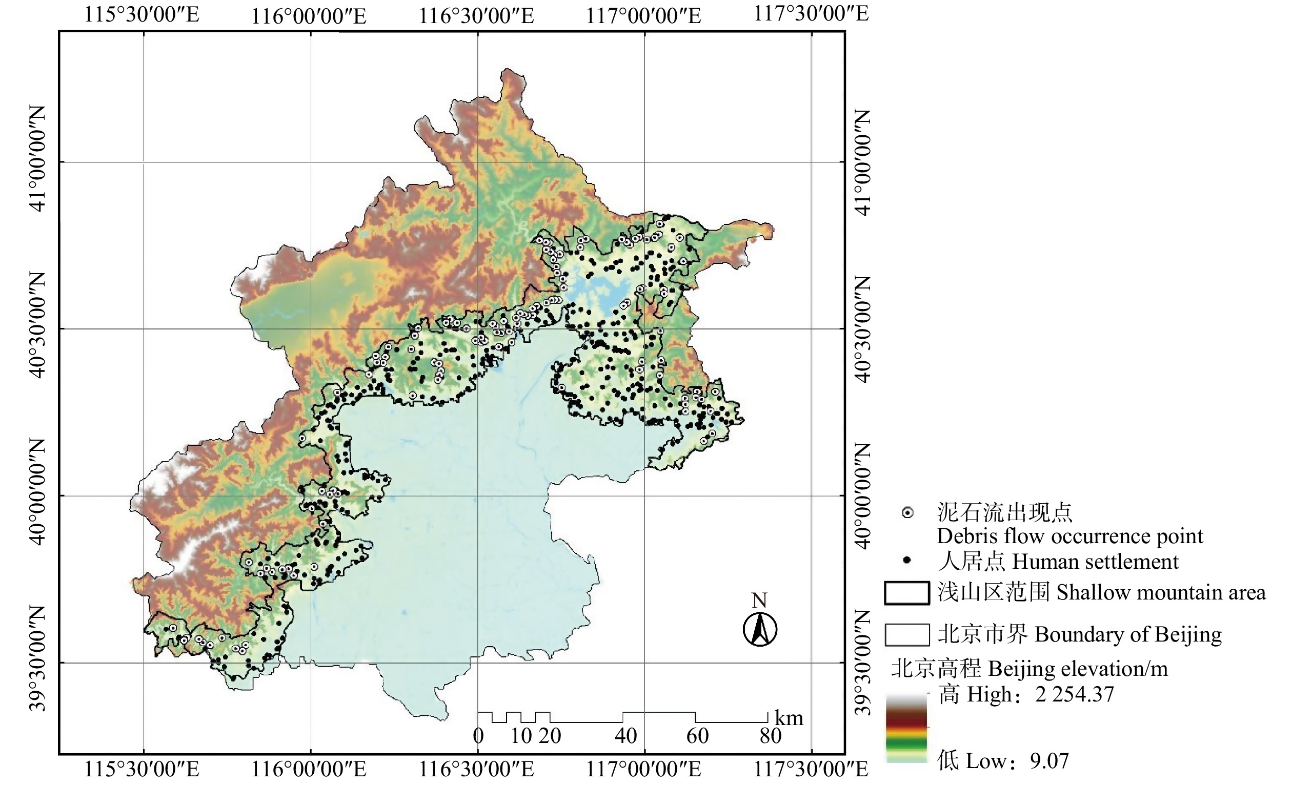
图 1 北京浅山区人居点和泥石流历史灾害点分布
Figure 1. Distribution of human settlements and historical debris flow occurrence points in the shallow mountain area of Beijing
![]()
图 3 基于增强人居环境泥石流抵抗力的造林选址
Figure 3. Afforestation area selection based on enhancing the resistance of debris flow of human settlements
![]()
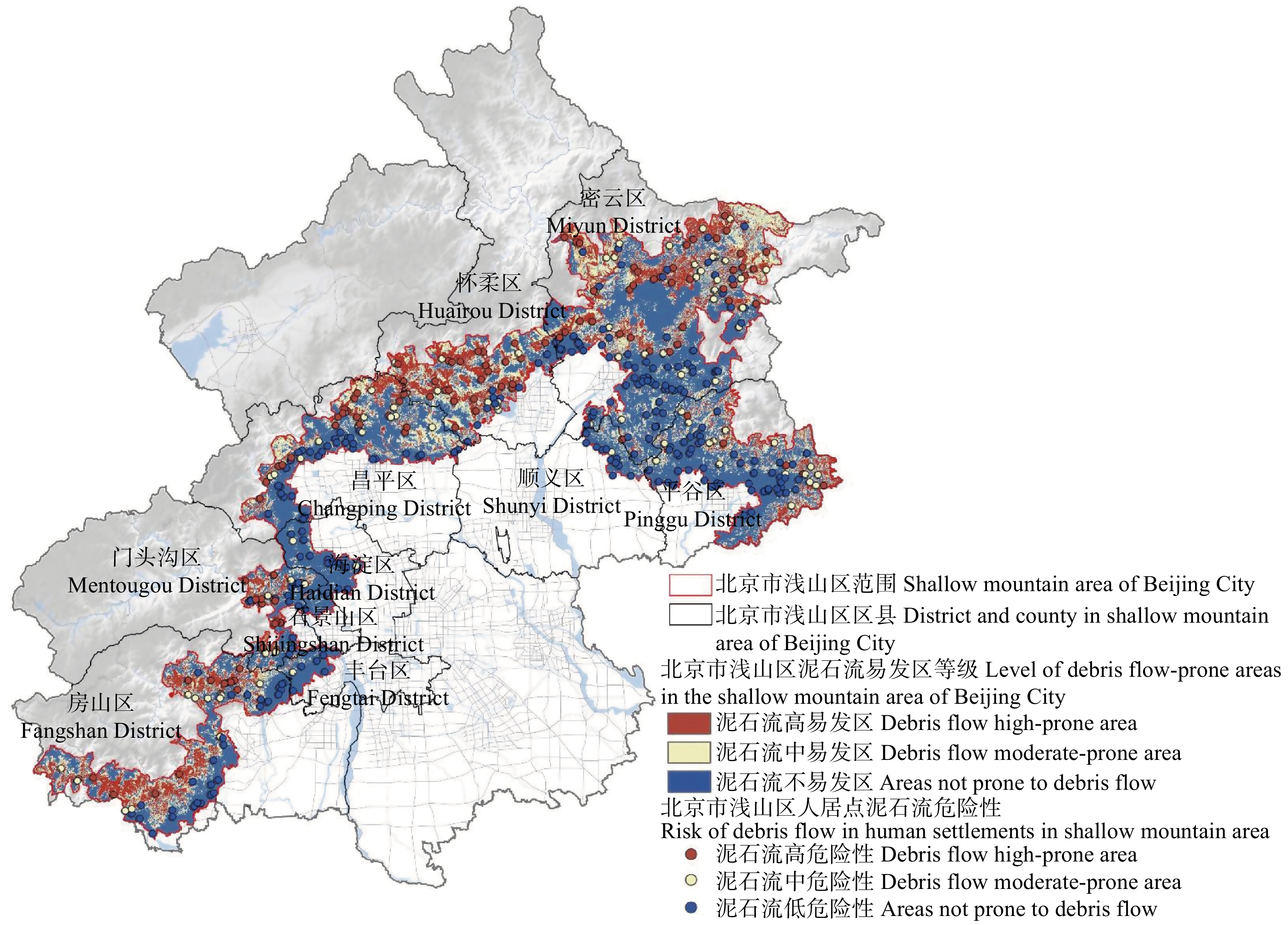
图 4 现状研究范围内泥石流易发等级分布以及人居点泥石流危险性
Figure 4. Distribution of debris flow prone area and the debris flow risk of human settlements before afforestation
![]()
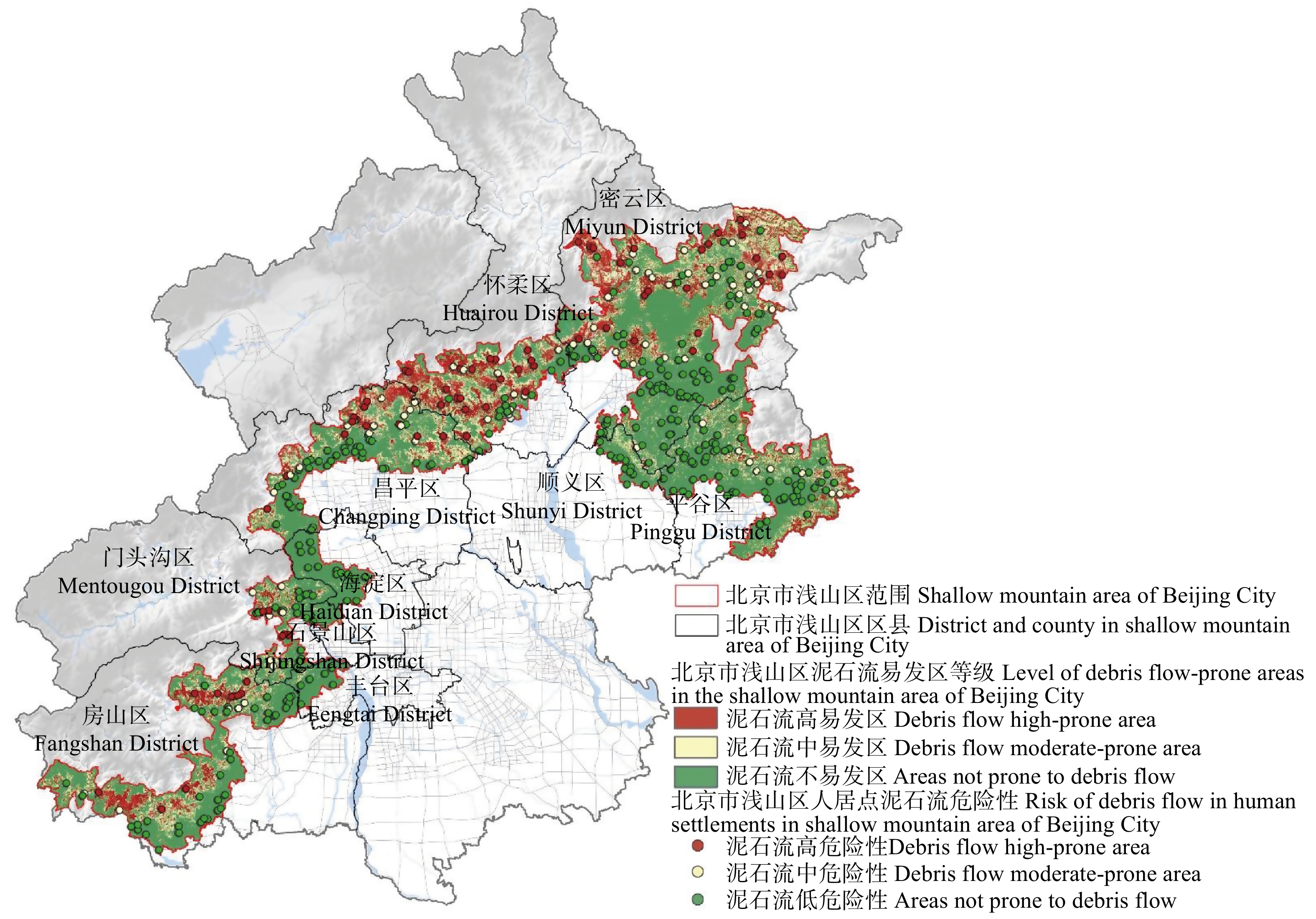
图 5 造林后研究范围内泥石流易发等级分布以及人居点泥石流危险性
Figure 5. Distribution of debris flow prone area and the debris flow risk of human settlements after afforestation
表 1 数据名称及来源
Table 1 Data name and source
序号
No.数据名称
Data name数据来源
Data source1 泥石流出现点
Debris flow occurrence point北京市国土资源局2016年山地灾害统计
Statistics of mountain disasters by Beijing Municipal Bureau of Land and Resources in 20162 人居点/道路数据/河流数据
Human settlement, road data, river data国家测绘地理信息局
National Bureau of Surveying, Mapping and Geographic Information3 气象数据 Meteorological data 国家气象科学数据中心 National Meteorological Science Data Center 4 高程/坡度/坡向/地形起伏度数据
Elevation, slope degree, slope aspect, terrain relief degree data地理空间数据云平台/GIS处理
Geospatial Data Cloud, GIS processing5 基岩岩性/断裂带 Bedrock lithology/fault zone 《北京山洪泥石流》 Beijing Mountain Torres and Debris Flow 6 土壤类型数据 Soil type data 中国土壤数据库 China Soil Database 7 土地利用数据 Land use data 地理空间数据云平台/ENVI解译 Geospatial data cloud, ENVI interpretation  下载: 导出CSV
表 2 12个环境变量之间的相关系数
Table 2 Correlation coefficients among 12 environmental variables
项目
Item年均降
雨量
Average
annual
rainfall最湿季
降雨量
Wettest
season
rainfall地形
起伏度
Terrain
relief
degree
(RDLS)坡向
Slope
aspect坡向
变化率
Slope
aspect
change
rate (SOA)基岩岩性
Bedrock
lithology断裂带
密度
Density of
fracture
zone土壤
类型
Soil
type河网密度
River
network
density林地分布
Woodland
distribution距人居点
距离
Distance to
human
settlement距道路
距离
Distance
to road年均降雨量
Average annual rainfall1 最湿季降雨量
Wettest season rainfall−0.098 1 地形起伏度 RDLS 0.295 −0.051 1 坡向 Slope aspect −0.001 0.007 −0.028 1 坡向变化率 SOA −0.035 0.003 −0.198 0.059 1 基岩岩性
Bedrock lithology−0.278 −0.137 −0.138 −0.010 0.047 1 断裂带密度
Density of fracture zone−0.177 0.168 0.029 0.013 −0.022 0.126 1 土壤类型 Soil type −0.045 −0.037 −0.075 −0.070 −0.072 0.102 0.045 1 河网密度
River network density0.094 0.057 0.253 0.046 −0.033 −0.152 0.080 −0.233 1 林地分布
Woodland distribution0.133 −0.155 0.338 −0.033 −0.102 −0.119 −0.069 −0.104 0.139 1 距人居点距离
Distance to human settlement0.172 −0.030 0.324 −0.016 −0.163 0.030 0.068 0.230 0.038 0.109 1 距道路距离
Distance to road0.274 −0.114 0.382 −0.011 −0.140 −0.002 0.001 0.242 0.051 0.130 0.532 1
下载: 导出CSV
表 3 泥石流敏感性模拟选取因子
Table 3 Variables selected for the simulation of debris flow susceptibility
编号
No.1 2 3 4 5 6 因子名称
Factor name年均降雨量
Average annual rainfall最湿季降雨量
Wettest season rainfall地形起伏度
RDLS坡向
Slope aspect坡向变化率
SOA基岩岩性
Bedrock lithology编号
No.7 8 9 10 11 12 因子名称
Factor name断裂带密度
Density of fracture zone土壤类型
Soil type河网密度
River network density林地分布
Woodland distribution距人居点距离
Distance to human settlement距道路距离
Distance to road
下载: 导出CSV
表 4 人居环境安全视角下的泥石流防灾林选址综合评价体系
Table 4 Evaluation system for site selection of debris flow disaster prevention forest from the perspective of human settlement security
因子类型
Factor type评价指标
Evaluation index指标分级
Index rating评分
Score指标权重
Index weight风险因子
Risk factor泥石流敏感性
Debris flow susceptibility高适宜性(高易发区)
High suitability (high prone area)10 0.388 中适宜性(中易发区)
Medium suitability (medium prone area)6 低适宜性(不易发区)
Low suitability (not prone area)2 环境因子
Environmental factor人居点与泥石流流域内各区域关系
Relationship between human settlement and various area in the debris flow catchment basin人居点上游泥石流清水区
Debris flow catchment area upstream of human settlement10 0.421 人居点上游的泥石流物源区
Debris flow forming area upstream of human settlement8 其他区域
Other area2 造林可行性因子
Feasibility factor of afforestation距道路距离
Distance to road高适宜性(0 ~ 500 m)
High suitability (0−500 m)10 0.072 中适宜性(500 ~ 2 000 m)
Moderate suitability (500−2 000 m)6 低适宜性(> 2 000 m)
Low suitability (> 2 000 m)2 坡度适宜性
Slope degree suitability高适宜性(0° ~ 15°)
High suitability (0°−15°)10 0.087 中等适宜性(15° ~ 30°)
Moderate suitability (15°−30°)6 低适宜性(> 30°)
Low suitability (> 30°)1 用地转换林地适宜性
Suitability of land conversion to woodland高适宜性(草地、园地)
High suitability (grassland, garden plot)10 0.032 中适宜性(一般农田、其他用地)
Moderate suitability (general farmland, other land)4 低适宜性(城镇村、工矿、交通运输、水域及水利设施用地)
Low suitability (urban and villages, industrial and mining, transportation, water area and water conservancy facility land)1
下载: 导出CSV
表 5 造林前后泥石流敏感性评价
Table 5 Susceptiblity evaluation of debris flow before and after afforestation
泥石流敏感性等级
Susceptibility level of
debris flow现状面积
Current
area/km2造林后面积
Area after
afforestation/km2面积变化
Area change/
km2现状面积占比
Proportion of
current area/%造林后面积占比
Proportion of
area after
afforestation/%面积占比变化
Change of area
proportion/%泥石流高易发区
Debris flow high-prone area689.04 653.80 −35.24 17.6 16.7 −0.9 泥石流中易发区
Debris flow moderate-prone area1 041.39 959.18 −82.21 26.6 24.5 −2.1 泥石流不易发区
Areas not prone to debris flow2 184.57 2 302.02 +117.45 55.8 58.8 +3.0 小计 Total 3 915.00 3 915.00 0 100 100 0
下载: 导出CSV
表 6 造林前后人居点泥石流危险性评价
Table 6 Risk assessment of debris flow in human settlements before and after afforestation
人居点泥石流敏感性等级
Susceptibility of debris flow
in human settlement现状人
居点个数
Number of
current
settlement造林后人
居点个数
Number of
settlement after
afforestation人居点
数量变化
Quantity change
of settlement现状人
居点占比
Proportion of
current
settlement/%造林后人
居点占比
Proportion of
settlement after
afforestation/%人居点
占比变化
Change of
settlement
proportion/%泥石流高易发区
Debris flow high-prone area119 75 −44 26.7 16.8 −9.9 泥石流中易发区
Debris flow moderate-prone area87 80 −7 19.6 18.0 −1.6 泥石流不易发区
Areas not prone to debris flow239 290 +51 53.7 65.2 +11.5 小计 Total 445 445 0 100 100 0
下载: 导出CSV
-
[1] 张新伟, 王建西. 浅谈地质灾害隐患点辨识及数值模拟分析: 以北京山区典型区域为例[J]. 城市地质, 2019, 14(4):72−76. Zhang X W, Wang J X. Study on identification and numerical simulation analysis for potential geological hazards-taking Beijing typical mountainous area as an example[J]. Urban Geology, 2019, 14(4): 72−76.
[2] 倪化勇, 唐川. 中国泥石流起动物理模拟试验研究进展[J]. 水科学进展, 2014, 25(4):606−613. Ni H Y, Tang C. Advances in the physical simulation experiment on debris flow initiation in China[J]. Advances in Water Science, 2014, 25(4): 606−613.
[3] Reichenbach P, Rossi M, Malamud B D, et al. A review of statistically-based landslide susceptibility models[J]. Earth-Science Reviews, 2018, 180: 60−91. doi: 10.1016/j.earscirev.2018.03.001
[4] 刘希林. 国外泥石流机理模型综述[J]. 灾害学, 2002,17(4):2−7. Liu X L. An overview of foreign debris flow mechanism models[J]. Journal of Catastrophology, 2002,17(4): 2−7.
[5] 王晓朋, 潘懋, 任群智. 基于流域系统地貌信息熵的泥石流危险性定量评价[J]. 北京大学学报(自然科学版), 2007, 43(2):211−215. Wang X P, Pan M, Ren Q Z. Hazard assessment of debris flow based on geomorphic information entropy in catchment[J]. Acta Scientiarum Naturalium Universitatis Pekinensis, 2007, 43(2): 211−215.
[6] 齐信, 唐川, 铁永波, 等. 基于GIS技术的汶川地震诱发地质灾害危险性评价: 以四川省北川县为例[J]. 成都理工大学学报(自然科学版), 2010, 37(2):160−167. Qi X, Tang C, Tie Y B, et al. Hazard assessment of geohazards triggered by the Wenchuan earthquake using GIS technology: Taking Beichuan County of Sichuan Province for example[J]. Journal of Chengdu University of Technology (Science & Technology Edition), 2010, 37(2): 160−167.
[7] 倪树斌, 马超, 杨海龙, 等. 北京山区崩塌、滑坡、泥石流灾害空间分布及其敏感性分析[J]. 北京林业大学学报, 2018, 40(6):81−91. Ni S B, Ma C, Yang H L, et al. Spatial distribution and susceptibility analysis of avalanche, landslide and debris flow in Beijing mountain region[J]. Journal of Beijing Forestry University, 2018, 40(6): 81−91.
[8] 于秀治, 韦京莲. 灰色系统理论在北京山区泥石流危险度评价预测中的应用[J]. 中国地质灾害与防治学报, 2004,15(1):121−123. doi: 10.3969/j.issn.1003-8035.2004.01.026 Yu X Z, Wei J L. Grey system analysis and its application in the forecast of mud-rock flow criticality of Beijing[J]. The Chinese Journal of Geological Hazard and Control, 2004,15(1): 121−123. doi: 10.3969/j.issn.1003-8035.2004.01.026
[9] 王子健, 肖盛燮, 戴廷利, 等. 泥石流危险度模糊综合评判方法及应用[J]. 重庆交通大学学报(自然科学版), 2008,27(5):794−798. Wang Z J, Xiao S X, Dai T L, et al. Fuzzy comprehensive evaluation method and its application in judging the risk degree of debris flows[J]. Journal of Chongqing Jiaotong University (Natural Science), 2008,27(5): 794−798.
[10] Chen W, Xie X, Wang J, et al. A comparative study of logistic model tree, random forest, and classification and regression tree models for spatial prediction of landslide susceptibility[J]. Catena, 2017, 151: 147−160. doi: 10.1016/j.catena.2016.11.032
[11] 刘涌江, 胡厚田, 白志勇. 泥石流危险度评价的神经网络法[J]. 地质与勘探, 2001,11(2):84−87. Liu Y J, Hu H T, Bai Z Y. Artificial neural network method for evaluating the dangerous degree of debris flows[J]. Geology and Prospecting, 2001,11(2): 84−87.
[12] Catani F, Lagomarsino D, Segoni S, et al. Landslide susceptibility estimation by random forests technique: sensitivity and scaling issues[J]. Natural Hazards and Earth System Sciences, 2013, 13(11): 2815−2831. doi: 10.5194/nhess-13-2815-2013
[13] Shirvani Z. A holistic analysis for landslide susceptibility mapping applying geographic object-based random forest: a comparison between protected and non-protected forests[J]. Remote Sensing, 2020, 12(3): 434. doi: 10.3390/rs12030434
[14] Xiong K, Adhikari B R, Stamatopoulos C A, et al. Comparison of different machine learning methods for debris flow susceptibility mapping: a case study in the Sichuan Province, China[J]. Remote Sensing, 2020, 12(2): 295. doi: 10.3390/rs12020295
[15] 田丰, 张军, 冉有华, 等. 甘肃陇南市泥石流灾害危险性及影响因子评价[J]. 灾害学, 2017, 32(3):197−203. doi: 10.3969/j.issn.1000-811X.2017.03.033 Tian F, Zhang J, Ran Y H, et al. Assessment of debris flow disaster hazard and influence factors in Longnan District[J]. Journal of Catastrophology, 2017, 32(3): 197−203. doi: 10.3969/j.issn.1000-811X.2017.03.033
[16] Lombardo L, Bachofer F, Cama M, et al. Exploiting maximum entropy method and ASTER data for assessing debris flow and debris slide susceptibility for the Giampilieri catchment (northeastern Sicily, Italy)[J]. Earth Surface Processes and Landforms, 2016, 41(12): 1776−1789. doi: 10.1002/esp.3998
[17] Mercer J, Gaillard J C, Crowley K, et al. Culture and disaster risk reduction: lessons and opportunities[J]. Environmental Hazards, 2012, 11(2): 74−95. doi: 10.1080/17477891.2011.609876
[18] Sandholz S, Lange W, Nehren U. Governing green change: Ecosystem-based measures for reducing landslide risk in Rio de Janeiro[J]. International Journal of Disaster Risk Reduction, 2018, 32: 75−86. doi: 10.1016/j.ijdrr.2018.01.020
[19] Booth A M, Sifford C, Vascik B, et al. Large wood inhibits debris flow runout in forested southeast Alaska[J]. Earth Surface Processes and Landforms, 2020, 45(7): 1555−1568. doi: 10.1002/esp.4830
[20] Lancaster S T, Hayes S K, Grant G E. Effects of wood on debris flow runout in small mountain watersheds[J]. Water Resources Research, 2003, 39(6): 1−17.
[21] Michelini T, Bettella F, D’Agostino V. Field investigations of the interaction between debris flows and forest vegetation in two Alpine fans[J]. Geomorphology, 2017, 279: 150−164. doi: 10.1016/j.geomorph.2016.09.029
[22] Coelho-Netto A L, Avelar A S, Fernandes M C, et al. Landslide susceptibility in a mountainous geoecosystem, Tijuca Massif, Rio de Janeiro: the role of morphometric subdivision of the terrain[J]. Geomorphology, 2007, 87(3): 120−131.
[23] McVittie A, Cole L, Wreford A, et al. Ecosystem-based solutions for disaster risk reduction: lessons from European applications of ecosystem-based adaptation measures[J]. International Journal of Disaster Risk Reduction, 2018, 32: 42−54. doi: 10.1016/j.ijdrr.2017.12.014
[24] García-Feced C, Saura S, Elena-Rosselló R. Improving landscape connectivity in forest districts: a two-stage process for prioritizing agricultural patches for reforestation[J]. Forest Ecology and Management, 2011, 261(1): 154−161. doi: 10.1016/j.foreco.2010.09.047
[25] Hu W, Wang Y, Dong P, et al. Predicting potential mangrove distributions at the global northern distribution margin using an ecological niche model: determining conservation and reforestation involvement[J]. Forest Ecology and Management, 2020, 478: 118517. doi: 10.1016/j.foreco.2020.118517
[26] Cimini D, Portoghesi L, Madonna S, et al. Multifactor empirical mapping of the protective function of forests against landslide occurrence: statistical approaches and a case study[J]. iForest-Biogeosciences and Forestry, 2016, 9(3): 383. doi: 10.3832/ifor1740-008
[27] Moos C, Fehlmann M, Trappmann D, et al. Integrating the mitigating effect of forests into quantitative rockfall risk analysis: two case studies in Switzerland[J]. International Journal of Disaster Risk Reduction, 2018, 32: 55−74. doi: 10.1016/j.ijdrr.2017.09.036
[28] 张嫱, 马超, 杨海龙, 等. 北京山区典型低频泥石流特征及危险性研究[J]. 北京林业大学学报, 2015, 37(12):92−99. Zhang Q, Ma C, Yang H L, et al. Characteristics of low frequency debris flow and risk analysis in Beijing mountainous region[J]. Journal of Beijing Forestry University, 2015, 37(12): 92−99.
[29] 周亮, 徐建刚, 林蔚, 等. 秦巴山连片特困区地形起伏与人口及经济关系[J]. 山地学报, 2015, 33(6):742−750. Zhou L, Xu J G, Lin W, et al. Relationship of terrain relief degree and population economic development and evaluation of development suitability in continuous poor areas[J]. Mountain Research, 2015, 33(6): 742−750.
[30] 张成奇, 王喜琴, 王喜生. 浅析预防地质灾害防灾林的设计与创新[J]. 农家参谋, 2019(19):113. Zhang C Q, Wang X Q, Wang X S. Analysis on the design and innovation of disaster prevention forest to prevent geological disasters[J]. The Farmers Consultant, 2019(19): 113.
[31] 余新晓, 秦永胜, 陈丽华, 等. 北京山地森林生态系统服务功能及其价值初步研究[J]. 生态学报, 2002, 22(5):783−786. Yu X X, Qin Y S, Chen L H, et al. The forest ecosystem services and their valuation of Beijing mountain areas[J]. Acta Ecologica Sinica, 2002, 22(5): 783−786.
[32] 倪畅, 周凯, 郑曦. 基于景观生态风险评价的景观格局优化:以北京市浅山区为例[J]. 风景园林, 2021, 28(5):80−85. Ni C, Zhou K, Zheng X. Landscape pattern optimization based on landscape ecological risk assessment: a case study of shallow mountain area in Beijing[J]. Landscape Architecture, 2021, 28(5): 80−85.
-
期刊类型引用(0)
其他类型引用(4)


计量
- 文章访问数: 1033
- HTML全文浏览量: 292
- PDF下载量: 47
- 被引次数: 4
