
Spatio-temporal variation of ecosystem service value based on LUCC trajectories: a case study of Bosten Lake Watershed
-
摘要:目的 为了更好地揭示生态系统服务价值时空变化特征及趋势,加强对生态系统服务价值(ESV)空间变化描述。方法 该研究以博斯腾湖流域为例,结合使用逐像元的追踪分析、趋势分析等方法,试探究土地利用/覆盖变化(LUCC)对生态系统服务价值的影响。结果 (1)博斯腾湖流域主要的土地利用类型是荒漠,其次是草甸和裸地。研究期内,水田、荒漠、草甸、湿地、水域、旱地、建设用地面积增加;草原、灌木、裸地、针叶、阔叶、冰川积雪面积减少,2005—2010年综合土地利用动态度最大。(2)2000—2018年博斯腾湖流域未发生变化的土地即稳定型占流域总面积的60.43%,中等变化型、回归型和激烈变化型多分布于人类活动较强的绿洲地区。(3)2000—2018年博斯腾湖流域ESV总体上呈现波动增长趋势,流域ESV主要由草甸、水域和湿地构成,水域、旱地、草甸和草原是流域ESV变化的主要贡献因子和敏感因子,其中草原为负向贡献因子。(4)博斯腾湖流域ESV呈西北高、东南低,高值(博斯腾湖)点缀在低值区的空间分布特征。有明显增大与明显减少趋势的地区均分布于博斯腾湖周围湿地,流域北部大部分ESV呈轻度增加趋势,绿洲区轨迹等级和ESV变化趋势从城市至绿洲边缘呈:中等变化型(ESV轻度减少)— 渐变型(ESV轻度增加)— 中等变化型(ESV轻度减少)环状相间结构。结论 该研究发现博斯腾湖流域南部土地利用轨迹等级、ESV变化趋势均高于北部的空间差异,并采用土地利用追踪分析与ESV趋势变化相结合的方式,揭示了绿洲城市的土地利用冲突现状及ESV时空变化,对博斯腾湖流域土地利用调控和生态环境保护提供参考。Abstract:Objective The research on the impact of land use change and ecosystem service value under the background of global warming and increasing human vitality has become a hot topic in the current ecosystem change research. This paper aims to reveal the spatio-temporal variation characteristics and trends of ecosystem service value and facilitate to the traditional spatial statistical methods such as hot spot analysis to describe the insignificant fluctuation in ecosystem service value (ESV).Method In this study, pixel based tracking analysis, trend analysis and other methods were combined to test the impact of LUCC (land use and land cover change) on ESV in the Bosten Lake Watershed.Result (1) Desert was the predominant land use type in the Bosten Lake Watershed, followed by meadow and bare land. During the study period, the area of paddy field, desert, meadow, wetland, water area, dry land and construction land showed increasing trend. Grassland, shrubland, bare land, coniferous, broadleaf, glacier snow showed decreasing trend, from 2005–2010, the dynamic level of comprehensive land use was most significant. (2) From 2000 to 2018, the stable type accounted for 60.43% of the total area in the Bosten Lake Watershed, and the moderate change type, regression type and intense change type were mainly distributed in the oasis areas owing to intense human activities. (3) From 2000 to 2018, the ESV of the Bosten Lake Watershed showed a fluctuating growth trend. The ESV of the watershed was mainly composed of meadows, water area and wetlands. Water area, dry land, meadow and grassland were the main contributors and sensitive factors of ESV changes in the watershed, besides, grassland was negative contributing factor. (4) The ESV of the Bosten Lake Watershed was higher in the northwest than in the southeast, with high values (Bosten Lake) dotted in the low-value areas. The areas of significant increasing and decreasing trends were mainly distributed in the wetland around Bosten Lake. ESV in the northern part of the basin showed a slight increasing trend. The trajectory level and ESV change trend of the oasis area from the city to the edge of the oasis as ranked: medium change type (slightly decreased ESV)-gradient type (slightly increased ESV)-moderate variation type (slightly decreased ESV) ring-shaped interphase structure.Conclusion This study demonstrates that the spatial difference of land use trajectory level and ESV change trend in the southern part are higher than in the northern part, combination of land use tracking analysis and the ESV trend change reveal the current status of land use conflicts and model distribution of the ESV spatiotemporal changes in oasis cities, provides a reference for land use management and ecological environment protection in the Bosten Lake Watershed.
-
生态系统服务是指生态系统在物质循环和能量转换过程中直接或间接促进人类发展的生态系统产品和生态系统功能[1]。联合国千年生态系统评估计划指出,近一百多年来全球60%的生态系统正在或已经退化[2],其主要原因是对生态系统服务价值的认识不足导致的盲目开发[3]。土地利用/覆盖变化(land use and land cover change,LUCC)是人类活动作用于生态系统的主要方式[4],在改变生态系统格局和过程的同时,对生态系统产品与服务提供能力产生不同程度的影响[5-6],具有较强的空间差异性。评估LUCC对生态系统服务价值(ecosystem services value,ESV)的影响,有利于全面认识生态环境时空变化特征,可为土地利用格局优化和生态建设提供决策依据[7]。
1997年Costanza等[8]构建了“全球生态系统服务价值当量表”及“全球生态服务价值分析模型”,奠定了生态系统服务价值研究的理论基础,同年Daily[9]发表的专著论述了生态系统服务功能的概念、价值评估等。2003年谢高地等[10]根据Costanza的方法提出了符合中国国情的当量因子表并确立了中国单位面积价值当量及计算,国内众多学者据此在不同尺度上对流域[11]、湖泊[12]、城市(群)[13-14]、绿洲[15]、岛屿[16]等生态系统服务价值进行了评估;研究内容涉及生态系统服务价值的定量化计算与修正[17-18]、生态系统尺度响应研究[19]、生态系统服务价值驱动力分析[20]、不同情景下的未来生态系统服务价值预测[21]等方面。目前国内外关于LUCC对ESV影响,刻画其地理分布规律特征、ESV空间差异性研究等方面取得了较为丰富的成果[22-25],但对LUCC的大多研究只关注一种类型向另一类型的转换,忽略了土地利用变化的复杂序列。土地利用时间序列追踪分析[26]克服了双时向无法探测中间过程的不足,能有效揭示土地利用变化的轨迹和过程[27-28]。趋势分析方法逐像元描述ESV的变化趋势,能反应ESV空间总体变化趋势,本文试用追踪分析和趋势分析对博斯腾湖流域的LUCC过程和ESV时空演变进行分析,并且将两者结合来探讨LUCC对ESV的空间差异影响。
随着改革开放及西部大开发的进程,博斯腾湖流域人口激增,经济快速发展,城市化、畜牧数量攀升等问题使得森林、草地被城市和农田占用,绿洲区也出现了荒漠化,并且伴随着水质退化、土地盐碱化等问题。因此,博斯腾湖流域生态环境和资源配置问题亟待解决。本文基于博斯腾湖流域2000—2018年土地利用数据,拟采用逐像元趋势分析方法,结合土地利用时间序列追踪分析,利用土地利用转移矩阵、ESV损益流向表,旨在分析:(1)近20年来博斯腾湖流域土地利用数量变化特征及LUCC过程在空间上的分布;(2)研究区生态系统服务价值结构、损益特征;(3)流域内LUCC对ESV的空间差异性的影响。
1. 研究区概况
博斯腾湖流域位于中国西北部新疆巴音郭楞蒙古自治州境内,是典型的干旱区山地−绿洲−荒漠陆面格局,属于温带大陆性干旱气候,日照时间长、气候较干燥、降水量稀少及蒸散发高于降水量,流域大部分区域植被覆盖率较低,生态系统易受气候变化的影响且极为脆弱,行政区划包括和硕县、和静县、焉耆县、博湖县、轮台县(部分)、库尔勒市、铁门关市(原新疆生产建设兵团第二师)以及尉犁县的部分区域(图1),流域总面积约79 204.25 km2。博斯腾湖串联着开都河与孔雀河,是绿洲农业生产、城市发展、人民生活的重要水源供给[29],也是塔里木河“生态输水”水源地,流入博斯腾湖的河流主要是开都河,其次有清水河、黄水沟等,流出博斯腾湖的河流只有孔雀河。流域内地势呈西北高、东南低,海拔高度在860 ~ 4 739 m之间,流域景观随海拔高度自上到下包括冰川积雪带、高山草甸带、草原带、绿洲平原、荒漠草原带和荒漠带等。
2. 数据来源与研究方法
2.1 数据来源
土地利用分类数据来源于中国科学院资源环境科学数据中心(http://www.resdc.cn),解译精度达90%以上,空间分辨率为30 m,该系列数据将土地利用类型划分为6个一级分类和25个二级分类。本文根据分类标准、含义、博斯腾湖流域土地类型特点以及谢高地等[30]生态系统分类体系将其重分类为旱地、水田、灌木、草原、草甸、湿地、荒漠、裸地、水域、冰川积雪等12个生态系统类型。博斯腾湖流域的粮食作物播种面积及产量数据来源于《新疆统计年鉴》《新疆生产建设兵团统计年鉴》;粮食价格数据来源于《全国农产品成本收益资料汇编2019》。
2.2 研究方法
2.2.1 土地利用变化分析
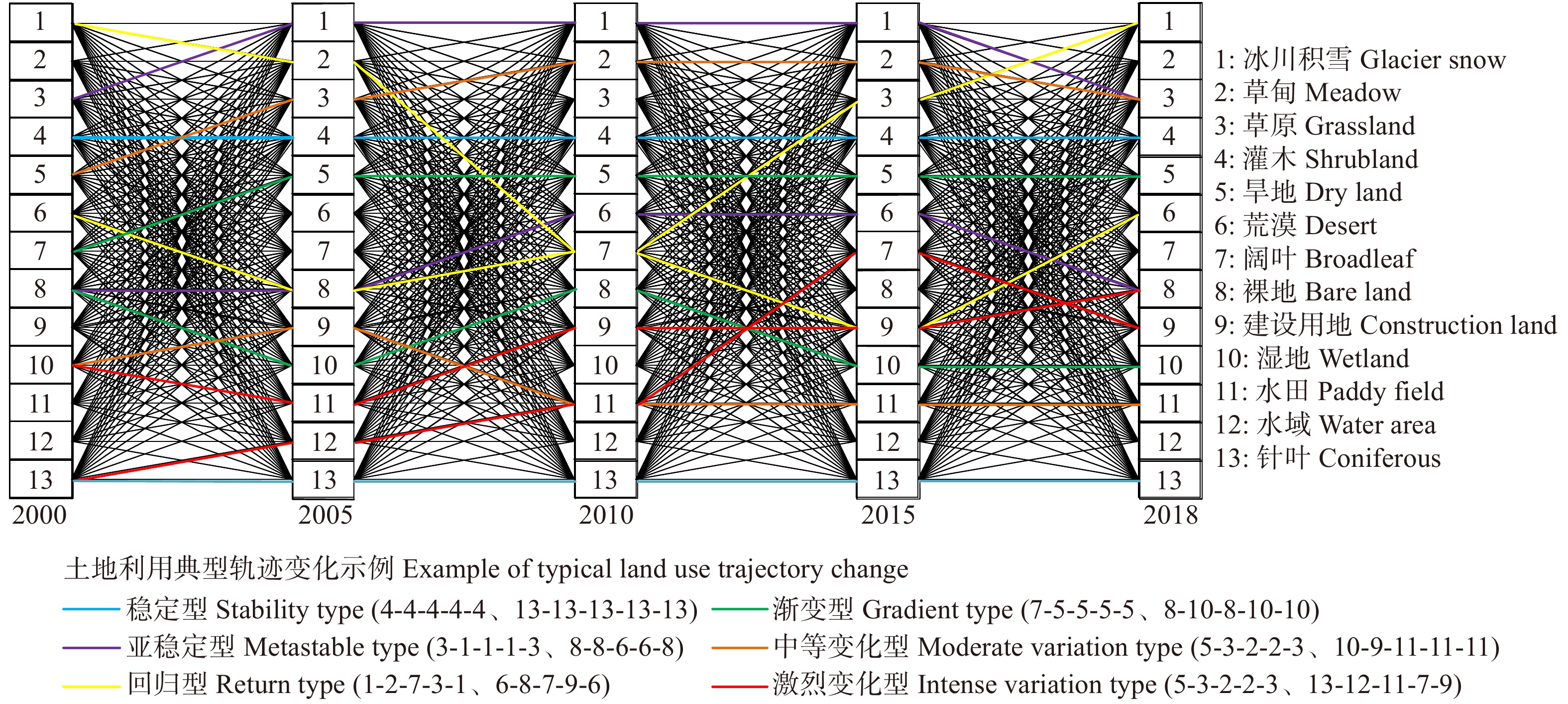
(1)土地利用追踪分析。在一定的时间段内,分析像元内所有土地利用类型变化轨迹即为土地利用追踪分析,该方法可以弥补双时相变化检测无法探测中间过程的不足,揭示LUCC过程在空间上的分异规律[31]。所有可能的LUCC变化轨迹如图2。为了定量分析LUCC时空变化图谱,根据变化轨迹初末期是否改变、过程的剧烈程度,并参考相关文献将变化轨迹划分为6类[32],赋予追踪变化等级。当某像元的初末期LUCC未改变,可根据中间变化过程的地类状况将其分为4种轨迹类型:中间变化为0,即中间地类未发生变化,则为稳定型(Ⅰ级);中间变化为1,即出现了一种新的地类,则为亚稳定型(Ⅱ级);中间变化为2或大于2,即出现了两种或两种以上新的地类,则为回归型(Ⅲ级)。当某像元的初末期LUCC发生改变,亦可根据中间变化过程的变化状况将其分为3种轨迹类型:中间过程的地类为初期或末期的地类,则为渐变型(Ⅳ级);中间过程的地类除了初期或末期的地类,出现1种新的地类时,则为中等变化型(Ⅴ级);中间过程的地类除了初期或末期的地类,出现2种或2种以上新的地类时,则为激烈变化型(Ⅵ级)。
![]() 图 2 2000—2018年博斯腾湖流域所有可能的LUCC变化轨迹及典型例子Figure 2. All possible LUCC change trajectories and examples in Bosten Lake Watershed from 2000 to 2018
图 2 2000—2018年博斯腾湖流域所有可能的LUCC变化轨迹及典型例子Figure 2. All possible LUCC change trajectories and examples in Bosten Lake Watershed from 2000 to 2018(2)土地利用转移矩阵可以对研究区各地类初期和末期的面积和转移进行定量描述,分析各土地利用类型之间的转移过程和方向[33]。
各土地利用类型的变化速率与幅度可以用土地利用动态度表示,单一土地利用动态度计算公式如下[31]:
D=Ub−UaUa×1T×100% (1) 式中:D为某一土地利用类型动态度;研究期初地类面积用
Ua 表示,研究期末地类面积用Ub 表示;T为变化年份。综合土地利用动态度计算公式如下[34]:
LC=[n∑i=1ΔLUi−j2n∑i=1LUi]×1T×100% (2) 式中:LC为综合土地利用动态度;
n = 13;i和j代表土地利用类型;LUi 为研究期初第i 类土地利用类型面积;ΔLUi−j 为监测时段内第i类土地利用类型转为j类土地利用类型的面积。2.2.2 生态系统服务价值评估方法
ESV评估方法多样,由于功能价格法输入参数较多、参数标准难以统计,本文选用直观易用的当量因子法[35]对博斯腾湖流域生态系统服务价值进行估算。博斯腾湖流域平均粮食产量是新疆平均粮食产量的1.001倍,根据区域修正系数表(新疆为0.58)对生态系统服务价值进行修正[36]。2000—2018年博斯腾湖流域平均粮食产量为6 539.58 kg/hm2,2018年新疆平均粮食价格为1.98元/kg,计算出博斯腾湖流域生态系统服务价值当量因子为1 092.45元/hm2,与当量表相乘得出博斯腾湖流域生态系统单位面积服务价值系数表(表1)。通过公式(3)和公式(4)计算博斯腾湖流域生态系统服务价值。
表 1 博斯腾湖流域生态系统服务价值系数表 元/(hm2·a)Table 1. Coefficients of the ecosystem service value in Bosten Lake WatershedCNY/(ha·year) 一级类型
First category供给服务
Provisioning service调节服务
Regulating service支持服务
Supporting service文化服务
Cultural service二级分类
Second category食物生产
Food production原料生产
Material production水资源
供给
Water
supply气体调节
Gas regulation气候调节
Climate regulation净化环境
Purify environment水文调节
Hydrological adjusting土壤保持
Soil conservation维持
养分循环
Maintaining
nutrient cycling生物
多样性
Biodiversity美学景观
Aesthetic landscapeDL 928.59 436.98 21.85 731.94 393.28 109.25 294.96 1 125.23 131.09 142.02 65.55 PF 1 485.74 98.32 −2 873.15 1 212.62 622.70 185.72 2 971.47 10.92 207.57 229.42 98.32 C 240.34 568.08 294.96 1 857.17 5 538.74 1 627.76 3 648.80 2 250.45 174.79 2 053.81 895.81 B 316.81 721.02 371.43 2 370.62 7 100.95 2 108.44 5 178.23 2 895.00 218.49 2 632.81 1 158.00 S 207.57 469.76 240.34 1 540.36 4 621.08 1 398.34 3 659.72 1 879.02 142.02 1 715.15 753.79 G 109.25 152.94 87.40 557.15 1 463.89 480.68 1 070.60 677.32 54.62 611.77 273.11 M 240.34 360.51 196.64 1 245.40 3 299.21 1 092.45 2 414.32 1 518.51 120.17 1 387.42 611.77 W 557.15 546.23 2 829.45 2 075.66 3 932.83 3 932.83 26 470.15 2 523.57 196.64 8 597.61 5 167.31 D 10.92 32.77 21.85 120.17 109.25 338.66 229.42 142.02 10.92 131.09 54.62 BL 0.00 0.00 0.00 21.85 0.00 109.25 32.77 21.85 0.00 21.85 10.92 WA 873.96 251.26 9 056.44 841.19 2 501.72 6 063.12 111 692.46 1 015.98 76.47 2 785.76 2 064.74 GS 0.00 0.00 2 359.70 196.64 589.92 174.79 7 789.19 0.00 0.00 10.92 98.32 注:GS代表冰川积雪;M代表草甸;G代表草原;S灌木;DL代表旱地;D代表荒漠;B代表阔叶;BL代表裸地;W代表湿地;PF代表水田;WA代表水域;C代表针叶。Notes: GS means glacier snow; M means meadow; G means grassland; S means shrubland; DL means dry land; D means desert; B means broadleaf; BL means bare land; W means wetland; PF means paddy field; WA means water area; C means coniferous. ESV=n∑i=1(Aj×VCj) (3) ESVf=n∑i=1(Aj×VCjs) (4) 式中:
ESV 为生态系统服务总价值,ESVf 是第f 项服务功能价值;s 为某一生态系统服务类型;Aj 代表地类j 的面积(hm2);VCj 和VCjs 分别代表土地利用类型j 的生态系统服务价值系数及第f 项服务功能价值系数。2.2.3 生态系统服务价值时空变化分析
(1)生态系统服务价值趋势分析。针对博斯腾湖流域2000—2018年ESV数据采用逐像元的一元线性回归分析法,对其ESV进行趋势分析[37],公式为:
θslope=m×m∑z=1(z×ESVz)−m∑z=1zm∑z=1ESVzm×m∑z=1z2−(m∑z=1z)2 (5) 式中:
m 为监测的ESV时间长度,本文中m = 5;ESVz 为第z 像元点的生态系统服务价值;θslope 为流域各像元ESV 变化的一元线性回归方程的斜率,体现研究时段内ESV 的总体变化趋势。θslope > 0,ESV 呈增加趋势;反之,则为降低趋势。(2)生态贡献率是指土地利用类型改变引起的ESV变化量对总服务价值变化量的影响,用来揭示流域生态系统服务价值变化的主要贡献因子[38]。
SKT=ΔESVKT13∑K=1|ΔESVKT|×100% (6) 式中:SKT为生态贡献率;
ΔESVKT 表示在时间T内第K类生态系统的ESV变化量。3. 结果与分析
3.1 土地利用面积动态变化
通过式(1)、(2)计算得到表2。从用地结构看,博斯腾湖流域主要的地类是荒漠、草甸和裸地,三者共占流域面积的77.35%,平均面积占比分别为30.64%、24.40%、22.30%。阔叶和水田流域占比最少,两者面积之和不足1%。2000—2018年流域各用地类型发生了不同程度的变化,旱地、建设用地和水田呈增长趋势;草原和灌木呈减少趋势;荒漠、草甸、湿地、和水域呈波动增长趋势;裸地、针叶、阔叶和冰川积雪呈波动下降趋势。单一土地利用动态度最大的地类为建设用地、其次为旱地,反应出人类活动对土地利用及生态环境的强烈影响,单一动态度最小的是湿地,其次是草甸。博斯腾湖流域综合土地利用动态度呈“先增大,后减小”的趋势,2005—2010年综合土地利用动态度出现峰值,达到3.62。
表 2 2000—2018年博斯腾湖流域土地利用面积百分比和动态度Table 2. Land use area percentage and dynamic degree in the Bosten Lake Watershed from 2000 to 2018% 土地利用类型
Land use type土地面积比例
Proportional of different
land use types单一动态度
Dynamic of single
land use综合动态度
Dynamic of integrated
land use2000 2005 2010 2015 2018 2000—2018 2000—2005 2005—2010 2010—2015 2015—2018 荒漠 Desert 27.50 26.96 33.97 32.41 32.37 3.55 0.26 3.62 0.44 0.22 草甸 Meadow 23.84 23.71 24.76 24.85 24.85 0.85 裸地 Bare land 26.88 26.85 18.90 19.53 19.35 −5.59 草原 Grassland 11.01 10.89 9.00 8.88 8.87 −3.88 旱地 Dry land 4.04 4.96 6.33 7.36 7.57 15.30 湿地 Wetland 1.91 1.88 2.11 2.07 1.99 0.78 水域 Water area 1.60 1.55 1.66 1.67 1.78 2.30 冰川积雪 Glacier snow 1.28 1.19 1.31 1.23 1.17 −0.47 针叶 Coniferous 0.69 0.69 0.47 0.63 0.63 −1.75 阔叶 Broadleaf 0.65 0.52 0.45 0.40 0.40 −7.78 建设用地 Construction land 0.28 0.33 0.49 0.64 0.66 28.24 灌木 Shrubland 0.34 0.49 0.52 0.31 0.31 −1.63 水田 Paddy field 0.00 0.00 0.02 0.02 0.02 0 3.2 土地利用追踪分析
由图3可以看出,土地利用2000—2018年博斯腾湖流域稳定型总面积为4.79
× 106 hm2,占流域总面积的60.43%,是最大轨迹类型。渐变型占流域总面积的34.97%,是主要的变化轨迹类型,在流域南部主要分布于稳定型旱地和稳定型荒漠之间;在流域北部主要分布于高海拔裸地和草甸草原相交处。亚稳定型占流域面积的2.54%,主要分布于近绿洲的荒漠边缘和东北部的高海拔裸地和草甸、裸地和冰川积雪之间。中等变化型主要分布在博斯腾湖周围、库尔勒市和轮台县与荒漠的边界。总的来看,城市与绿洲边缘存在较强的用地冲突。回归型和激烈变化型占比较少,两者面积之和为7 910.01 hm2,占流域面积的0.10%,多分布于博斯腾湖周围,反应出博斯腾湖水位等水情要素变化剧烈[39]、周围地类频繁置换,开发强度较大。![]() 图 3 2000—2018年博斯腾湖流域轨迹类型Figure 3. Trajectory type in the Bosten Lake Watershed from 2000 to 2018
图 3 2000—2018年博斯腾湖流域轨迹类型Figure 3. Trajectory type in the Bosten Lake Watershed from 2000 to 20183.3 生态系统服务价值变化特征
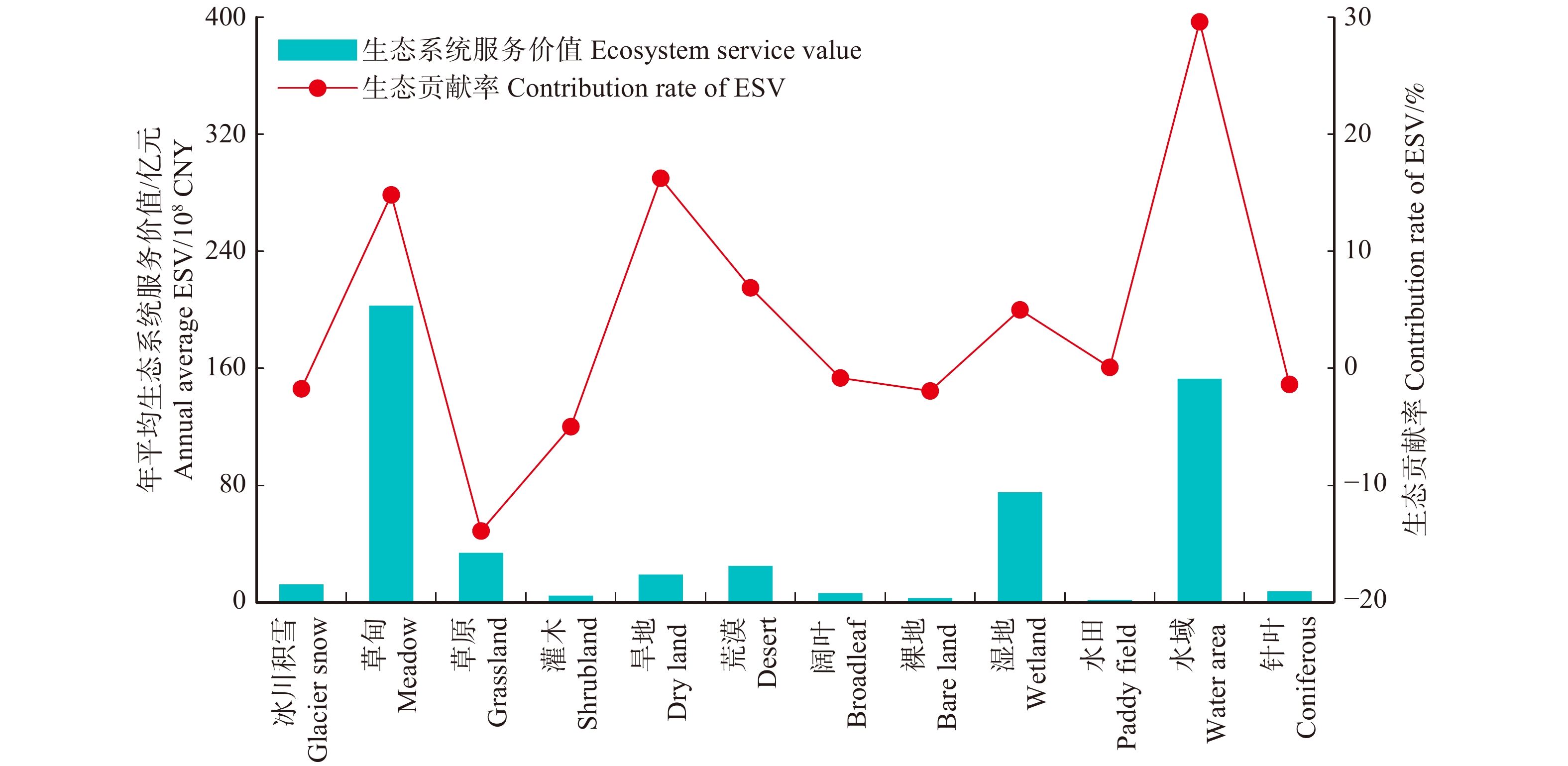
(1)生态系统服务价值结构特征分析。由博斯腾湖流域土地利用数据和表1,得到图4。结果表明,博斯腾湖流域2000、2005、2010、2015、2018年的生态系统服务价值分别为627.77、622.89、656.12、654.16、654.20亿元,总体呈波动增加趋势,增加了5.80%。从不同类型的生态系统服务价值上看,草甸价值量最大,平均占比31.44%;其次是水域和湿地,占比为23.71%和11.67%。不同地类变化量对总服务价值变化的贡献程度不同,水域、水田、湿地、荒漠、旱地、草甸的生态贡献率为正,是导致ESV增益的地类;草原、灌木、阔叶、裸地、针叶、冰川积雪的生态贡献率为负,是导致ESV减损的地类。其中水域、旱地和草甸正向生态贡献率较大,分别为29.60%、16.24%和14.82%,草原的负向生态贡献率最大,为−13.89%。因此,水域、旱地、草甸和草原是2000—2018年博斯腾湖流域生态系统服务价值变化的主要贡献因子和敏感因子。
![]() 图 4 2000—2018年博斯腾湖流域生态系统服务价值与生态贡献率Figure 4. Value contribution rate of ESV and ESV in Bosten Lake Watershed from 2000 to 2018
图 4 2000—2018年博斯腾湖流域生态系统服务价值与生态贡献率Figure 4. Value contribution rate of ESV and ESV in Bosten Lake Watershed from 2000 to 2018(2)生态系统服务价值流向特征。基于土地利用转移矩阵得到2000—2018年博斯腾湖流域ESV损益流向表(表3)。结果表明,使得博斯腾湖流域ESV增值的地类转换主要有裸地转草甸、草原转草甸和草甸转水域,分别使ESV增高了32.49、21.30和12.95亿元;导致博斯腾湖流域ESV减损的地类转换主要有草甸转草原、草甸转荒漠和草原转荒漠,分别使ESV减少了22.79、12.50和8.71亿元。主要由于草甸、草原和湿地转向水域的ESV增益,荒漠转向旱地的ESV增益,草原和裸地转向草甸的ESV增益,使得水域、旱地和草甸成为博斯腾湖流域生态系统服务价值变化的正向贡献因子。草原作为ESV变化的负向贡献因子,主要由于草甸转向草原的ESV减损导致。
表 3 2000—2018年博斯腾湖流域生态系统服务价值损益流向 108 元Table 3. Flow direction of EVS in the Bosten Lake Watershed from 2000 to 2018108 CNY 项目
Item冰川积雪
Glacier
snow草甸
Meadow草原
Grassland灌木
Shrubland旱地
Dry
land荒漠
Desert建设用地
Construction
land阔叶
Broadleaf裸地
Bare
land湿地
Wetland水域
Water
area针叶
Coniferous冰川积雪
Glacier snow0.00 0.03 0.02 7.43 0.00 0.00 草甸 Meadow −0.01 21.30 −0.19 0.42 4.71 0.16 −0.47 32.49 −4.74 −4.93 −2.53 草原 Grassland 0.00 −22.79 −1.27 0.06 4.62 0.01 −0.56 2.28 −6.04 −2.72 −0.20 灌木 Shrubland 0.31 0.65 0.05 0.62 0.00 −0.12 0.52 −0.44 −0.01 旱地 Dry land −3.43 −0.77 −1.14 4.54 0.37 −2.15 0.77 −0.72 −2.59 −0.04 荒漠 Desert −0.04 −12.50 −8.71 −2.11 −0.28 0.01 −0.83 5.00 −3.47 −5.23 −0.13 建设用地
Construction land−4.39 −6.36 −3.77 −0.34 −0.03 −1.41 0.00 −0.26 −0.60 −1.44 −0.40 阔叶 Broadleaf −0.15 −0.10 −0.11 −0.82 −0.22 −0.49 0.00 −0.02 −0.46 裸地 Bare land 0.21 0.91 0.05 1.89 1.21 0.15 0.40 −0.01 −0.01 0.00 湿地 Wetland 11.99 3.34 0.09 1.25 2.42 0.03 0.01 0.48 −4.42 水田 Paddy field −0.01 0.00 0.00 0.01 0.00 0.03 −0.02 −0.16 水域 Water area 0.02 12.95 5.95 0.93 2.45 5.38 0.39 0.56 2.41 6.97 0.81 针叶 Coniferous 1.39 1.67 0.00 0.36 −0.01 0.56 3.4 生态系统服务价值空间演变趋势
为了对博斯腾湖流域ESV空间分布进行充分表达,并保证最小可塑性单元内信息的完整性以及凸显博斯腾湖流域ESV空间差异性,本文构建300 m × 300 m的网格,计算出每个网格的ESV后,对数据进行栅格转换得到ESV栅格数据集。自然断点法基于数据的自然分组,在数值差异较大处设置边界,对相似值恰当分组,使得各数组差异最大化[40]。
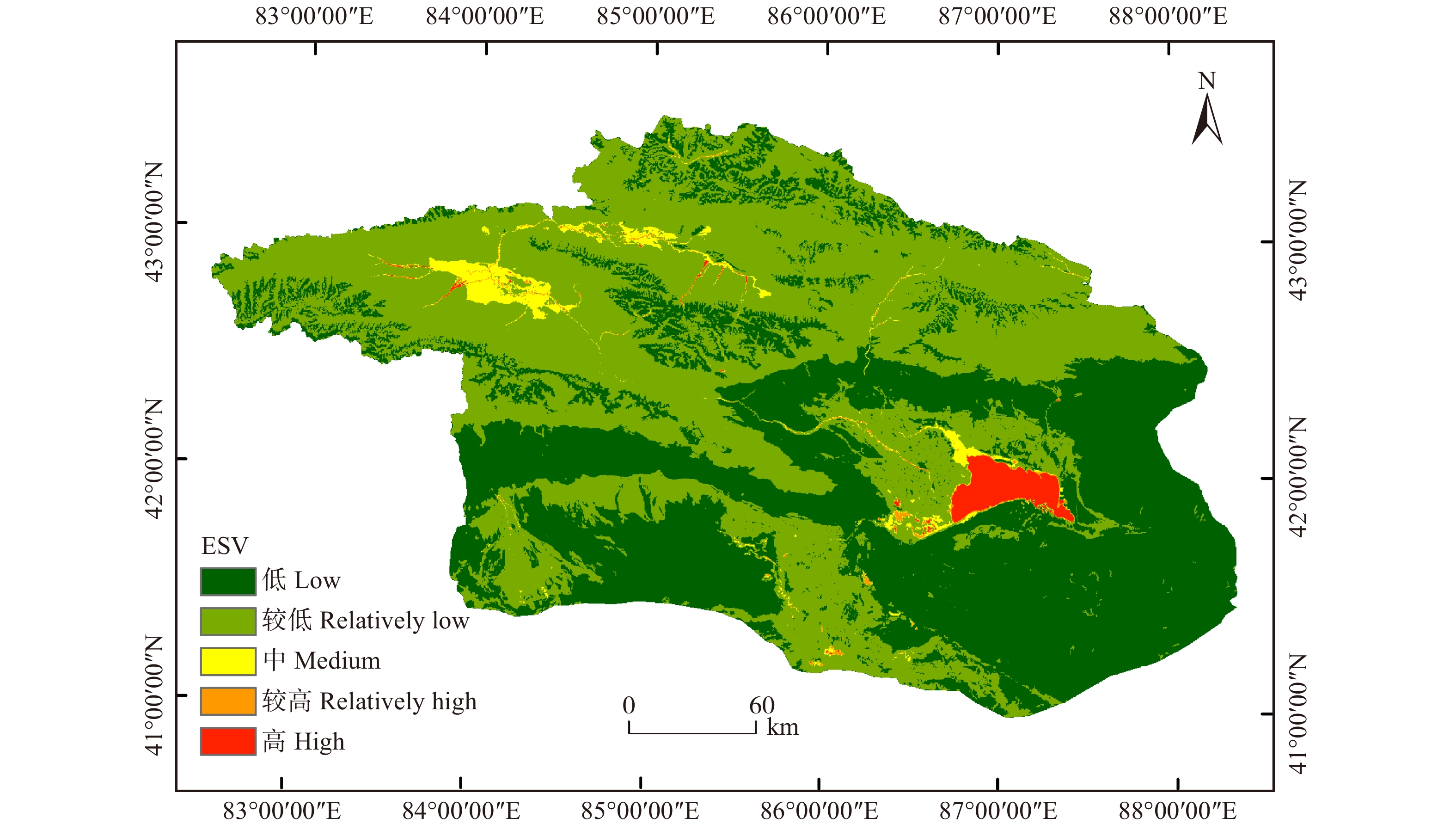
为刻画博斯腾湖流域ESV空间分布格局,计算5期ESV每个栅格的平均值,并采用自然断点法将ESV划分为5个等级,得到博斯腾湖流域生态系统服务价值空间分布(图5)。从图5可以看出,博斯腾湖流域ESV呈西北高、东南低,高值(博斯腾湖)点缀在低值区的空间分布格局。海拔较高的流域北部和西北部为ESV较低值区(主要地类为草甸、草原和冰川积雪),其中镶嵌着ESV中值区(主要地类为湿地和水域)和ESV低值区(主要地类为裸地)。流域东南部ESV高值区和较高值区主要分布于博斯腾湖及滨湖湿地、开都河主干河道。流域南部人类活动较强的地区ESV呈较低值(主要地类是旱地)。
![]() 图 5 博斯腾湖流域生态系统服务价值总体空间分布Figure 5. Overall spatial distribution of ESV in Bosten Lake Watershed
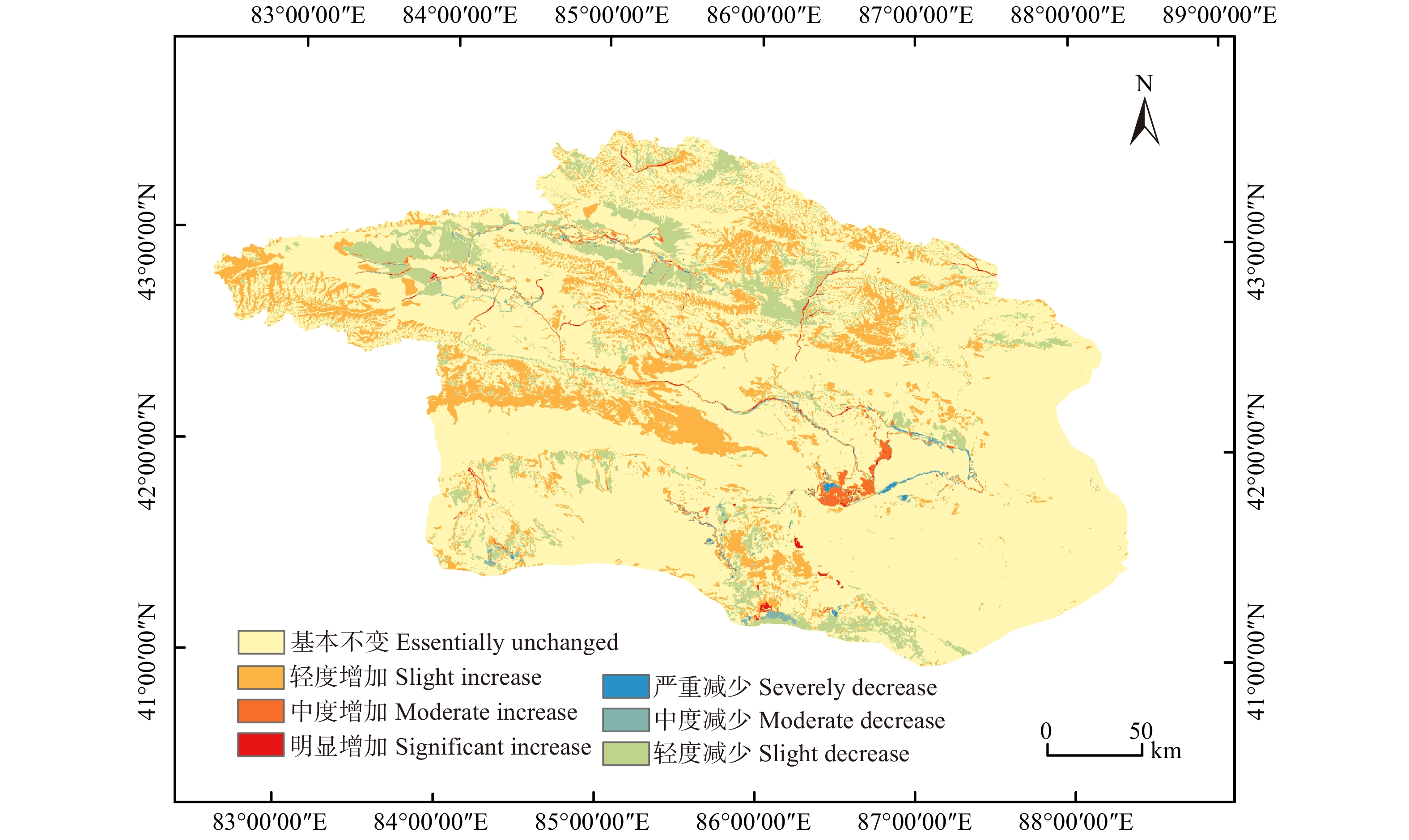
图 5 博斯腾湖流域生态系统服务价值总体空间分布Figure 5. Overall spatial distribution of ESV in Bosten Lake Watershed以ESV栅格数据集为基础,运用基于像元的一元线性回归方法对博斯腾湖流域2000—2018年ESV时空变化趋势进行分析。根据博斯腾湖变化等级图(图6),和采用自然断点法划分的趋势变化率7个等级(图7),流域北部广袤的自然生态系统的ESV多呈轻度增加趋势,主要原因是部分裸地转为草甸和冰川积雪或是草原转为草甸;少部分的草原退化使得ESV呈轻度减小趋势。流域南部生态系统受人类活动影响较大,绿洲区轨迹等级和ESV变化趋势呈环状分布。以库尔勒市为例,轨迹等级同ESV变化趋势相对应,从城市至绿洲外缘依次为:中等变化型(ESV轻度减少)—渐变型(ESV轻度增加)—中等变化型(ESV轻度减少)。城市中心由于城市化占用旱地、水域等生态用地导致ESV减少,中层由于农业发展、旱地园林扩大使得ESV有轻度增加趋势,绿洲边缘存在的过渡放牧、草原退化、荒漠化致使ESV轻度减少。
![]() 图 6 2000—2018年博斯腾湖流域变化等级图Figure 6. Map of change levels in the Bosten Lake Watershed from 2000 to 2018
图 6 2000—2018年博斯腾湖流域变化等级图Figure 6. Map of change levels in the Bosten Lake Watershed from 2000 to 2018![]() 图 7 2000—2018年博斯腾湖流域生态系统服务价值趋势分析Figure 7. Trend analysis of ESV in Bosten Lake Watershed from 2000 to 2018
图 7 2000—2018年博斯腾湖流域生态系统服务价值趋势分析Figure 7. Trend analysis of ESV in Bosten Lake Watershed from 2000 to 2018博斯腾湖、小湖湿地及周围的ESV变化趋势较为剧烈,同时存在明显增加或明显减少趋势,明显增加趋势分布于博斯腾湖周围,主要得益于滨湖荒漠、草甸向湿地的转化和滨湖湿地的保护;在库尔勒市也偶有分布,是由人工开发的水库和湿地造成的;明显减少趋势与水情要素、开发利用导致的地类频繁置换有关。
4. 结论与讨论
4.1 讨 论
基于单位服务功能价格和基于单位面积价值当量因子是目前主要的两种生态系统服务价值核算方法。本文采用优化的中国陆地生态系统服务价值当量因子,开展土地利用变化对博斯腾湖流域生态系统服务价值的影响研究,并根据流域生态系统特点对土地利用类型进行细分,这一定程度上提高了评价结果的准确性,该模型中的生态系统服务价值量采用2000—2018各期的平均值,加强了生态系统服务价值时间序列上的可比性。但本文仍存在生态系统服务价值系数修正方法单一、静态等缺点,在接下来的研究中,将会进一步改进修正方法,并结合建设用地生态系统服务价值,选用更高解译精度的土地利用数据来进一步提高评价精度。
正如本文引言中所述,目前大多数研究多采用热点分析等传统空间统计方法描述ESV时空变化,忽略了生态系统服务价值总体空间变化描述。人类活动的空间差异性使得生态系统服务价值具有差异性,为了更好地描述这一过程,本文采用土地利用时间序列追踪分析与趋势分析相结合的方式,揭示了绿洲城市的土地利用冲突现状及ESV时空变化,将来可在城市扩张的土地利用冲突及规划、城市发展的生态效益等方面研究发挥作用。由于本研究基于流域尺度,对绿洲区人工生态系统服务价值变化研究不够,今后的研究中可加强绿洲尺度的生态系统服务价值驱动力、土地利用对生态系统服务价值影响的空间定量研究。
根据本文的研究结果,气候暖湿化使得流域北部自然生态系统好转,整体ESV增加,但绿洲区ESV存在不同程度的减少趋势,故可以通过相关举措来管理和调整绿洲土地利用:(1)干旱区的生态环境异常脆弱,水资源维系着农业生产、经济社会发展,是生态价值系数最高的地类。本研究发现仅占流域总面积的3.61%的湿地和水域,主导着流域生态系统服务价值的变化,应加强对二者的保护。(2)由于生态输水的需要,孔雀河下游建立的水库使得草原面积减少,同时加剧耕地的开发、湿地缩减,政府管理部门应严格控制耕地规模,对草原、湿地进行保护。
4.2 结 论
本文以博斯腾湖流域为例,基于2000、2005、2010年、2015和2018年5期的土地利用数据,运用土地利用时间序列追踪分析、趋势分析等方法,探究博斯腾湖流域土地利用变化轨迹和生态系统服务价值的时空演变规律,揭示了土地利用变化及其对博斯腾湖流域ESV的影响及其空间分布格局,得出以下结论:
(1)博斯腾湖流域主要的土地利用类型是荒漠、草甸和裸地,在研究时段内水田、荒漠、草甸、湿地、水域、旱地、建设用地面积增加;草原、灌木、裸地、针叶、阔叶、冰川积雪面积减少。研究期内,建设用地的单一土地利用动态度较大,2005—2010年综合土地利用动态度最大。
(2)2000—2018年博斯腾湖流域未发生变化的土地利用类型面积,即稳定型占流域面积的60.43%,是最大的轨迹类型。渐变型占流域总面积的34.97%,亚稳定型占流域面积的2.54%,中等变化型、回归型和激烈变化型多分布于人类活动较强的绿洲地区。
(3)2000—2018年博斯腾湖流域ESV总体上呈现波动增长趋势,流域ESV主要由草甸、水域和湿地构成。水域、旱地、草甸和草原是流域ESV变化的主要贡献因子和敏感因子,其中水域、旱地和草甸为正向贡献因子,草原为负向贡献因子。博斯腾湖流域ESV增值的地类转换主要有裸地转草甸、草原转草甸和草甸转水域;导致博斯腾湖流域ESV减损的地类转换主要有草甸转草原、草甸转荒漠和草原转荒漠。
(4)博斯腾湖流域ESV总体空间分布呈“西北高,东南低”,高值(博斯腾湖)点缀在低值区的空间分布特征。ESV明显增加趋势的地区主要分布于博斯腾湖滨湖湿地,库尔勒地区也有分布;轻度增加趋势和轻度减少趋势在流域南部绿洲边缘以及东南部的焉耆盆地内边缘并存;流域北部大部分ESV呈轻度增加趋势,主要由于由部分裸地转为草甸和冰川积雪导致,流域北部的草甸、草原退化也使得部分地区ESV呈轻度减少趋势。
(5)博斯腾湖流域ESV变化趋势的空间差异性较为显著,流域北部对气候变化较为敏感,且受人类活动影响较小,LUCC追踪等级整体较低,ESV是轻度变化趋势;南部生态系统受人类活动影响较大,绿洲区轨迹等级和ESV变化趋势从城市至绿洲边缘呈:中等变化型(ESV轻度减少)—渐变型(ESV轻度增加)—中等变化型(ESV轻度减少)环状相间结构,博斯腾湖周围的ESV变化趋势最为剧烈。
-
![]()
图 2 2000—2018年博斯腾湖流域所有可能的LUCC变化轨迹及典型例子
Figure 2. All possible LUCC change trajectories and examples in Bosten Lake Watershed from 2000 to 2018
![]()
图 3 2000—2018年博斯腾湖流域轨迹类型
Figure 3. Trajectory type in the Bosten Lake Watershed from 2000 to 2018
![]()
图 4 2000—2018年博斯腾湖流域生态系统服务价值与生态贡献率
Figure 4. Value contribution rate of ESV and ESV in Bosten Lake Watershed from 2000 to 2018
![]()
图 5 博斯腾湖流域生态系统服务价值总体空间分布
Figure 5. Overall spatial distribution of ESV in Bosten Lake Watershed
![]()
图 6 2000—2018年博斯腾湖流域变化等级图
Figure 6. Map of change levels in the Bosten Lake Watershed from 2000 to 2018
![]()
图 7 2000—2018年博斯腾湖流域生态系统服务价值趋势分析
Figure 7. Trend analysis of ESV in Bosten Lake Watershed from 2000 to 2018
表 1 博斯腾湖流域生态系统服务价值系数表 元/(hm2·a)
Table 1 Coefficients of the ecosystem service value in Bosten Lake Watershed
CNY/(ha·year) 一级类型
First category供给服务
Provisioning service调节服务
Regulating service支持服务
Supporting service文化服务
Cultural service二级分类
Second category食物生产
Food production原料生产
Material production水资源
供给
Water
supply气体调节
Gas regulation气候调节
Climate regulation净化环境
Purify environment水文调节
Hydrological adjusting土壤保持
Soil conservation维持
养分循环
Maintaining
nutrient cycling生物
多样性
Biodiversity美学景观
Aesthetic landscapeDL 928.59 436.98 21.85 731.94 393.28 109.25 294.96 1 125.23 131.09 142.02 65.55 PF 1 485.74 98.32 −2 873.15 1 212.62 622.70 185.72 2 971.47 10.92 207.57 229.42 98.32 C 240.34 568.08 294.96 1 857.17 5 538.74 1 627.76 3 648.80 2 250.45 174.79 2 053.81 895.81 B 316.81 721.02 371.43 2 370.62 7 100.95 2 108.44 5 178.23 2 895.00 218.49 2 632.81 1 158.00 S 207.57 469.76 240.34 1 540.36 4 621.08 1 398.34 3 659.72 1 879.02 142.02 1 715.15 753.79 G 109.25 152.94 87.40 557.15 1 463.89 480.68 1 070.60 677.32 54.62 611.77 273.11 M 240.34 360.51 196.64 1 245.40 3 299.21 1 092.45 2 414.32 1 518.51 120.17 1 387.42 611.77 W 557.15 546.23 2 829.45 2 075.66 3 932.83 3 932.83 26 470.15 2 523.57 196.64 8 597.61 5 167.31 D 10.92 32.77 21.85 120.17 109.25 338.66 229.42 142.02 10.92 131.09 54.62 BL 0.00 0.00 0.00 21.85 0.00 109.25 32.77 21.85 0.00 21.85 10.92 WA 873.96 251.26 9 056.44 841.19 2 501.72 6 063.12 111 692.46 1 015.98 76.47 2 785.76 2 064.74 GS 0.00 0.00 2 359.70 196.64 589.92 174.79 7 789.19 0.00 0.00 10.92 98.32 注:GS代表冰川积雪;M代表草甸;G代表草原;S灌木;DL代表旱地;D代表荒漠;B代表阔叶;BL代表裸地;W代表湿地;PF代表水田;WA代表水域;C代表针叶。Notes: GS means glacier snow; M means meadow; G means grassland; S means shrubland; DL means dry land; D means desert; B means broadleaf; BL means bare land; W means wetland; PF means paddy field; WA means water area; C means coniferous.  下载: 导出CSV
表 2 2000—2018年博斯腾湖流域土地利用面积百分比和动态度
Table 2 Land use area percentage and dynamic degree in the Bosten Lake Watershed from 2000 to 2018
% 土地利用类型
Land use type土地面积比例
Proportional of different
land use types单一动态度
Dynamic of single
land use综合动态度
Dynamic of integrated
land use2000 2005 2010 2015 2018 2000—2018 2000—2005 2005—2010 2010—2015 2015—2018 荒漠 Desert 27.50 26.96 33.97 32.41 32.37 3.55 0.26 3.62 0.44 0.22 草甸 Meadow 23.84 23.71 24.76 24.85 24.85 0.85 裸地 Bare land 26.88 26.85 18.90 19.53 19.35 −5.59 草原 Grassland 11.01 10.89 9.00 8.88 8.87 −3.88 旱地 Dry land 4.04 4.96 6.33 7.36 7.57 15.30 湿地 Wetland 1.91 1.88 2.11 2.07 1.99 0.78 水域 Water area 1.60 1.55 1.66 1.67 1.78 2.30 冰川积雪 Glacier snow 1.28 1.19 1.31 1.23 1.17 −0.47 针叶 Coniferous 0.69 0.69 0.47 0.63 0.63 −1.75 阔叶 Broadleaf 0.65 0.52 0.45 0.40 0.40 −7.78 建设用地 Construction land 0.28 0.33 0.49 0.64 0.66 28.24 灌木 Shrubland 0.34 0.49 0.52 0.31 0.31 −1.63 水田 Paddy field 0.00 0.00 0.02 0.02 0.02 0
下载: 导出CSV
表 3 2000—2018年博斯腾湖流域生态系统服务价值损益流向 108 元
Table 3 Flow direction of EVS in the Bosten Lake Watershed from 2000 to 2018
108 CNY 项目
Item冰川积雪
Glacier
snow草甸
Meadow草原
Grassland灌木
Shrubland旱地
Dry
land荒漠
Desert建设用地
Construction
land阔叶
Broadleaf裸地
Bare
land湿地
Wetland水域
Water
area针叶
Coniferous冰川积雪
Glacier snow0.00 0.03 0.02 7.43 0.00 0.00 草甸 Meadow −0.01 21.30 −0.19 0.42 4.71 0.16 −0.47 32.49 −4.74 −4.93 −2.53 草原 Grassland 0.00 −22.79 −1.27 0.06 4.62 0.01 −0.56 2.28 −6.04 −2.72 −0.20 灌木 Shrubland 0.31 0.65 0.05 0.62 0.00 −0.12 0.52 −0.44 −0.01 旱地 Dry land −3.43 −0.77 −1.14 4.54 0.37 −2.15 0.77 −0.72 −2.59 −0.04 荒漠 Desert −0.04 −12.50 −8.71 −2.11 −0.28 0.01 −0.83 5.00 −3.47 −5.23 −0.13 建设用地
Construction land−4.39 −6.36 −3.77 −0.34 −0.03 −1.41 0.00 −0.26 −0.60 −1.44 −0.40 阔叶 Broadleaf −0.15 −0.10 −0.11 −0.82 −0.22 −0.49 0.00 −0.02 −0.46 裸地 Bare land 0.21 0.91 0.05 1.89 1.21 0.15 0.40 −0.01 −0.01 0.00 湿地 Wetland 11.99 3.34 0.09 1.25 2.42 0.03 0.01 0.48 −4.42 水田 Paddy field −0.01 0.00 0.00 0.01 0.00 0.03 −0.02 −0.16 水域 Water area 0.02 12.95 5.95 0.93 2.45 5.38 0.39 0.56 2.41 6.97 0.81 针叶 Coniferous 1.39 1.67 0.00 0.36 −0.01 0.56
下载: 导出CSV
-
[1] 郑华, 欧阳志云, 赵同谦, 等. 人类活动对生态系统服务功能的影响[J]. 自然资源学报, 2003, 18(1):118−126. Zheng H, Ouyang Z Y, Zhao T Q, et al. The impact of human activities on ecosystem services[J]. Journal of Natural Resources, 2003, 18(1): 118−126.
[2] Assesment M E. Ecosystems and human well-being: synthesis[J]. Physics Teacher, 2005, 34(9): 534−534.
[3] 雷军成, 王莎, 汪金梅, 等. 土地利用变化对寻乌县生态系统服务价值的影响[J]. 生态学报, 2019, 39(9):3089−3099. Lei J C, Wang S, Wang J M, et al. Effects of land use change on ecosystem services value of Xunwu County[J]. Acta Ecologica Sinica, 2019, 39(9): 3089−3099.
[4] 严恩萍, 林辉, 王广兴, 等. 1990—2011年三峡库区生态系统服务价值演变及驱动力[J]. 生态学报, 2014, 34(20):5962−5973. Yan E P, Lin H, Wang G X, et al. Analysis of evolution and driving force of ecosystem service values in the Three Gorges Reservoir region during 1990—2011[J]. Acta Ecologica Sinica, 2014, 34(20): 5962−5973.
[5] 傅伯杰, 张立伟. 土地利用变化与生态系统服务: 概念、方法与进展[J]. 地理科学进展, 2014, 33(4):441−446. doi: 10.11820/dlkxjz.2014.04.001 Fu B J, Zhang L W. Land use change and ecosystem services: concepts, methods and progress[J]. Progress in Geography, 2014, 33(4): 441−446. doi: 10.11820/dlkxjz.2014.04.001
[6] 谢高地, 肖玉, 鲁春霞. 生态系统服务研究: 进展、局限和基本范式[J]. 植物生态学报, 2006, 30(2):191−199. doi: 10.3321/j.issn:1005-264X.2006.02.001 Xie G D, Xiao Y, Lu C X. Study on ecosystem services: progress, limitation and basic paradigm[J]. Chinese Journal of Plant Ecology, 2006, 30(2): 191−199. doi: 10.3321/j.issn:1005-264X.2006.02.001
[7] 夏鑫鑫, 朱磊, 杨爱民, 等. 基于山地−绿洲−荒漠系统的生态系统服务正负价值测算: 以新疆玛纳斯河流域为例[J]. 生态学报, 2020, 40(12):3921−3934. Xia X X, Zhu L, Yang A M, et al. Evaluate the positive and negative value of ecosystem services based on Mountain-Desert-Oasis system (MODS): a case study of Manas River Basin in Xinjiang[J]. Acta Ecologica Sinica, 2020, 40(12): 3921−3934.
[8] Costanza R, d’Arge R, Groot R D, et al. The value of the world’s ecosystem services and natural capital[J]. Nature, 1997, 387(15): 253−260.
[9] Daily G C. Nature’s services: societal dependence on natural ecosystems[M]. Washiongton: Island Press, 1997.
[10] 谢高地, 鲁春霞, 冷允法, 等. 青藏高原生态资产的价值评估[J]. 自然资源学报, 2003, 18(2):189−196. doi: 10.3321/j.issn:1000-3037.2003.02.010 Xie G D, Lu C X, Leng Y F, et al. Ecological assets valuation of the Tibetan Plateau[J]. Journal of Natural Resources, 2003, 18(2): 189−196. doi: 10.3321/j.issn:1000-3037.2003.02.010
[11] 朱青, 周自翔, 刘婷, 等. 黄土高原植被恢复与生态系统土壤保持服务价值增益研究:以延河流域为例[J]. 生态学报, 2021, 41(7):2557−2570. Zhu Q, Zhou Z X, Liu T, et al. Vegetation restoration and ecosystem soil conservation service value increment in Yanhe Watershed, Loess Plateau[J]. Acta Ecologica Sinica, 2021, 41(7): 2557−2570.
[12] Ma X, Zhu J, Zhang H, et al. Trade-offs and synergies in ecosystem service values of inland lake wetlands in central asia under land use/cover change: a case study on Ebinur Lake, China[J/OL]. Global Ecology and Conservation, 2020, 24: e01253 [2021−01−05]. https://doi.org/10.1016/j.gecco.2020.e01253.
[13] 王波, 杨太保. 1980—2018年银川市生态系统服务价值评价及驱动力分析[J]. 干旱区地理, 2021, 44(2):552−564. Wang B, Yang T B. Value evaluation and driving force analysis of ecosystem services in Yinchuan City from 1980 to 2018[J]. Arid Land Geography, 2021, 44(2): 552−564.
[14] Liu S, Yang M, Mou Y, et al. Effect of urbanization on ecosystem service values in the Beijing-Tianjin-Hebei urban agglomeration of China from 2000 to 2014[J/OL]. Sustainability, 2020, 12(24): 10233 [2020−12−08]. https://doi.org/10.3390/su122410233.
[15] Tan Z, Guan Q, Lin J, et al. The response and simulation of ecosystem services value to land use/land cover in an oasis, Northwest China[J/OL]. Ecological Indicators, 2020, 118: 106711 [2020−07−22]. https://doi.org/10.1016/j.ecolind.2020.106711.
[16] 雷金睿, 陈宗铸, 陈小花, 等. 1980—2018年海南岛土地利用与生态系统服务价值时空变化[J]. 生态学报, 2020, 40(14):4760−4773. Lei J R, Chen Z Z, Chen X H, et al. Spatio-temporal changes of land use and ecosystem services value in Hainan Island from 1980 to 2018[J]. Acta Ecologica Sinica, 2020, 40(14): 4760−4773.
[17] Zhou F C, Han X Z, Tang S H, et al. An improved model for evaluating ecosystem service values using land use/cover and vegetation parameters[J]. Journal of Meteorological Research, 2021, 35(1): 148−156. doi: 10.1007/s13351-021-9199-x
[18] 潘洪义, 张琴, 李加安, 等. 基于动态当量的彝汉交错深度贫困区生态系统服务价值时空演变研究[J]. 生态学报, 2020, 40(22):8218−8229. Pan H Y, Zhang Q, Li J A, et al. Spatial and temporal evolution of ecosystem service value based on dynamic equivalent in Yi-Han severely impoverished areas[J]. Acta Ecologica Sinica, 2020, 40(22): 8218−8229.
[19] 黄木易, 岳文泽, 方斌, 等. 1970—2015年大别山区生态服务价值尺度响应特征及地理探测机制[J]. 地理学报, 2019, 74(9):1904−1920. doi: 10.11821/dlxb201909015 Huang M Y, Yue W Z, Fang B, et al. Scale response characteristics and geographic exploration mechanism of spatial differentiation of ecosystem service values in Dabie Mountain area, central China from 1970 to 2015[J]. Acta Geographica Sinica, 2019, 74(9): 1904−1920. doi: 10.11821/dlxb201909015
[20] 邵明, 董宇翔, 林辰松. 基于GWR模型的成渝城市群生态系统服务时空演变及驱动因素研究[J]. 北京林业大学学报, 2020, 42(11):118−129. Shao M, Dong Y X, Lin C S. Spatial-temporal evolution and driving factors of ecosystem services in Chengdu-Chongqing urban agglomeration based on GWR model[J]. Journal of Beijing Forestry University, 2020, 42(11): 118−129.
[21] Zhou Y K, Zhang X Y, Yu H, et al. Land use-driven changes in ecosystem service values and simulation of future scenarios: A case study of the Qinghai–Tibet Plateau[J/OL]. Sustainability, 2021, 13: 4079 [2021−05−13]. https://doi.org/10.3390/su13074079.
[22] 郭椿阳, 高尚, 周伯燕, 等. 基于格网的伏牛山区土地利用变化对生态服务价值影响研究[J]. 生态学报, 2019, 39(10):3482−3493. Guo C Y, Gao S, Zhou B Y, et al. Effects of land use change on ecosystem service value in Funiu Mountain based upon a grid square[J]. Acta Ecologica Sinica, 2019, 39(10): 3482−3493.
[23] 程静, 黄越. 宁夏回族自治区生态系统服务价值时空演变及其驱动力[J]. 水土保持研究, 2021, 28(2):382−389. Cheng J, Huang Y. Spatiotemporal evolution of ecosystem services value and its driving forces in Ningxia Hui Autonomous Region[J]. Research of Soil and Water Conservation, 2021, 28(2): 382−389.
[24] Hoonchong Y. Impacts of land change on ecosystem service values and environmental sustainability in North Korea (Democratic People’s Republic of Korea) through the 2030s[J]. Journal of the Korean Geographical Society, 2020, 55(2): 97−121.
[25] 乔斌, 祝存兄, 曹晓云, 等. 格网尺度下青海玛多县土地利用及生态系统服务价值空间自相关分析[J]. 应用生态学报, 2020, 31(5):1660−1672. Qiao B, Zhu C X, Cao X Y, et al. Spatial autocorrelation analysis of land use and ecosystem service value in Maduo County, Qinghai Province, China at the grid scale[J]. Journal of Applied Ecology, 2020, 31(5): 1660−1672.
[26] Mertens B, Lambin E F. Land-cover-change trajectories in Southern Cameroon[J]. Annals of the Association of American Geographers, 2015, 90(3): 467−494.
[27] 黄方, 张学敏. 白山市土地利用/覆被变化轨迹分析与趋势预测[J]. 应用基础与工程科学学报, 2015, 23(3):439−451. Huang F, Zhang X M. Land use/cover change trajectories and tendency forecast in Baishan City[J]. Journal of Basic Science and Engineering, 2015, 23(3): 439−451.
[28] 张学敏. 基于GIS的吉林省白山市土地利用/覆被变化分析与模拟[D]. 长春: 东北师范大学, 2012. Zhang X M. Analysis and simulation of land use/cover change in Baishan City of Jilin Province, China based on GIS[D]. Changchun: Northeast Normal University, 2012.
[29] 李晓蕾, 魏建新, 徐丽萍, 等. 基于CLUE-S模型的博斯腾湖流域土地利用变化情景模拟[J]. 石河子大学学报(自然科学版), 2019, 37(3):345−352. Li X L, Wei J X, Xu L P, et al. Scenario simulation of land use change in Boston Lake Basin based on CLUE-S mode[J]. Journal of Shihezi University (Natural Science), 2019, 37(3): 345−352.
[30] 谢高地, 张彩霞, 张昌顺, 等. 中国生态系统服务的价值[J]. 资源科学, 2015, 37(9):1740−1746. Xie G D, Zhang C X, Zhang C S, et al. The value of ecosystem services in China[J]. Resources Science, 2015, 37(9): 1740−1746.
[31] Zhou Q, Li B, Kurban A. Trajectory analysis of land cover change in arid environment of China[J]. International Journal of Remote Sensing, 2008, 29(4): 1093−1107. doi: 10.1080/01431160701355256
[32] 约麦尔·麦麦提, 玉素甫江·如素力, 拜合提尼沙·阿不都克日木, 等. 近22年叶尔羌河-喀什噶尔河三角洲绿洲土地利用结构变化及其驱因分析[J]. 草业科学, 2018, 35(2):244−255. doi: 10.11829/j.issn.1001-0629.2017-0291 Aizezitiyuemaier Maimaiti, Yusufujiang Rusuli, Baihetinisha Abudukamu, et al. Analysis of the land use structure change and driving factors in the delta oasis of the Yarkand-Kashgar River over the last 22 years[J]. Pratacultural Science, 2018, 35(2): 244−255. doi: 10.11829/j.issn.1001-0629.2017-0291
[33] 朱会义, 李秀彬. 关于区域土地利用变化指数模型方法的讨论[J]. 地理学报, 2003, 58(5):643−650. doi: 10.3321/j.issn:0375-5444.2003.05.001 Zhu H Y, Li X B. Discussion on regional land use change index model[J]. Journal of Geochemistry, 2003, 58(5): 643−650. doi: 10.3321/j.issn:0375-5444.2003.05.001
[34] 李晓东, 李相坤, 姜琦刚. 基于空间变异理论的地表覆被时空变化监测方法[J]. 草业科学, 2015, 32(6):877−885. doi: 10.11829/j.issn.1001-0629.2014-0448 Li X D, Li X K, Jiang Q G. The monitoring method of the surface vegetation based on the spatial variation analysis[J]. Pratacultural Science, 2015, 32(6): 877−885. doi: 10.11829/j.issn.1001-0629.2014-0448
[35] 谢高地, 张彩霞, 张雷明, 等. 基于单位面积价值当量因子的生态系统服务价值化方法改进[J]. 自然资源学报, 2015, 30(8):1243−1254. doi: 10.11849/zrzyxb.2015.08.001 Xie G D, Zhang C X, Zhang L M, et al. Improvement of the evaluation method for ecosystem service value based on per unit area[J]. Journal of Natural Resources, 2015, 30(8): 1243−1254. doi: 10.11849/zrzyxb.2015.08.001
[36] 谢高地, 肖玉, 甄霖, 等. 我国粮食生产的生态服务价值研究[J]. 中国生态农业学报, 2005, 13(3):10−13. Xie G D, Xiao Y, Zhen L, et al. Study on ecosystem services value of food production in China[J]. Chinese Journal of Ecological Agriculture, 2005, 13(3): 10−13.
[37] 阿迪来·乌甫, 玉素甫江·如素力, 热伊莱·卡得尔, 等. 基于MODIS数据的新疆地表蒸散量时空分布及变化趋势分析[J]. 地理研究, 2017, 36(7):1245−1256. Adilai Wufu, Yusufujiang Rusuli, Reyilai Kadeer, et al. Spatio-temporal distribution and evolution trend of evapotranspiration in Xinjiang based on MOD16 data[J]. Geographic Research, 2017, 36(7): 1245−1256.
[38] 封建民, 郭玲霞, 李晓华. 汉中市土地利用时空变化及其对生态系统服务价值的影响[J]. 水土保持研究, 2020, 27(1):275−282. Feng J M, Guo L X, Li X H. Temporal and spatial variations of land use and their influences on ecosystem service function values in Hanzhong City[J]. Water and Soil Conservation Research, 2020, 27(1): 275−282.
[39] 买尔哈巴·买买提汗, 玉素甫江·如素力, 安尼瓦尔·阿布都热依木, 等. 近26 a博斯腾湖芦苇湿地的动态监测及其驱动因素[J]. 干旱区研究, 2016, 33(4):797−804. Maierhaba Maimaitihan, Yusufujiang Rusuli, Anniwaer Abudureyimu, et al. Dynamic variation of phragmites australis wetland in the Bosten Lake Basin and its driving factors in recent 26 years[J]. Arid Zone Research, 2016, 33(4): 797−804.
[40] 段亚明, 刘勇, 刘秀华, 等. 基于POI大数据的重庆主城区多中心识别[J]. 自然资源学报, 2018, 33(5):788−800. doi: 10.11849/zrzyxb.20170945 Duan Y M, Liu Y, Liu X H, et al. Identification of polycentric urban structure of central chongqing using points of interest big data[J]. Journal of Natural Resources, 2018, 33(5): 788−800. doi: 10.11849/zrzyxb.20170945
-
期刊类型引用(0)
其他类型引用(1)


计量
- 文章访问数: 1569
- HTML全文浏览量: 577
- PDF下载量: 93
- 被引次数: 1
