
Pathway and method of forest health assessment using remote sensing technology
-
摘要: 近年来,随着气候变化和人类活动的加剧,全球森林面积持续减少、质量下降,生态环境事件频发,森林健康的问题受到前所未有的关注,已经成为生态文明战略的重要组成部分。我国森林资源持续增长,但同时也面临一些问题,如:造林结构单一、林分质量不高、生态稳定性弱等,如何系统准确评价其森林健康状况仍然是当前难点。相对于传统地面调查方法,遥感技术具有实时获取、重复监测以及多时空尺度等优势,并且随着高分遥感和人工智能等技术的飞速发展,大幅提高了解决森林健康评价难题的能力。为系统评估新型遥感技术应用于评价森林健康的潜力,本文在文献分析基础上,指出了现有路径和方法,具体包括:(1)通过文献计量学方法分析并明确了森林健康评价的4大核心内容(活力、组织结构、抵抗力和恢复力)和4大关键问题(树种分类、林木活力、林业有害生物、干旱胁迫)。(2)从不同尺度(单木−林分−生态系统−景观)、不同平台(近地面遥感−航空遥感−卫星遥感)和不同传感器(包括RGB相机、多/高光谱相机、激光雷达、热红外相机、微波雷达和叶绿素荧光扫描仪)3个角度,系统梳理现有遥感技术的优缺点。(3)围绕4个关键问题,阐述近年来应用遥感技术评价森林健康的路径和方法。进一步,本文指出了包括多数据源融合分析、森林健康监测网络与近地面遥感、森林健康大数据应用在内的挑战与机遇,以期为我国森林资源智慧管理提供参考。Abstract: In recent years, with the aggravation of climate change and human activities, the global forest area continues to reduce, forest quality keeps declining, and the ecological and environmental events occur frequently. Thus, forest health issues have received unprecedented attention, and have become an important part of the ecological civilization strategy. China’s forest resources continue to grow, but it also faces some problems, such as single afforestation structure, low stand quality and weak ecological stability. How to evaluate forest health systematically and accurately is still a difficult problem. Compared with the traditional ground survey methods, remote sensing technology has the advantages of macroscopic, timeliness and economic efficiency. With the rapid development of high-resolution remote sensing and artificial intelligence technology, it is possible to overcome the problem of forest health assessment. In order to systematically evaluate the potential of new remote sensing technology, this paper points out the existing paths and methods on the basis of literature analysis, including: (1) through bibliometric analysis, four core contents of forest health assessment (vitality, organizational structure, resistance and resilience) and four key issues (tree species classification, forest vitality, forest pests, drought threat) were identified. (2) Systematically interpreting the advantages and disadvantages of existing remote sensing technologies from three angles, namely, different scales (single tree stand ecosystem landscape), different platforms (near ground remote sensing, aerial remote sensing satellite remote sensing) and different sensors (including RGB cameras, multi/hyperspectral cameras, lidar, thermal infrared cameras, microwave radars and chlorophyll fluorescence scanners). (3) Focusing on four key issues, this paper expounds the application path and method of remote sensing technology to evaluate forest health in recent years. Furthermore, this paper points out the challenges and opportunities, including multi-source fusion analysis, forest health monitoring network and near ground remote sensing, forest health big data application, in order to provide reference for the intelligent management of forest resources in China.
-
Keywords:
- forest health /
- remote sensing /
- sensor /
- VOR system /
- forestry pest
-
-
![]()
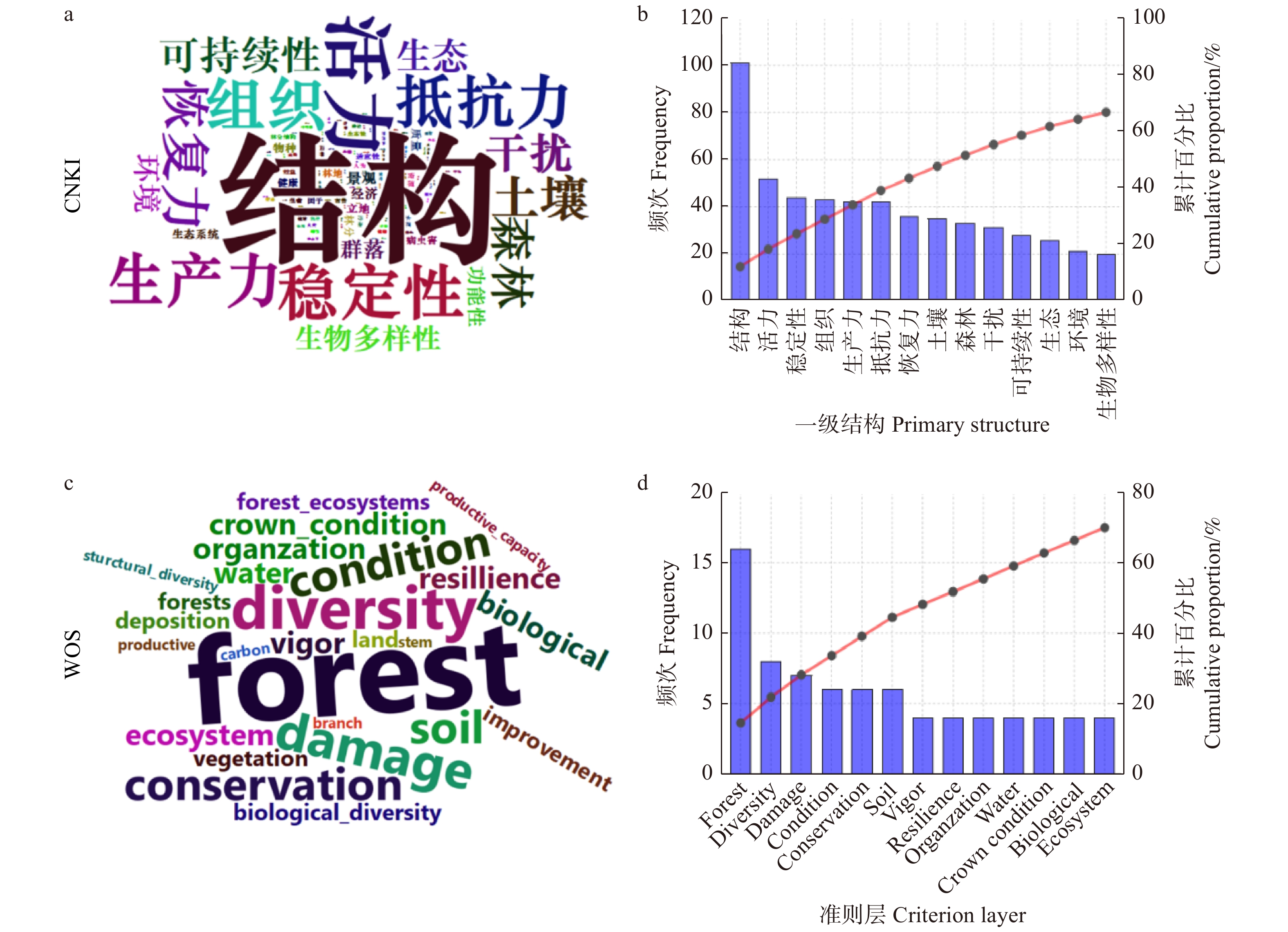
图 1 森林健康评价指标体系一级结构、准则层的词云图和词频分析
Figure 1. Word cloud and frequency analysis of primary structure and criterion layer of forest health assessment indicator system
![]()
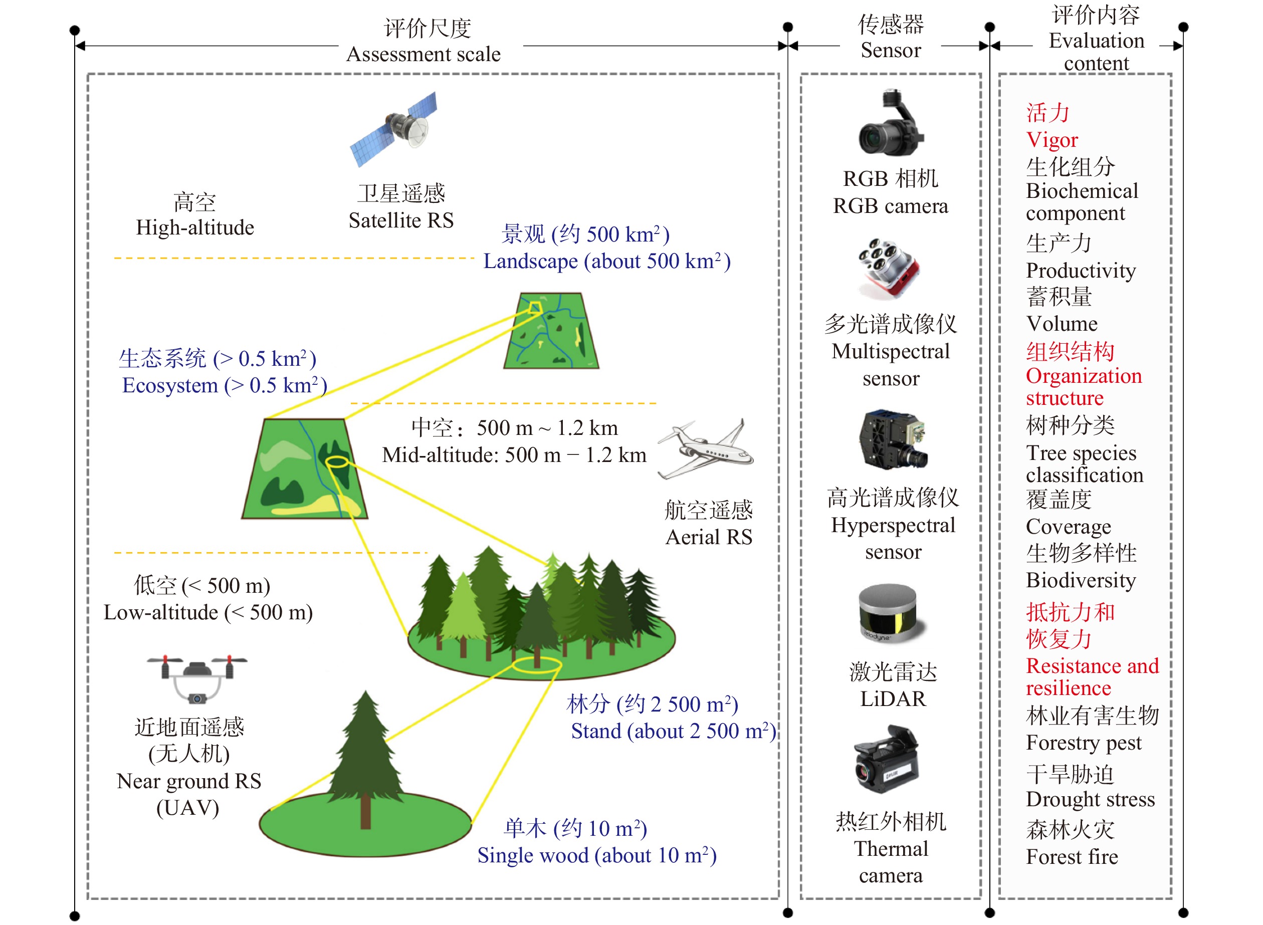
图 2 多尺度、多平台遥感技术评价森林健康概念图
Figure 2. Concept map of multi-scale, multi-platform remote sensing assessment of forest health
表 1 不同传感器在森林健康评价中的技术优势和主要评价内容
Table 1 Advantages and application of different sensors in forest health assessment
传感器
Sensor技术优势
Technical advantage主要不足
Main shortcomings特征参量
Feature parameter评价内容
Assessment contentRGB高分相机
RGB high-resolution camera低成本、高空间分辨率
Low cost, high spatial resolution成像质量受光照条件影响大、光谱信息有限
Image quality is influenced by illumination conditions, limited spectral informationRGB图像、纹理
RGB image, texture普适性好,一般作为遥感底图或摄影测量数据
Widely used as RS base map or photogrammetric data多光谱成像仪
Multispectral sensor几个波段的反射率
Reflectance of several bands异物同谱、同物异谱问题使数据解译困难
Difficult data interpretation due to synonyms spectrum多光谱图像、多通道反射率
Multispectral image, multi-channel reflectance树种分类、主要生化组分、物候、胁迫
Tree species classification, main biochemical components, phenology, stress高光谱成像仪
Hyperspectral sensor上百个窄波段的反射率
Reflectance of hundreds of narrow bands观测条件严格、数据量大、分析难度大
Strict observation condition and difficult data analysis图谱立方体
Hyperspectral cube树种分类、多种生化组分、光合作用、物候、早期胁迫
Tree species classification, photosynthesis, various biochemical components, phenology, early stress热红外相机
Thermal camera全天候、穿透性、精细温差
All weather, penetrating, fine temperature difference温度变化易受周围环境影响
Temperature variation is easily affected by the surrounding environment方向亮度温度、热红外图像
Directional brightness temperature, thermal infrared image森林火灾、森林干旱、光合作用、早期胁迫
Forest fire, drought, photosynthesis, early stress激光雷达
LiDAR穿透性、精细的地形和森林三维信息
Penetrating, fine terrain and 3D forest information缺少光谱、纹理信息
Lack of spectral and texture information点云廓线、波形
Point cloud profile, waveform地形、位置、生物量、蓄积量、冠层结构、叶面积指数
Topography, location, biomass, volume, canopy structure, LAI微波雷达
Microwave radar全天候,一定穿透性,可达地下
All weather, limited penetrating, reaching underground斑点噪声大、受地形影响
严重
Speckle noise and seriously affected by terrain后向散射、干涉系数、极化雷达图像
Backscattering, interference coefficient, polarimetric radar image地形、生物量、蓄积量、水分、土壤
Topography, biomass, volume, moisture, soil叶绿素荧光扫描仪
Chlorophyll fluorescence scanner获取日光诱导的叶绿素信息
Capturing chlorophyll information induced by sunlight受大气影响大、时空连续性有限
Affected by atmosphere, limited space-time continuity荧光参数、光化学效率
Fluorescence parameters, photochemical efficiency初级生产力、碳循环、物候、早期胁迫
Primary productivity, carbon cycle, phenology, early stress 下载: 导出CSV
-
[1] 许勤. 绿色就是固碳造林等于减排:记国家林业局造林司司长魏殿生[J]. 林业经济, 2003(2):10−11. Xu Q. Green means carbon sequestration and afforestation equals emission reduction: Wei Diansheng, director of afforestation department of State Forestry Administration[J]. Forestry Economy, 2003(2): 10−11.
[2] 高均凯. 深入研究森林健康积极探索中国森林健康之路[J]. 北京林业管理干部学院学报, 2005(1):22−25. Gao J K. Research on the implementation of forest health strategy in China[J]. State Academy of Forestry Administration Journal, 2005(1): 22−25.
[3] 王云霖. 我国人工林发展研究[J]. 林业资源管理, 2019(1):6−11. Wang Y L. Research on plantation development in China[J]. Forestry Resource Management, 2019(1): 6−11.
[4] 胡爽, 徐誉远, 王本洋. 我国森林健康评价方法综述[J]. 林业与环境科学, 2017, 33(1):90−96. doi: 10.3969/j.issn.1006-4427.2017.01.017 Hu S, Xu Y Y, Wang B Y. Review of forest health monitoring and assessment in China[J]. Forestry and Environmental Science, 2017, 33(1): 90−96. doi: 10.3969/j.issn.1006-4427.2017.01.017
[5] 王秋燕, 陈鹏飞, 李学东, 等. 森林健康评价方法综述[J]. 南京林业大学学报(自然科学版), 2018, 42(2):177−183. Wang Q Y, Chen P F, Li X D, et al. Review of forest health assessment methods[J]. Journal of Nanjing Forestry University (Natural Sciences Edition), 2018, 42(2): 177−183.
[6] Pause M, Schweitzer C, Rosenthal M, et al. In situ/remote sensing integration to assess forest health: a review[J/OL]. Remote Sensing, 2016, 8(6): 471 [2021−01−12]. https://doi.org/10.3390/rs8060471.
[7] 金瑞华, 张宏名, 林培. 浅谈生物灾害遥感监测[J]. 遥感信息, 1991(3):35−37. Jin R H, Zhang H M, Lin P. Discussion on remote sensing monitoring of biological disasters[J]. Remote Sensing Information, 1991(3): 35−37.
[8] 高广磊, 信忠保, 丁国栋, 等. 基于遥感技术的森林健康研究综述[J]. 生态学报, 2013, 33(6):1675−1689. doi: 10.5846/stxb201112011838 Gao G L, Xin Z B, Ding G D, et al. Forest health studies based on remote sensing: a review[J]. Acta Ecologica Sinica, 2013, 33(6): 1675−1689. doi: 10.5846/stxb201112011838
[9] 何兴元, 任春颖, 陈琳, 等. 森林生态系统遥感监测技术研究进展[J]. 地理科学, 2018, 38(7):997−1011. He X Y, Ren C Y, Chen L, et al. The progress of forest ecosystems monitoring with remote sensing techniques [J]. Scientia Geographica Sinica, 2018, 38(7): 997−1011.
[10] 王彦辉, 肖文发, 张星耀. 森林健康监测与评价的国内外现状和发展趋势[J]. 林业科学, 2007, 43(7):84−91. Wang Y H, Xiao W F, Zhang X Y. Current status and development tendency of forest health monitoring and evaluation[J]. Scientia Silvae Sinicae, 2007, 43(7): 84−91.
[11] 马有国, 杜学惠. 森林健康评价的遥感技术研究[J]. 森林工程, 2019, 35(2):37−44. Ma Y G, Du X H. Remote sensing technology for forest health assessment[J]. Forest Engineering, 2019, 35(2): 37−44.
[12] Lausch A, Borg E, Bumberger J, et al. Understanding forest health with remote sensing, part III: requirements for a scalable multi-source forest health monitoring network based on data science approaches[J/OL]. Remote Sensing, 2018, 10(7): 1120 [2021−01−15]. https://doi.org/10.3390/rs10071120.
[13] Lausch A, Stefan E, Douglas K, et al. Understanding forest health with remote sensing (I): a review of spectral traits, processes and remote sensing characteristics[J/OL]. Remote Sensing, 2016, 8(10): 1029 [2020−12−19]. https://doi.org/10.3390/rs8121029.
[14] Lausch A, Stefan E, Douglas K, et al. Understanding forest health with remote sensing (II): a review of approaches and data models[J/OL]. Remote Sensing, 2017, 9(2): 129 [2020−12−28]. https://doi.org/10.3390/rs10071120.
[15] 高均凯. 森林健康基本理论及评价方法研究[D]. 北京: 北京林业大学, 2007. Gao J K. Basic theory and evaluation method of forest health[D]. Beijing: Beijing Forestry University, 2007.
[16] Costanza R. Toward an operational definition of ecosystem health [M]//Costanza R, Norton B G, Haskell B D, eds. Ecosystem health: new goals for environmental management. Washington D C: Island Press, 1992: 239−256.
[17] Senf C, Seidl R, Hostert P. Remote sensing of forest insect disturbances: current state and future directions[J]. International Journal of Applied Earth Observation & Geoinformation, 2017, 60: 49−60.
[18] Felbermeier B, Hahn A, Schneider T. Study on user requirements for remote sensing applications in forestry[C/OL]. ISPRS TC VII Symposium – 100 Years ISPRS. 2010 [2021−02−13]. https://www.researchgate.net/profile/Thomas-Schneider-10/publication/266412426_STUDY_ON_USER_REQUIREMENTS_FOR_REMOTE_SENSING_APPLICATIONS_IN_FORESTRY/links/55b6566a08ae092e9655d92c/STUDY-ON-USER-REQUIREMENTS-FOR-REMOTE-SENSING-APPLICATIONS-IN-FORESTRY.pdf.
[19] Fabian E, Hooman L, Krzysztof S, et al. Review of studies on tree species classification from remotely sensed data[J]. Remote Sensing of Environment, 2016, 186: 64−97. doi: 10.1016/j.rse.2016.08.013
[20] 孔嘉鑫, 张昭臣, 张健. 基于多源遥感数据的植物物种分类与识别: 研究进展与展望[J]. 生物多样性, 2019, 27(7):796−812. doi: 10.17520/biods.2019197 Kong J X, Zhang Z C, Zhang J. Classification and identification of plant species based on multi-source remote sensing data: research progress and prospect[J]. Biodiversity Science, 2019, 27(7): 796−812. doi: 10.17520/biods.2019197
[21] Ferreira M, Zortea M, Zanotta D, et al. Mapping tree species in tropical seasonal semi-deciduous forests with hyperspectral and multispectral data[J]. Remote Sensing of Environment, 2016, 179: 66−78. doi: 10.1016/j.rse.2016.03.021
[22] Asner G. Biophysical and biochemical sources of variability in canopy reflectance[J]. Remote Sensing of Environment, 1998, 64(3): 234−253. doi: 10.1016/S0034-4257(98)00014-5
[23] Clark M, Roberts D, Clark B. Hyperspectral discrimination of tropical rain forest tree species at leaf to crown scales[J]. Remote Sensing of Environment, 2005, 96(3−4): 375−398. doi: 10.1016/j.rse.2005.03.009
[24] Leckie D, Tinis S, Nelson T, et al. Issues in species classification of trees in old growth conifer stands[J]. Canadian Journal of Remote Sensing, 2005, 31(2): 175−190. doi: 10.5589/m05-004
[25] 马鸿伟, 刘海, 姚顺彬, 等. 基于林业遥感的树种分类应用分析与展望[J]. 林业资源管理, 2020(3):118−121. Ma H W, Liu H, Yao S B, et al. Application and prospect of tree species classification based on forest remote sensing[J]. Forestry Resource Management, 2020(3): 118−121.
[26] Cao J, Leng W, Liu K, et al. Object-based mangrove species classification using unmanned aerial vehicle hyperspectral images and digital surface models[J/OL]. Remote Sensing, 2018, 10(2): 89 [2021−01−16]. https://doi.org/10.3390/rs10010089.
[27] Franklin S, Hall R, Moskal L, et al. Incorporating texture into classification of forest species composition from airborne multispectral images[J]. International Journal of Remote Sensing, 2000, 21(1): 61−79. doi: 10.1080/014311600210993
[28] Sayn-Wittgenstein L. Recognition of tree species on aerial photographs[J/OL]. Forest Management Institute Information Report, 1978, FMR-X-118 [2021−01−19]. https://cfs.nrcan.gc.ca/pubwarehouse/pdfs/29443.pdf.
[29] Mallinis G, Koutsias N, Tsakiri-Strati M, et al. Object-based classification using Quickbird imagery for delineating forest vegetation polygons in a Mediterranean test site[J]. ISPRS Journal of Photogrammetry & Remote Sensing, 2008, 63(2): 237−250.
[30] Chuine I, Beaubien E. Phenology is a major determinant of tree species range[J]. Ecology Letters, 2001, 4: 500−510. doi: 10.1046/j.1461-0248.2001.00261.x
[31] Gärtner P, Förster M, Kleinschmit B. The benefit of synthetically generated RapidEye and Landsat 8 data fusion time series for riparian forest disturbance monitoring[J]. Remote Sensing of Environment, 2016, 177: 237−247. doi: 10.1016/j.rse.2016.01.028
[32] Signoroni A, Savardi M, Baronio A, et al. Deep learning meets hyperspectral image analysis: a multidisciplinary review[J/OL]. Journal of Imaging, 2019, 5(5): 52 [2021−02−13]. https://doi.org/10.3390/jimaging5050052.
[33] 徐岩, 张聪伶, 降瑞娇, 等. 无人机高光谱影像与冠层树种多样性监测[J]. 生物多样性, 2021, 29(5):647−660. doi: 10.17520/biods.2021013 Xu Y, Zhang C L, Xiang R J, et al. UAV-based hyperspectral images and monitoring of canopy tree diversity[J]. Biodiversity Science, 2021, 29(5): 647−660. doi: 10.17520/biods.2021013
[34] Asner G, Knapp D, Kennedy-Bowdoin T, et al. Invasive species detection in Hawaiian rainforests using airborne imaging spectroscopy and LiDAR[J]. Remote Sensing of Environment, 2008, 112(5): 1942−1955. doi: 10.1016/j.rse.2007.11.016
[35] Riaño D, Chuvieco E, Condés S. Generation of crown bulk density for Pinus sylvestris L. from lidar[J]. Remote Sensing of Environment, 2004, 92: 345−352. doi: 10.1016/j.rse.2003.12.014
[36] Coops N, Hilker T, Wulder M, et al. Estimating canopy structure of douglas-fir forest stands from discrete-return LiDAR[J]. Trees, 2007, 21: 295−310. doi: 10.1007/s00468-006-0119-6
[37] Suratno A, Seielstad C, Queen L. Tree species identification in mixed coniferous forest using airborne laser scanning[J]. ISPRS Journal of Photogrammetry & Remote Sensing, 2009, 64(6): 683−693.
[38] Korpela I, Orka H, Hyyppae J, et al. Range and AGC normalization in airborne discrete-return LiDAR intensity data for forest canopies[J]. ISPRS Journal of Photogrammetry & Remote Sensing, 2010, 65(4): 369−379.
[39] Kim S, McGaughey R, Andersen H, et al. Tree species differentiation using intensity data derived from leaf-on and leaf-off airborne laser scanner data[J]. Remote Sensing of Environment, 2009, 113(8): 1575−1586. doi: 10.1016/j.rse.2009.03.017
[40] 黄华国. 激光雷达技术在林业科学研究中的进展分析[J]. 北京林业大学学报, 2013, 35(3):134−143. Huang H G. Progress analysis of LiDAR research on forestry science studies[J]. Journal of Beijing Forestry University, 2013, 35(3): 134−143.
[41] 郭庆华, 刘瑾, 李玉美, 等. 生物多样性近地面遥感监测: 应用现状与前景展望[J]. 生物多样性, 2016, 24(11):1249−1266. doi: 10.17520/biods.2016059 Guo Q H, Liu J, Li Y M, et al. A near-surface remote sensing platform for biodiversity monitoring: perspectives and prospects[J]. Biodiversity Science, 2016, 24(11): 1249−1266. doi: 10.17520/biods.2016059
[42] Michez A, Piegay H, Lisein J, et al. Classification of riparian forest species and health condition using multi-temporal and hyperspatial imagery from unmanned aerial system[J/OL]. Environmental Monitoring & Assessment, 2016, 188: 146 [2021−01−19]. https://link.springer.com/article/10.1007/s10661-015-4996-2.
[43] Lu D, Weng Q. A survey of image classification methods and techniques for improving classification performance[J]. International Journal of Remote Sensing, 2007, 28: 823−870. doi: 10.1080/01431160600746456
[44] Cheng J, Bo Y, Zhu Y, et al. A novel method for assessing the segmentation quality of high-spatial resolution remote-sensing images[J]. International Journal of Remote Sensing, 2014, 35: 3816−3839. doi: 10.1080/01431161.2014.919678
[45] Aguirre-Gutiérrez J, Seijmonsbergen A, Duivenvoorden J. Optimizing land cover classification accuracy for change detection, a combined pixel-based and object-based approach in a mountainous area in Mexico[J]. Applied Geography, 2012, 34: 29−37. doi: 10.1016/j.apgeog.2011.10.010
[46] Larsen M, Eriksson M, Descombes X, et al. Comparison of six individual tree crown detection algorithms evaluated under varying forest conditions[J]. International Journal of Remote Sensing, 2011, 32(20): 5827−5852. doi: 10.1080/01431161.2010.507790
[47] 肖风劲, 欧阳华, 孙江华, 等. 森林生态系统健康评价指标与方法[J]. 林业资源管理, 2004(1):27−30. doi: 10.3969/j.issn.1002-6622.2004.01.007 Xiao F J, Ouyang H, Sun J H, et al. Forest ecosystem health assessment indicators and methods[J]. Forest Resources Management, 2004(1): 27−30. doi: 10.3969/j.issn.1002-6622.2004.01.007
[48] Schlemmer M, Gitelson A, Schepers J, et al. Remote estimation of nitrogen and chlorophyll contents in maize at leaf and canopy levels[J]. International Journal of Applied Earth Observation and Geoinformation, 2017, 25: 47−54.
[49] Inoue Y, Sakaiya E, Zhu Y, et al. Diagnostic mapping of canopy nitrogen content in rice based on hyperspectral measurements[J]. Remote Sensing of Environment, 2012, 126: 210−221. doi: 10.1016/j.rse.2012.08.026
[50] Xie Q, Huang W, Liang D, et al. Leaf area index estimation using vegetation indices derived from airborne hyperspectral images in winter wheat[J]. IEEE Journal of Selected Topics in Applied Earth Observations and Remote Sensing, 2014, 7(8): 3586−3594. doi: 10.1109/JSTARS.2014.2342291
[51] 黄华国. 林业定量遥感研究进展和展望[J]. 北京林业大学学报, 2019, 41(12):1−14. doi: 10.12171/j.1000-1522.20190326 Huang H G. Progress and prospect of quantitative remote sensing in forestry[J]. Journal of Beijing Forestry University, 2019, 41(12): 1−14. doi: 10.12171/j.1000-1522.20190326
[52] 黄华国. 三维遥感机理模型RAPID原理及其应用[J]. 遥感技术与应用, 2019, 34(5):901−913. Huang H G. Principles and applications of the three-dimensional remote sensing mechanism model RAPID[J]. Remote Sensing Technology and Application, 2019, 34(5): 901−913.
[53] Paul J. Remote sensing of foliar chemistry[J]. Remote Sensing of Environment, 1989, 30(3): 271−278. doi: 10.1016/0034-4257(89)90069-2
[54] Daughtry C, Walthall C, Kim M, et al. Estimating corn leaf chlorophyll concentration from leaf and canopy reflectance[J]. Remote Sensing of Environment, 2000, 74: 229−239. doi: 10.1016/S0034-4257(00)00113-9
[55] Datt B. Remote sensing of chlorophyll a, chlorophyll b, chlorophyll a+b, and total carotenoid content in eucalyptus leaves[J]. Remote Sensing of Environment, 1998, 66: 111−121. doi: 10.1016/S0034-4257(98)00046-7
[56] Asner G, Martin R. Airborne spectranomics: mapping canopy chemical and taxonomic diversity in tropical forests[J]. Frontiers in Ecology and the Environment, 2009, 7: 269−276. doi: 10.1890/070152
[57] Ustin S, Gitelson A, Jacquemoud S, et al. Retrieval of foliar information about plant pigment systems from high resolution spectroscopy[J]. Remote Sensing of Environment, 2009, 113: 67−77. doi: 10.1016/j.rse.2008.10.019
[58] Malenovský Z, Homolová L, Zurita-Milla R, et al. Retrieval of spruce leaf chlorophyll content from airborne image data using continuum removal and radiative transfer[J]. Remote Sensing of Environment, 2013, 131: 85−102. doi: 10.1016/j.rse.2012.12.015
[59] McManus K, Asner G, Martin R, et al. Phylogenetic structure of foliar spectral traits in tropical forest canopies[J/OL]. Remote Sensing, 2016, 8(3): 196 [2021−01−18]. https://doi.org/10.3390/rs8030196.
[60] Serrano L, Penuelas J, Ustin S. Remote sensing of nitrogen and lignin in Mediterranean vegetation from AVIRIS data: decomposing biochemical from structural signals[J]. Remote Sensing of Environment, 2002, 81: 355−364. doi: 10.1016/S0034-4257(02)00011-1
[61] Thenkabail P, Lyon J, Huete A. Hyperspectral remote sensing of vegetation[M]. Boca Raton: CRC Press, 2016.
[62] Assal T, Anderson P, Sibold J. Spatial and temporal trends of drought effects in a heterogeneous semi-arid forest ecosystem[J]. Forest Ecology and Management, 2016, 365: 137−151. doi: 10.1016/j.foreco.2016.01.017
[63] Klosterman S, Hufkens K, Gray J, et al. Gray J, et al. Evaluating remote sensing of deciduous forest phenology at multiple spatial scales using PhenoCam imagery[J]. Biogeosciences, 2014, 11: 4305−4320. doi: 10.5194/bg-11-4305-2014
[64] van Wittenberghe S, Verrelst J, Rivera J, et al. Gaussian processes retrieval of leaf parameters from a multi-species reflectance, absorbance and fluorescence dataset[J]. Journal of Photochemistry and Photobiology B-Biology, 2014, 134: 37−48. doi: 10.1016/j.jphotobiol.2014.03.010
[65] Asner G, Knapp D, Anderson C, et al. Large-scale climatic and geophysical controls on the leaf economics spectrum[J]. PNAS, 2016, 113: 4043−4051. doi: 10.1073/pnas.1604863113
[66] Schlerf M, Atzberger C, Hill J, et al. Retrieval of chlorophyll and nitrogen in Norway spruce (Picea abies, L. Karst.) using imaging spectroscopy[J]. International Journal of Applied Earth Observation and Geoinformation, 2010, 12: 17−26. doi: 10.1016/j.jag.2009.08.006
[67] 章钊颖, 王松寒, 邱博, 等. 日光诱导叶绿素荧光遥感反演及碳循环应用进展[J]. 遥感学报, 2019, 23(1):37−52. Zhang Z Y, Wang S H, Qiu B, et al. Remote sensing retrieval of sunlight induced chlorophyll fluorescence and application of carbon cycle[J]. Acta Remote Sensing, 2019, 23(1): 37−52.
[68] Potter C, Randerson J, Field C, et al. Terrestrial ecosystem production-A process model-based on global satellite and surface data[J]. Global Biogeochemical Cycles, 1993, 7: 811−841. doi: 10.1029/93GB02725
[69] Li X, Xiao J, He B, et al. Chlorophyll fluorescence observed by OCO-2 is strongly related to gross primary productivity estimated from flux towers in temperate forests[J]. Remote Sensing of Environment, 2018, 204: 659−671. doi: 10.1016/j.rse.2017.09.034
[70] 郭庆华, 胡天宇, 马勤, 等. 新一代遥感技术助力生态系统生态学研究[J]. 植物生态学报, 2020, 44(4):418−435. doi: 10.17521/cjpe.2019.0206 Guo Q H, Hu T Y, Ma Q, et al. Advances for the new remote sensing technology in ecosystem ecology research[J]. Chinese Journal of Plant Ecology, 2020, 44(4): 418−435. doi: 10.17521/cjpe.2019.0206
[71] Frydenvang J, Maarschalkerweerd M, Carstensen A, et al. Sensitive detection of phosphorus deficiency in plants using chlorophyll a fluorescence[J]. Plant Physiology, 2015, 169: 353−361. doi: 10.1104/pp.15.00823
[72] Sun Y, Frankenberg C, Wood J, et al. OCO-2 advances photosynthesis observation from space via solar-induced chlorophyll fluorescence[J]. Science, 2017, 358: 747.
[73] Wolanin A, Rozanov V, Dinter T, et al. Global retrieval of marine and terrestrial chlorophyll fluorescence at its red peak using hyperspectral top of atmosphere radiance measurements: feasibility study and first results[J]. Remote Sensing of Environment, 2015, 166: 243−261. doi: 10.1016/j.rse.2015.05.018
[74] Köhler P, Guanter L, Joiner J. A linear method for the retrieval of sun-induced chlorophyll fluorescence from GOME-2 and SCIAMACHY data[J]. Atmospheric Measurement Techniques, 2015, 8(6): 2589−2608. doi: 10.5194/amt-8-2589-2015
[75] Mcroberts R, Næsset E, Gobakken T. Inference for lidar-assisted estimation of forest growing stock volume[J]. Remote Sensing of Environment, 2013, 128: 268−275. doi: 10.1016/j.rse.2012.10.007
[76] Cartus O, Kellndorfer J, Rombach M. Mapping canopy height and growing stock volume using airborne lidar, ALOS PALSAR and Landsat ETM+[J]. Remote Sensing, 2012, 4: 3320−3345. doi: 10.3390/rs4113320
[77] 李增元, 赵磊, 李堃, 等. 合成孔径雷达森林资源监测技术研究综述[J]. 南京信息工程大学学报, 2020, 12(2):150−158. Li Z Y, Zhao L, Li K, et al. A survey of developments on forest resources monitoring technology of synthetic aperture radar[J]. Journal of Nanjing University of Information Technology, 2020, 12(2): 150−158.
[78] 李亚东, 冯仲科, 明海军, 等. 无人机航测技术在森林蓄积量估测中的应用[J]. 测绘通报, 2017(4):63−66. Li Y D, Feng Z K, Ming H J, et al. Application of UAV aerial survey technology in forest volume estimation[J]. Surveying and Mapping Bulletin, 2017(4): 63−66.
[79] 黄麟, 张晓丽, 石韧. 森林病虫害遥感监测技术研究的现状与问题[J]. 遥感信息, 2006(2):71−75. doi: 10.3969/j.issn.1000-3177.2006.02.020 Huang L, Zhang X L, Shi R. Current status and problems in monitoring forest damage caused by diseases and insects based on remote sensing[J]. Remote Sensing Information, 2006(2): 71−75. doi: 10.3969/j.issn.1000-3177.2006.02.020
[80] 王蕾, 骆有庆, 张晓丽, 等. 遥感技术在森林病虫害监测中的应用研究进展[J]. 世界林业研究, 2008, 21(5):37−43. Wang L, Luo Y Q, Zhang X L, et al. Application development of remote sensing technology in the assessment of forest pest disaster[J]. World Forestry Research, 2008, 21(5): 37−43.
[81] Stone C, Mohammed C. Application of remote sensing technologies for assessing planted forests damaged by insect pests and fungal pathogens: a review[J]. Current Forestry Reports, 2017, 3(2): 1−18.
[82] Hall R J, van der Sanden J J, Freeburn J T, et al. Remote sensing of natural disturbance caused by insect defoliation and dieback: a review[R]. Edmonton: Natural Resources Canada, 2016.
[83] Coops N, Johnson M, Wulder M, et al. Assessment of QuickBird high spatial resolution imagery to detect red attack damage due to mountain pine beetle infestation[J]. Remote Sensing of Environment, 2006, 103(1): 67−80. doi: 10.1016/j.rse.2006.03.012
[84] Bright B, Hudak A, McGaughey R, et al. Predicting live and dead tree basal area of bark beetle affected forests from discrete-return lidar[J]. Canadian Journal of Remote Sensing, 2013, 39: 99−111. doi: 10.5589/m13-027
[85] Carter G, Knapp A. Leaf optical properties in higher plants: linking spectral characteristics to stress and chlorophyll concentration[J]. American Journal of Botany, 2001, 88: 677−684. doi: 10.2307/2657068
[86] Ustin S, Roberts D, Gamon J, et al. Using imaging spectroscopy to study ecosystem processes and properties[J]. Bioscience, 2004, 54: 523−534. doi: 10.1641/0006-3568(2004)054[0523:UISTSE]2.0.CO;2
[87] Niemann K, Quinn G, Stephen R, et al. Hyperspectral remote sensing of mountain pine beetle with an emphasis on previsual assessment[J]. Canadian Journal of Remote Sensing, 2015, 41(3): 191−202. doi: 10.1080/07038992.2015.1065707
[88] Hernández-Clemente R, Hornero A, Mottus M, et al. Early diagnosis of vegetation health from high-resolution hyperspectral and thermal imagery: lessons learned from empirical relationships and radiative transfer modelling[J]. Current Forestry Reports, 2019, 5: 169−183. doi: 10.1007/s40725-019-00096-1
[89] Abdullah H, Darvishzadeh R, Skidmore A, et al. European spruce bark beetle (Ips typographus L.) green attack affects foliar reflectance and biochemical properties[J]. International Journal of Applied Earth Observation & Geoinformation, 2018, 64: 199−209.
[90] Peterson D, Aber J, Matson P, et al. Remote sensing of forest canopy and leaf biochemical contents[J]. Remote Sensing of Environment, 1988, 24: 85−108. doi: 10.1016/0034-4257(88)90007-7
[91] 徐华潮, 骆有庆, 张廷廷, 等. 松材线虫自然侵染后松树不同感病阶段针叶光谱特征变化[J]. 光谱学与光谱分析, 2011, 31(5):1352−1356. doi: 10.3964/j.issn.1000-0593(2011)05-1352-05 Xu H C, Luo Y Q, Zhang T T, et al. Changes of reflectance spectra of pine needles in different stage after being infected by pine wood nematode[J]. Spectroscopy and Spectral Analysis, 2011, 31(5): 1352−1356. doi: 10.3964/j.issn.1000-0593(2011)05-1352-05
[92] Liu Y J, Zhan Z Y, Ren L L, et al. Hyperspectral evidence of early-stage pine shoot beetle attack in Yunnan pine[J]. Forest Ecology and Management, 2021, 497: 1118−1127.
[93] Yu L, Zhan Z, Ren L, et al. Evaluating the potential of worldview-3 data to classify different shoot damage ratios of Pinus yunnanensis[J/OL]. Forests, 2020, 11: 417 [2021−01−14]. https://doi.org/10.3390/f11040417.
[94] Zhan Z, Yu L, Ren L, et al. Combining GF-2 and Sentinel-2 images to detect tree mortality caused by red turpentine beetle during the early outbreak stage in north China[J]. Forests, 2020, 11(2): 172. doi: 10.3390/f11020172
[95] Senf C, Pflugmacher D, Hostert P, et al. Using Landsat time series for characterizing forest disturbance dynamics in the coupled human and natural systems of Central Europe[J]. ISPRS Journal of Photogrammetry and Remote Sensing, 2017, 130: 453−463. doi: 10.1016/j.isprsjprs.2017.07.004
[96] Yu L, Huang J, Zong S, et al. Detecting shoot beetle damage on Yunnan pine using Landsat time-series data[J/OL]. Forests, 2018, 9: 39 [2021−01−19]. https://doi.org/10.3390/f9010039.
[97] Gašparović M, Jurjević L. Gimbal influence on the stability of exterior orientation parameters of UAV acquired images[J/OL]. Sensors, 2017, 17(2): 401 [2021−01−15]. https://doi.org/10.3390/s17020401.
[98] Näsi R, Honkavaara E, Paivi L, et al. Using UAV-based photogrammetry and hyperspectral imaging for mapping bark beetle damage at tree-level[J]. Remote Sensing, 2015, 7: 15467−15493. doi: 10.3390/rs71115467
[99] Yu R, Luo Y Q, Zhou Q, et al. A machine learning algorithm to detect pine wilt disease using UAV-based hyperspectral imagery and LiDAR data at the tree level[J/OL]. International Journal of Applied Earth Observation and Geoinformation, 2021, 101(1): 102363 [2021−01−21]. https://doi.org/10.1016/j.jag.2021.102363.
[100] 鲁芮伶, 杜莹, 晏黎明, 等. 森林树木死亡的判定方法及其应用综述[J]. 科学通报, 2019, 64(23):2395−2409. Lu R L, Du Y, Yan L M, et al. A review of forest tree death determination methods and their application[J]. Scientific Bulletin, 2019, 64(23): 2395−2409.
[101] Parker J, Patton R. Effects of drought and defoliation on some metabolites in roots of black oak seedlings[J]. Canadian Journal of Forest Research, 1975, 5: 457−463. doi: 10.1139/x75-063
[102] Hartmann H, Ziegler W, Trumbore S. Lethal drought leads to reduction in nonstructural carbohydrates in Norway spruce tree roots but not in the canopy[J]. Functional Ecology, 2013, 27: 413−427. doi: 10.1111/1365-2435.12046
[103] Adams H, Zeppel M, Anderegg W, et al. A multi-species synthesis of physiological mechanisms in drought-induced tree mortality[J]. Nature Ecology and Evolution, 2017, 1: 1285−1291. doi: 10.1038/s41559-017-0248-x
[104] 周国逸, 李琳, 吴安驰. 气候变暖下干旱对森林生态系统的影响[J]. 南京信息工程大学学报(自然科学版), 2020, 12(1):81−88. Zhou G Y, Li L, Wu A C. Effect of drought on forest ecosystem under warming climate[J]. Journal of Nanjing University of Information Technology (Nature Science Edition), 2020, 12(1): 81−88.
[105] Bowman W. The relationship between leaf water status, gas exchange, and spectral reflectance in cotton leaves[J]. Remote Sensing of Environment, 1989, 30(3): 249−255. doi: 10.1016/0034-4257(89)90066-7
[106] 郝增超, 侯爱中, 张璇, 等. 干旱监测与预报研究进展与展望[J]. 水利水电技术, 2020, 51(11):30−40. Hao Z C, Hou A Z, Zhang X, et al. Study progresses and prospects of drought monitoring and prediction[J]. Water Conservancy and Hydropower Technology, 2020, 51(11): 30−40.
[107] 周磊, 武建军, 张洁. 以遥感为基础的干旱监测方法研究进展[J]. 地理科学, 2015, 35(5):630−636. Zhou L, Wu J J, Zhang J. Remote sensing-based drought monitoring approach and research progress[J]. Scientia Geographica Sinica, 2015, 35(5): 630−636.
[108] Li X, Xiao J, He B. Higher absorbed solar radiation partly offset the negative effects of water stress on the photosynthesis of Amazon forests during the 2015 drought[J/OL]. Environmental Research Letters, 2018, 13(4): 044005 [2020−10−12]. https://iopscience.iop.org/article/10.1088/1748-9326/aab0b1.
[109] Reddy A, Chaitanya K, Vivekanandan M. Drought-induced responses of photosynthesis and antioxidant metabolism in higher plants[J]. Journal of Plant Physiology, 2004, 161(11): 1189−1202. doi: 10.1016/j.jplph.2004.01.013
[110] Lambers H, Chapin F, Chapin F, et al. Plant water relations in plant physiological ecology[M]. New York: Springer, 2008: 163−217.
[111] Breshears D, Cobb N, Rich P, et al. Regional vegetation die-off in response to global change-type drought[J]. PNAS, 2005, 102(42): 15144−15148. doi: 10.1073/pnas.0505734102
[112] Running S, Nemani R, Heinsch F, et al. A continuous satellite-derived measure of global terrestrial primary production[J]. Bioscience, 2004, 54(6): 547−560. doi: 10.1641/0006-3568(2004)054[0547:ACSMOG]2.0.CO;2
[113] Huang C, Asner G, Barger N, et al. Regional aboveground live carbon losses due to drought-induced tree dieback in Pinyon-Juniper ecosystems[J]. Remote Sensing of Environment, 2010, 114(7): 1471−1479. doi: 10.1016/j.rse.2010.02.003
[114] Clifford M, Cobb N, Buenemann M. Long-term tree cover dynamics in a Pinyon-Juniper woodland: climate-change-type drought resets successional clock[J]. Ecosystems, 2011, 14(6): 949−962. doi: 10.1007/s10021-011-9458-2
[115] Suárez L, Zarco-Tejada P, Sepulcre-Cantó G, et al. Assessing canopy PRI for water stress detection with diurnal airborne imagery[J]. Remote Sensing of Environment, 2008, 112(2): 560−575. doi: 10.1016/j.rse.2007.05.009
[116] 黄华国. 森林病虫害定量遥感模型进展[C]//第一届植被病虫害遥感大会. 北京: 中国科学院空天信息创新研究院, 2020. Huang H G. Advances in quantitative remote sensing models of forest diseases and insect pests[C]//The first congress on remote sensing of plant diseases and insect pests. Beijing: Aerospace Information Research Institute, Chinese Academy of Sciences, 2020.
[117] 李树涛, 李聪妤, 康旭东. 多源遥感图像融合发展现状与未来展望[J]. 遥感学报, 2021, 25(1):148−166. Li S T, Li C Y, Kang X D. Development status and future prospects of multi-source remote sensing image fusion[J]. National Remote Sensing Bulletin, 2021, 25(1): 148−166.
[118] 武士翔. “科技蓝 + 森林绿”助力雄安生态格局: 基于雄安新区植树造林项目的研究[J]. 城市建筑, 2019, 16(26):149−150. doi: 10.3969/j.issn.1673-0232.2019.26.049 Wu S X. “Science and technology blue + forest green” helps Xiong’an ecological pattern based on the afforestation project in Xiong’an new district[J]. Urban Architecture, 2019, 16(26): 149−150. doi: 10.3969/j.issn.1673-0232.2019.26.049
[119] Gorelick N, Hancher M, Dixon M, et al. Google earth engine: planetary-scale geospatial analysis for everyone[J]. Remote Sensing of Environment, 2017, 202: 18−27. doi: 10.1016/j.rse.2017.06.031
计量
- 文章访问数: 3476
- HTML全文浏览量: 800
- PDF下载量: 631
