
Ecological spatial optimization based on complex network theory: a case study of Songhua River Basin of northeastern China
-
摘要:目的 快速的城市化发展导致景观破碎化和生态空间网络的破坏,因此合理构建生态空间网络可以促进生态源地之间能量的流动,有效缓解生态环境的恶化。方法 以松花江流域为研究对象,基于土地利用数据提取生态源地,运用GIS空间分析技术和MCR模型,筛选生态源地及潜在生态廊道;其次,基于复杂网络方法计算生态源地“度”,运用引力模型计算松花江流域潜在生态廊道“边权”,依据复杂网络中“边权”和“度”得到研究区生态源地“权重”;最后,通过权−度相关性对研究区生态空间网络进行模拟增边优化,分析生态空间网络鲁棒性。结果 (1)松花江流域生态空间网络由450个生态源地和1 019条潜在生态廊道组成。(2)在松花江流域生态空间网络中,齐齐哈尔市、大庆市、松原市生态源地斑块聚集度低,生态廊道结构简单,呼伦贝尔市、牡丹江市斑块聚集度高,生态空间网络错综复杂。研究区生态空间网络出现两极分化,生态环境亟需优化。(3)基于复杂网络理论,对松花江流域进行模拟增边优化。共识别增边节点20个,模拟增边24条,模拟增边优化后,网络连接鲁棒性有了明显的增强,松花江流域生态空间网络连通性以及抗干扰能力有很大提升。结论 基于MCR模型构建生态空间网络,运用复杂网络理论对松花江流域进行增边优化,提升生态空间网络的鲁棒性,为松花江流域生态空间格局优化奠定了理论基础。Abstract:Objective Rapid urbanization leads to fragmentation of the landscape and destruction of ecological spatial networks, so the reasonable construction of ecological spatial networks can promote the flow of energy between ecological sources and effectively mitigate the deterioration of the ecological environment.Method Taking the Songhua River Basin as the research object, present study firstly extracted the ecological source area from the land use data, and screened the ecological sources and potential ecological corridors by employing GIS spatial analysis and MCR model. Then, present research calculated the degree of ecological sources based on the complex network method, and calculated the frontier rights of potential ecological corridors in the Songhua River Basin using the gravity model, and then whereby the frontier rights and degree of ecological corridors in the complex network, the weight of the Songhua River Basin can be obtained. Finally, the robustness of the ecological space network in the Songhua River Basin was analyzed by simulating the increased edge optimization through the weight-degree correlation.Result (1) The ecological space network of the Songhua River Basin was composed of 450 ecological sources and 1 019 potential ecological corridors. (2) In the ecological space network of the Songhua River Basin, the ecological source patches in Qiqihar, Daqing and Songyuan were low in aggregation and the ecological corridor structure was simple, while the patches in Hulunbeier and Mudanjiang were high in aggregation and the ecological space network was intricate and complex. Accordingly, the ecological space network in the study area was polarized, and the ecological environment needs to be optimized urgently. (3) Based on the complex network theory, 20 increased edge nodes were identified and 24 increased edges were simulated through simulating the increased edge optimization of the Songhua River Basin. Simultaneously, the network connectivity robustness had been significantly enhanced after the increased edge optimization, and the connectivity and anti-disturbance ability of the ecological space network in the Songhua River Basin had been greatly improved.Conclusion The ecological space network is constructed based on the MCR model, and the complex network theory is applied to increase edge optimization of the Songhua River Basin, which improves the robustness of the ecological space network and lays a theoretical foundation for the optimization of the ecological space pattern for Songhua River Basin.
-
近年来我国城镇化发展[1],加快生态环境质量的恶化。城市交通网络的错综复杂,进一步导致物种栖息地破碎化程度加剧[2]。在此背景下,党的十八大首次将生态文明建设作为“五位一体”总体布局的一个重要部分。因此,要以更大的力度、更实的措施推进生态文明建设,加快形成绿色生产方式和生活方式,着力解决突出的生态环境问题。
松花江流域是我国七大流域之一,生态安全问题影响东北区域可持续发展[3]。近年来,人类向森林、草原、湿地无节制的索取,各种自然资源大量减少甚至枯竭[4],导致生境斑块破碎化程度加剧,生态系统服务功能受损,严重影响了区域景观生态安全可持续发展。生态空间网络遭到了破坏[5]。因此,合理优化松花江流域生态空间网络是保障景观安全格局、维持区域生态系统稳定的有利途径[6]。
生态空间网络基于景观生态学原理,识别生态源地,构建生态网络[7]。近几十年来,诸多学者对生态空间网络构建进行了深入的研究,并在研究中提出了很多切实可行的模型,莫惠萍等[8]等基于形态学空间分析(morphological spatial pattern analysis,MSPA)方法识别生态源地,MSPA是利用图形学原理,使用相关图像方法,对土地利用的栅格数据进行识别、分类,科学、定量地识别生态源地。李恒凯等[9]吴钰茹等[10]分别基于最小阻力模型(minimal cumulative resistance,MCR)和电路理论模型提取生态廊道。汉瑞英等[11]基于生态空间网络结构分析,识别网络流通度,并对潜在廊道进行优化。沈钦炜等[12]通过增加生态源地和踏脚石、识别生态断裂点对生态网络进行优化。以往学者只是根据生态廊道,运用引力模型计算得出重要生态廊道,然后对生态空间网络进行保护,或者根据生态斑块空间分布规律,增加湿地公园、自然保护区,优化生态空间网络。这样优化网络,往往忽略不同生态源地在生态空间网络中所占权重问题[13]。
本文以松花江流域为研究区域,根据土地利用数据提取生态源地,使用MCR模型构建生态空间网络,基于复杂网络理论计算生态源地的“度”,运用引力模型计算生态廊道之间引力,将该引力类比为生态廊道的“边权”,通过赋权网络中点权,得到不同生态源地的权重。结合权−度相关性,识别松花江流域生态空间网络增边节点,对生态空间网络优化,分析鲁棒性[14],为研究区生态空间网络连通性和生态环境修复提供科学依据和决策支持。
1. 研究区概况与研究方法
1.1 研究区概况
研究区位于东北地区中北部(图1),地理区位介于41°42′ ~ 51°38′N、119°52′ ~ 132°31′E之间,流域东西长920 km,南北宽5 ~ 10 km,总面积约55.68万km2,属北温带季风气候区,年均温3 ~ 5 ℃,降水量500 mm左右。由于特殊的地理位置和气候因素,造成松花江流域具有森林、草原、湿地等多种生态系统类型,以及多种不同的地貌类型,近年来松花江流域不合理的资源开发利用,导致各种自然资源减少甚至消失,流域内森林生态系统服务下降,水土流失面积不断扩大[15]。
1.2 数据来源
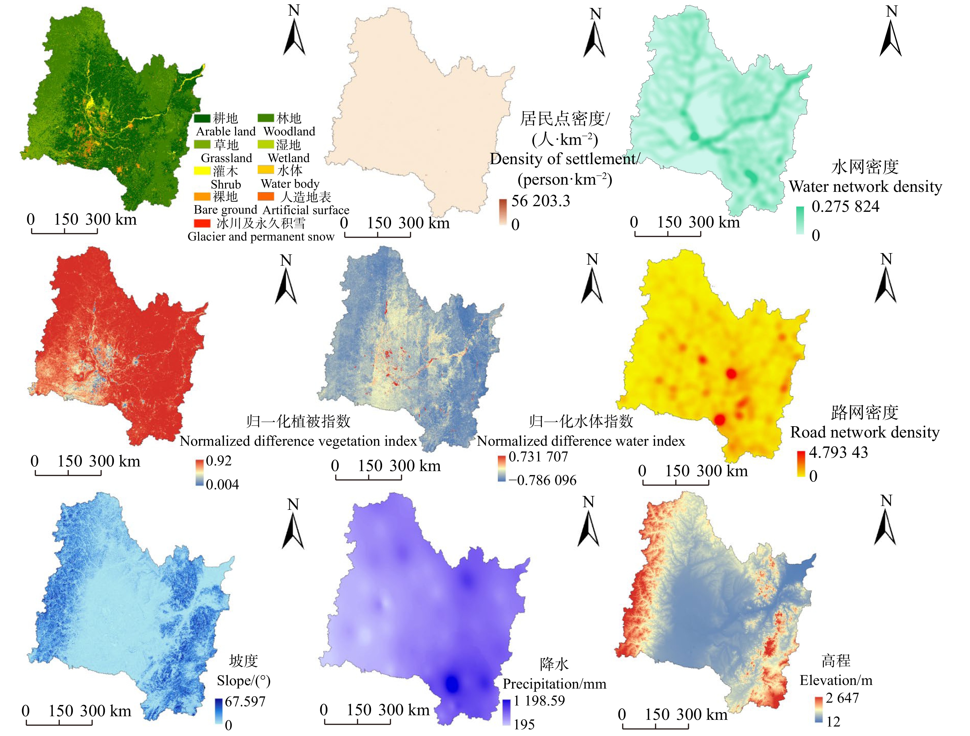
松花江流域区划数据来源于中国科学院资源环境科学与数据中心(http://www.resdc.cn/);土地利用数据来源于自然资源部向社会发布的2020年30 m全球地表覆盖数据(www.globallandcover.com/),包括耕地、森林、草地、灌木、湿地、水体、苔原、人造地表、裸地、冰川及永久积雪10种地表覆盖类型数据;路网数据、水网数据来源于Open Street Map(http://www.openstreetmap.org/),通过ArcGIS对该数据进行线密度分析得到空间分辨率为30 m的水网密度、路网密度;数字高程模型(digital elevation model, DEM)数据来源于地理空间数据云(http://www.gscloud.cn/),空间分辨率30 m,通过ArcGIS坡度分析得到坡度数据;归一化植被指数(normalized difference vegetation index, NDVI)、归一化水体指数(normalized difference water index, NDWI)数据来源于Google Earth Engine(http://code.earthengine.google.com/)平台,选取2020年夏季少云的Landsat8数据计算求得,空间分辨率为30 m;居民点数据来源于各个省份统计年鉴整理获得,通过ArcGIS核密度分析,得到空间分辨率为30 m的居民点密度数据;2020年平均降水量来源于国家气象科学数据中心(http://data.cma.cn),然后通过ArcGIS克里金插值。得到空间分辨率为30 m的降水量数据。
1.3 生态网络的构建
1.3.1 生态源地提取
生态源地是物质循环、能量流动、信息交流主要场所[16],具有重要的生态系统服务。依据研究区地类划分,提取林地、草地、灌木、湿地、水体5种具有重要生态意义的地类,以斑块面积、平均NDVI、平均NDWI、斑块形状指数4个指标筛选生态源地,其中斑块面积、平均NDVI和平均NDWI通过ArcGIS软件计算得到,斑块形状指数通过Fragstat4.2分析得到[17]。运用熵值法对4个指标赋权[18]分别为0.6、0.1、0.1、0.2,使用栅格计算器对不同斑块指标进行累加,得到各个斑块权重,按照斑块的重要程度提取生态源地。
1.3.2 生态网络阻力面构建
生态系统中物质循环、能量流动、信息传递需要克服生态阻力去完成。生态阻力受多种因素的影响[19],本文选取DEM、坡度、NDVI、NDWI、降水量、人口密度、水网密度、路网密度、土地利用类型共9种不同生态阻力因子(图2)。
参考前人研究成果[20-23]并结合研究区生态环境,构建生态阻力评价体系(表1)。将不同生态阻力因子划分为1、2、3、4、5共5个等级。考虑到不同阻力因子对研究区生态空间网络的维持与发展有必不可少的贡献,所以不同阻力因子具有相同的权重。
表 1 生态因子及阻力值Table 1. Ecological factors and resistance values一级影响因子
Primary impact factor二级影响因子
Secondary impact factor分类
Classification阻力值
Resistance value地形坡度
Terrain slope高程
Elevation/m12 ~ 255 1 255 ~ 436 2 436 ~ 650 3 650 ~ 923 4 923 ~ 2 647 5 坡度
Slope/(°)0 ~ 3.4 1 3.4 ~ 7.8 2 7.8 ~ 13.3 3 13.3 ~ 20.0 4 > 20.0 5 植被覆盖
Vegetation cover归一化植被指数
Normalized difference
vegetation index0.74 ~ 1.00 1 0.60 ~ 0.74 2 0.39 ~ 0.60 3 0 ~ 0.39 4 < 0 5 水文分布
Hydrological distribution归一化水体指数
Normalized difference
water index< 0 5 0 ~ 0.24 4 0.24 ~ 0.52 3 0.52 ~ 0.76 2 0.76 ~ 1 1 土地覆盖
Land cover土地利用
Land use林地 Woodland 1 草地 Grassland 1 水体 Water body 1 湿地 Wetland 2 灌木 Shrub 2 耕地 Arable land 3 人造地表 Artificial surface 4 裸地 Bare ground 4 苔原 Tundra 4 冰川及永久积雪
Glacier and permanent snow5 密度因子
Density factor水网密度
Water network density0 ~ 0.02 5 0.02 ~ 0.05 4 0.05 ~ 0.08 3 0.08 ~ 0.13 2 0.13 ~ 0.27 1 路网密度
Road network density0 ~ 0.2 1 0.2 ~ 0.5 2 0.5 ~ 1.0 3 1.0 ~ 2.4 4 2.4 ~ 4.7 5 居民点密度/(人·km−2)
Density of settlement/(person·km−2)0 ~ 219 1 220 ~ 1 536 2 1 536 ~ 6 147 3 6 147~ 27 662 4 27 662 ~ 56 203 5 降雨
Rainfall降水量
Precipitation/mm818 ~ 1 198 1 626 ~ 818 2 512 ~ 626 3 391 ~ 512 4 195 ~ 391 5 MCR模型表示一个生态源地到另一个生态源地所克服的最小阻力,每一个生态源地具有不同的生态能量,它们所传输的能量及信息各不相同[24],文中基于不同的阻力因子构建阻力面,源地之间的阻力越大则说明两个生态源地之间物质循环、能量流动、信息交流就越困难。MCR模型一般表达式为:
Tmcr=fmini=m∑j=n(DijRi) (1) 式中:
Tmcr 表示最小累积阻力值;fmin 表示单位土地累积阻力的最小值;Dij 表示从起始源地i 到最终目标景观单元j 的空间距离,Ri 表示用地单元i 运动过程消耗的阻力。1.3.3 潜在生态廊道提取
生态廊道一般是指生态环境中呈带状或线状布局,连接空间分布较为孤立和分散的生态单元[25]。生态廊道的构建依据能量传递消耗最小的路径,通过Cost-path计算得到松花江流域潜在生态廊道[26]。
1.4 引力模型
引力模型最早由地理学家、社会学家与经济学家为了解释和预测人类在地理空间上的经济、社会以及政治性相互影响与相互作用方式,利用经典力学中的万有引力公式建立的一种理论假说[27],本文基于引力模型定量评估斑块之间作用强度,来判定生态廊道的相对重要性。引力模型表达式如下:
Tab=NaNbF2ab=(1Ga×lnSa)×(1Gb×lnSb)(LabLmax (2) 式中:Tab表示两个斑块之间的引力;Na和Nb表示两个斑块的权重;Fab
表示两个斑块廊道之间的累计阻力值; L_{\max } 表示生态廊道的最大阻力值;{S_a} 、{S_b} 表示斑块的面积;{G_a} 、{G_b} 表示两个斑块的阻力,L_{{\rm{ab}}} 表示a、b斑块之间的阻力值。本文将引力模型计算出廊道之间的引力,类比为复杂网络中的边权引入生态网络。对生态廊道赋予边权。1.5 生态空间网络拓扑结构
生态空间网络由生态源地以及生态廊道相互连接构建,本文将复杂网络拓扑特征延伸到生态空间网络。基于复杂网络拓扑指标去揭示生态空间网络的拓扑结构,研究不同生态源地的连接特征,识别关键生态节点与生态廊道,为生态空间网络的构建与优化提供对应的优化思路。因此,本文选取度、点权、鲁棒性,计算各指数在生态空间优化前后网络崩溃阈值的变化。各指数计算见参考文献[28-32]。
1.6 生态空间网络权−度增边优化
权−度相关性指的是对于单个节点来说,其点权和度之间的相关性。在生态空间网络中权−度相关性研究的是生态源地之间的连通性与廊道重要性[19]。生态源地权−度相关性表达式如下:
S_{vv}(i) = \dfrac{{\displaystyle\sum\limits_{i \in k} {S_i} }}{{N \cdot P(i)}} (3) 式中:
N 为节点总数;P(i) 为度分布函数,S_i 为生态节点的点权,k 为生态节点的度,i 为生态节点。文中借助赋权网络中的点权来计算生态源地重要程度,通过生态网络中节点的“度”,分析生态空间网络中权−度相关性,重点针对廊道空白区域和生态源地“度”值较低源地,然后对生态空间网络增边优化。
2. 结果与分析
2.1 生态源地选取
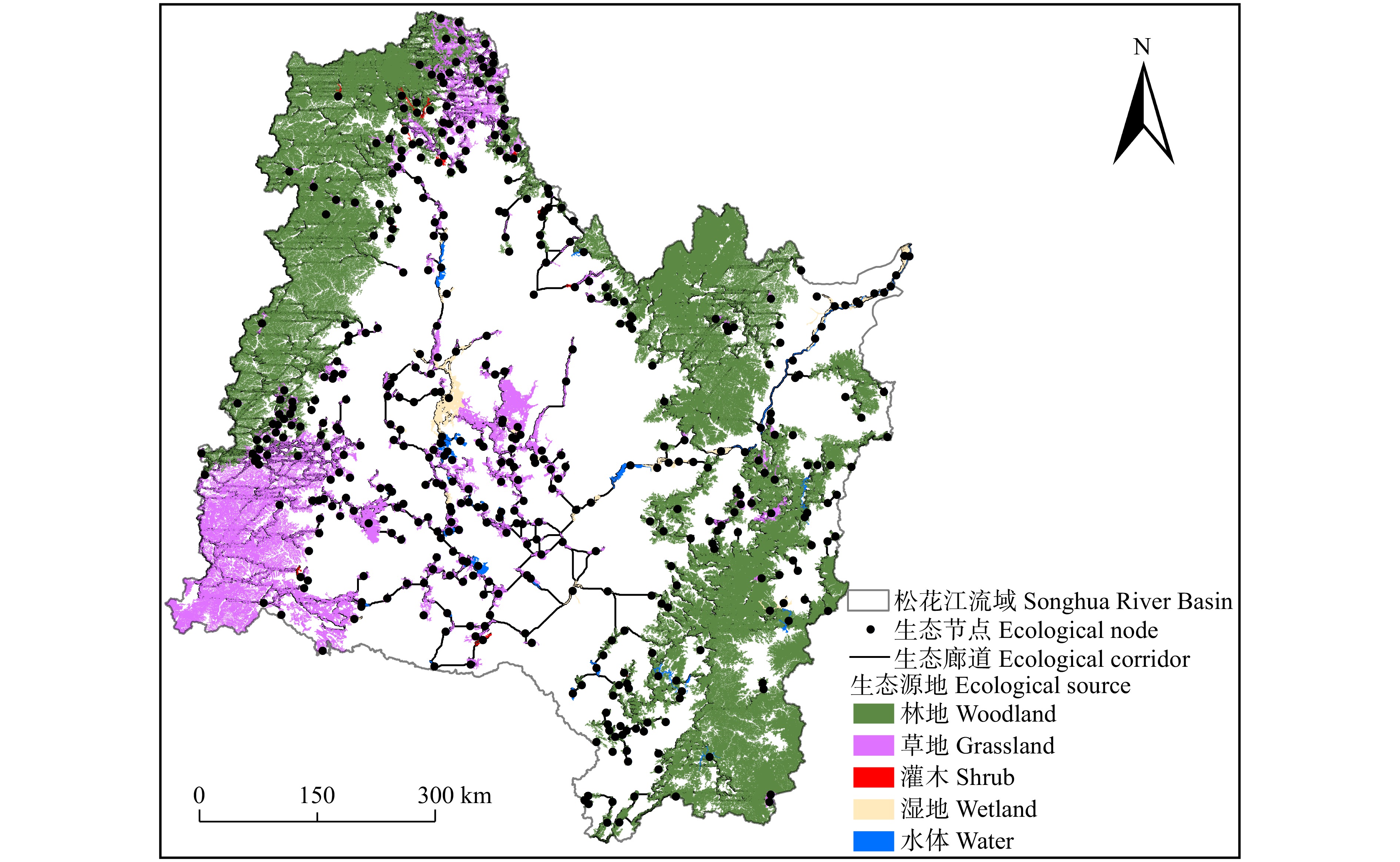
松花江流域土地利用类型主要以耕地、林地、草地为主,分别占总面积的42.25%、33.37%和17.81%。选取林地、草地、灌木、湿地、水体作为生态源地,在大尺度研究区域内,剔除一些面积较小的草地、林地斑块,保留一些面积较小且生态学意义较为显著的图斑,如水体、湿地等,选取生态源地450个,总面积为214 555 km2,其中林地源地162个、草地源地198个、灌木源地19个、湿地源地34个、水体源地41个(图3)。
生态源地以林地和草地为主,林地主要分布在流域的西北、东北、东南区域,草地主要分布在流域的东南区域,灌木、湿地、水体斑块零星分布在流域中部且源地数量较少。
2.2 生态空间网络的构建
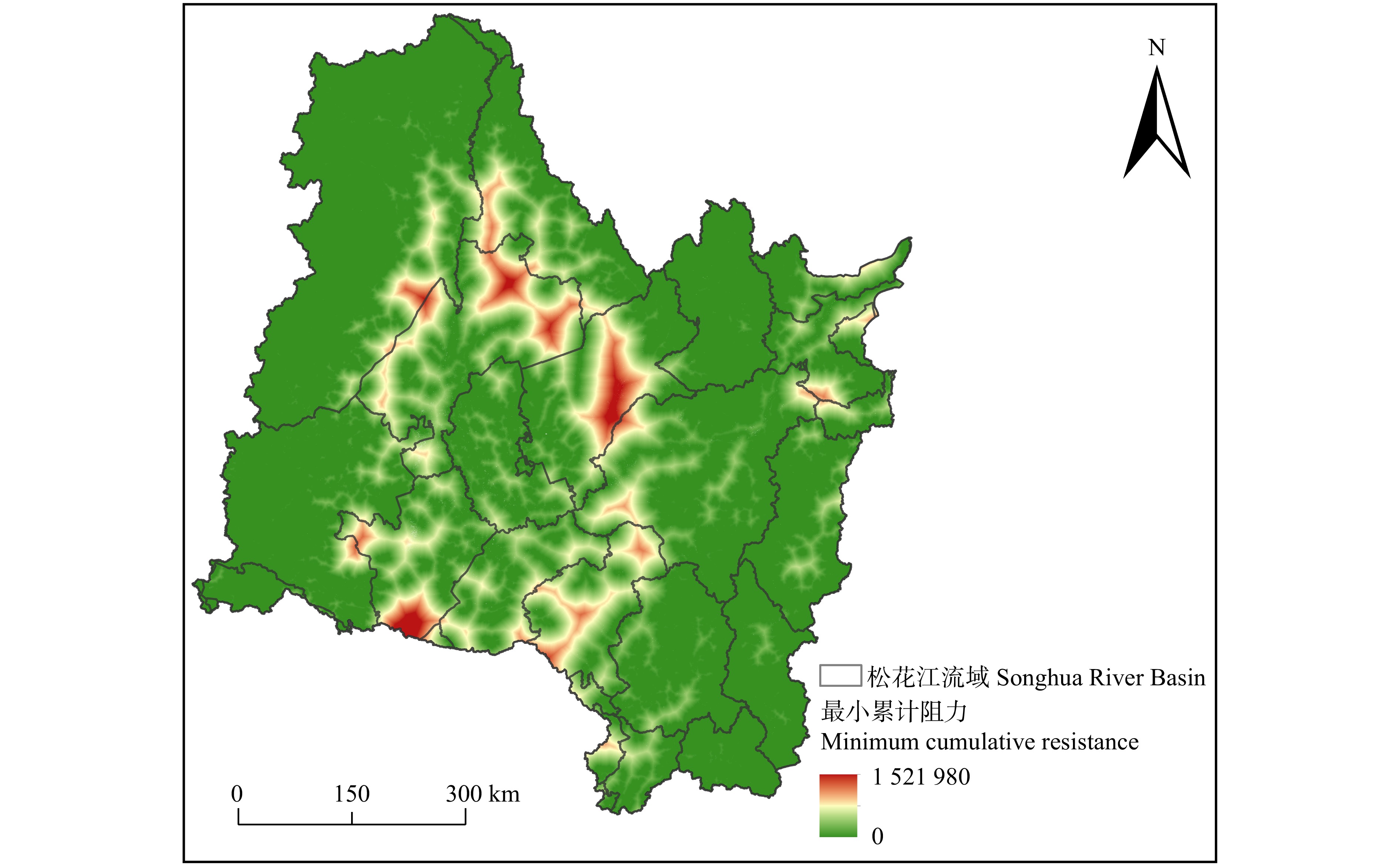
研究区生态阻力由多种阻力因子构成。本文选取9种阻力因子进行叠加分析,得到研究区累积阻力面(图4)。潜在生态廊道208 290条,剔除重叠生态廊道,最终得到1 019条直接相连的生态廊道(图5)。
研究区生态阻力值较大区域分布在齐齐哈尔市、绥化市、长春市、哈尔滨市、白城市,这些城区地势平坦,人口密度大,景观类型破碎程度高,建设用地集中,构成明显的生态屏障区,而且生态源地较为分散,生态廊道连接度低,潜在生态廊道单一,连接度明显不够,生态网络稳定性差。
生态阻力值较小区域分布在呼伦贝尔市、兴安盟、伊春市、白山市、牡丹江市。这些区域有大小兴安岭、长白山,森林覆盖度较高,而且有大面积草原。嫩江、松花江、牡丹江都流经该区域,水网密集,生态源地分布集中,生态廊道错综复杂,生态网络的稳定性较高。
整体看来,松花江流域生态阻力值由边缘区域向中部城区逐渐增大,生态廊道分布不均衡。中部城区生态廊道连通度较低,生态节点较为稀疏。而西北、西南、东南区域生态廊道连通性较高,生态节点密度高,形成明显的两极分化。
2.3 引力模型分析
生态源地间相互作用强度越大,表明物质循环、能量流动,信息传递就越复杂,生态源地之间的作用强度具有显著的差异性。文中将研究区生态廊道分为重要廊道、次要廊道,其中重要廊道是引力在2000以上,次要廊道引力在100 ~ 2000之间。重要廊道主要集中在大兴安岭、小兴安岭、长白山、以及流域中部连接边缘区域,表明这几个区域生态系统功能强大,有利于不同廊道之间能量流动及信息的传递。其中,源地之间引力最小的区域位于哈尔滨市,该区域生态环境质量差,主要是城镇化发展导致斑块破碎化程度加剧,物种的栖息地遭到严重的破坏,能量的传输受到不同程度的阻碍,影响了区域可持续发展。因此,有必要针对该区域生态空间网络进行优化。
2.4 节点度的分析
将研究区不同生态节点之间的连线生成邻接矩阵,通过Matlab软件得到生态节点的度、平均度(图6),可以看出生态网络度的分布呈现出幂律分布。而其Poisson网络分布特征不够明显,表明生态网络的无标度网络特征更加明显。节点度的最大值为11,数量1个,节点度的最小值为1,数量15个。节点度的平均值为4.52。节点度主要集中在3、4、5数值,在整个生态网络中,节点度值越大说明整个生态网络的连通性越高,生态系统服务更加复杂。
2.5 权−度增边优化
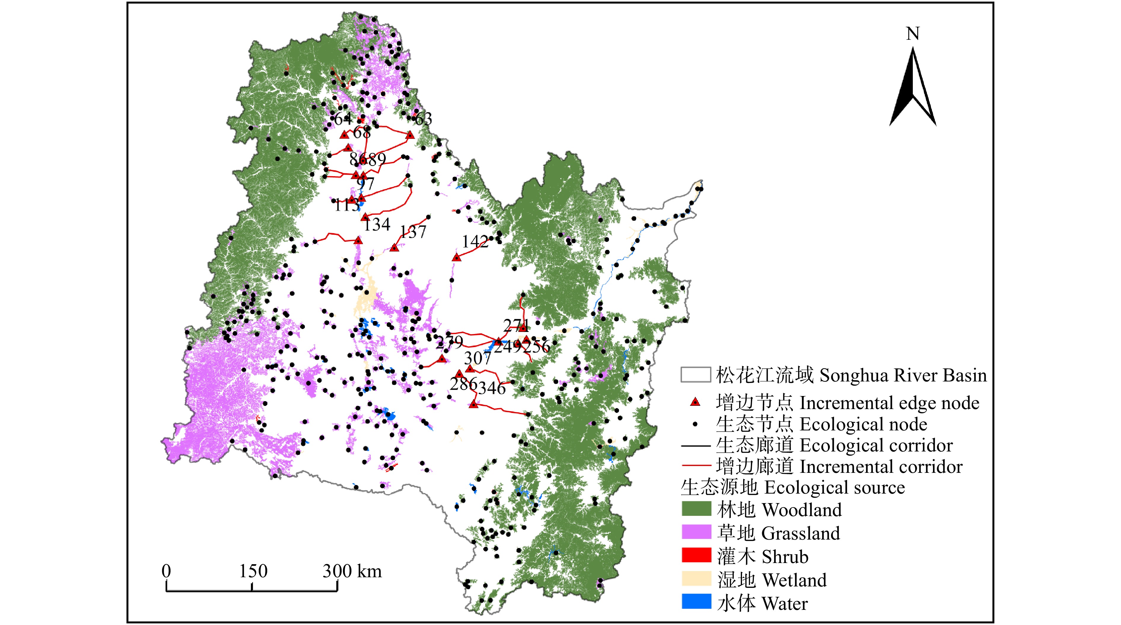
松花江流域东北、西北、中部区域生态源地之间出现廊道空白,生态能量流动受到阻碍,生态空间网络有待优化。根据增边策略计算东北、东南区域节点源地权重和度值,筛选得出生态源地64、68、101、113、134、242、256、271、286、307源地权重较大。这几个生态源地度值分别是3、4、3、2、2、4、3、2、3。其中,节点度值大于3节点数量占整个生态网络的67%,表明这几个生态源地在松花江流域重要性程度高,但这几个源地“度”值低,说明区域生态空间网络连通性差。这几个源地是连接呼伦贝尔市、齐齐哈尔市、哈尔滨市、绥化市、大庆市关键的生态廊道。基于增边优化策略,对松花江流域东北、西北、中部所连接的生态空间网络增边优化,东北与中部相连城市是大兴安岭和齐齐哈尔市,增边优化节点11个,增边12条。西北与中部相连城市是哈尔滨市和大庆市、绥化市,增边优化节点9个,增边12条。增边优化有助于增强生态网络的稳定性,增强松花江流域生态能量流动(图7)。
![]() 图 7 研究区模拟增边优化图上数字为筛选出的权重较大的源地。Data in the figure represent those sources with high weights.Figure 7. Simulation edging optimization in the study area
图 7 研究区模拟增边优化图上数字为筛选出的权重较大的源地。Data in the figure represent those sources with high weights.Figure 7. Simulation edging optimization in the study area2.6 鲁棒性分析
2.6.1 连接鲁棒性分析
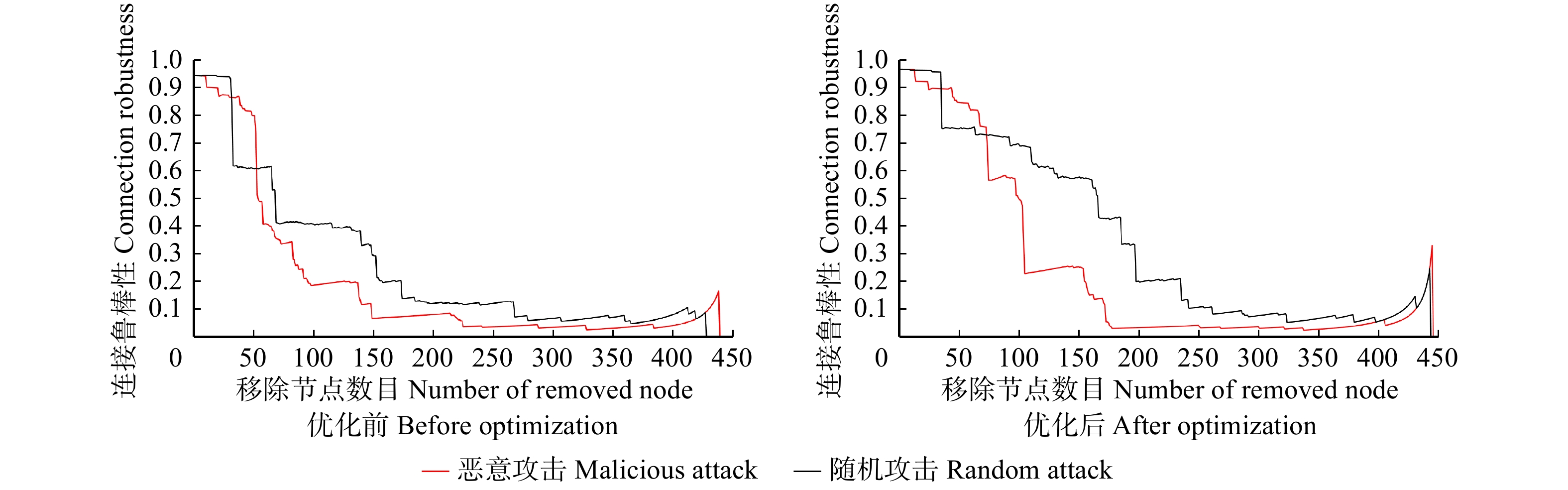
松花江流域优化前潜在生态廊道连接鲁棒性(图8),连接鲁棒性的初始值为0.94,恶意攻击情况下,当生态节点移除数目49时,连接鲁棒性出现了骤然下降,鲁棒性数值从0.81下降到0.40。当生态节点数目移除达到150时,网络连接鲁棒性为0.07,此时生态空间网络的连通性极低,生态空间网络能量流基本丧失。生态空间网络在随机攻击情况下,生态节点移除数目为25个,生态空间网络的鲁棒性骤然下降,连接鲁棒性数值从0.92直接下降到0.70,然后趋于缓慢下降,生态节点在移除数目达到260时,网络鲁棒性为0.09,这时随机攻击下的生态网络才表现出网络结构崩溃。从优化前生态网络连接鲁棒性可以看出,随机网络移除生态节点数目为53时,恶意攻击的鲁棒性数值要大于随机攻击鲁棒性数值,但是在移除53个生态节点之后,连接鲁棒性的恶意攻击要比随机攻击最先达到生态网络崩溃阈值。
![]() 图 8 增边优化前后连接鲁棒性变化Figure 8. Connection robustness changes before and after edging optimization
图 8 增边优化前后连接鲁棒性变化Figure 8. Connection robustness changes before and after edging optimization优化后的生态网络(图8),连接鲁棒性初始值为0.97,优化后生态网络连接鲁棒性有一定的提高,对其进行恶意攻击,可以看出连接鲁棒性有两次急剧下降,第一次急剧下降是在移除节点数目为67时,连接鲁棒性数值从0.81下降到0.57,第二次断崖式下降是在移除节点数目为97时,连接鲁棒性数值从0.57下降到0.23,当移除节点到达173时,网络鲁棒性为0.06,这时生态网络的连通性基本完全崩溃。优化后的生态网络在恶意攻击下,连接鲁棒性有了提升,但是提升效果一般。优化后的生态网络在随机攻击下,生态网络在移除115个生态节点之前,连接鲁棒性数值仅从0.97下降到0.85,相对于优化前生态网络的连接鲁棒性有了很大提升。当移除生态节点数目到达339时,网络连接鲁棒性才降低到0.10,对比没有优化前,增加了79个生态节点。而且优化后的生态网络在随机攻击下连接鲁棒性数值一直大于恶意攻击下的连接鲁棒性。
综上所述,优化后的生态空间网络连接鲁棒性得到了明显的提高,说明了通过点权和“度”结合分析,对研究区生态空间网络增边优化,增强了生态空间网络的连通性,改善了研究区的生态环境。
![]() 图 9 增边优化前后节点恢复鲁棒性变化Figure 9. Robustness changes of node recovery before and after edging optimization
图 9 增边优化前后节点恢复鲁棒性变化Figure 9. Robustness changes of node recovery before and after edging optimization2.6.2 恢复鲁棒性
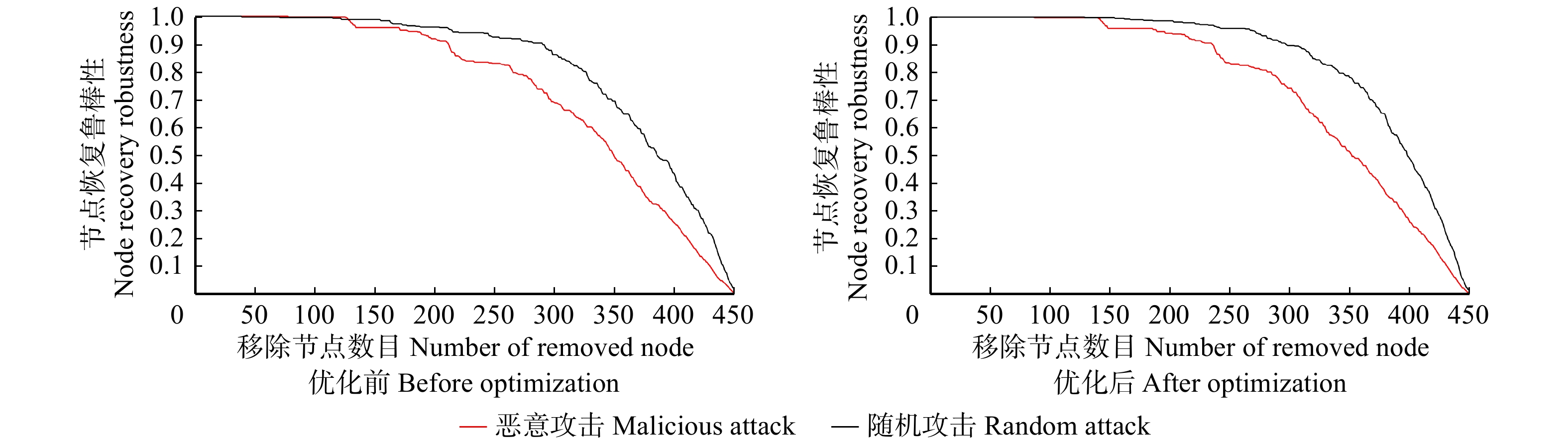
针对研究区优化前后节点恢复鲁棒性进行分析(图9),优化前节点恢复鲁棒性(恶意攻击、随机攻击)数值为1,在恶意攻击下移除节点数目78个,随机攻击下移除节点数目92个,是两种攻击完全恢复生态网络的最大移除节点数目。两种攻击情况下,节点恢复鲁棒性都呈现逐渐下降的趋势,其中恶意攻击下降速率要大于随机攻击的下降速率,在恶意攻击、随机攻击的情况下,当移除节点数目分别达到430、443时,网络的节点恢复鲁棒性都低于0.10,网络几乎崩溃。对优化后的网络进行分析(两种攻击(恶意攻击、随机攻击)完全恢复生态节点的最大移除节点数目分别为89、123个。在两种攻击(恶意攻击、随机攻击)移除节点数目到达433、448时,网络才近乎崩溃。对比优化前后的生态网络,网络优化后,在恶意攻击、随机攻击情况下可以完全恢复生态网络的最大移除节点数目有了明显提升,但其生态崩溃阈值基本没变。
针对优化前后的边恢复鲁棒性进行分析(图10),优化前边恢复鲁棒性(恶意攻击、随机攻击)数值为1,在恶意攻击下移除节点数目3个,在随机攻击下移除节点数目15个,是两种攻击完全恢复生态网络的最大移除节点数目。在两种攻击的情况下,其中恶意攻击下降的速率要大于随机攻击。在恶意攻击、随机攻击情况下,当移除节点分别达到365、430,网络的边恢复鲁棒性均低于0.10,网络几乎崩溃,对优化后的网络进行分析,在恶意攻击、随机攻击情况下完全恢复边的最大移除节点数目分别为10、35时,在恶意攻击、随机攻击情况下,当移除节点分别达到397、449,网络的边恢复鲁棒性均低于0.10,网络才近乎崩溃,对比优化前后的生态网络,在恶意攻击、随机攻击情况下可以完全恢复生态网络的最大移除节点数目分别提升了7、20个,其生态崩溃阈值也有很大提高。
![]() 图 10 增边优化前后边恢复鲁棒性变化Figure 10. Before and after edge enhancement optimization to recover robust changes
图 10 增边优化前后边恢复鲁棒性变化Figure 10. Before and after edge enhancement optimization to recover robust changes综上所述,生态空间网络增边优化后,在3种不同的鲁棒性分析中生态空间网络的流通性、稳定性都有不同程度的提升,增边优化对连接鲁棒性上的提升比对节点恢复鲁棒性、边恢复鲁棒性的提升效果更好。
3. 讨 论
依据松花江流域生态斑块空间格局分析,研究区边缘生态斑块面积大,破碎化程度小。研究区中部生态斑块面积小且破碎化程度严重(图2),中部区域人口密度大。分析松花江流域生态空间网络,不同区域生态斑块存在明显空间分布不均衡现象,与徐伟振等[33]对厦门市生态网络的分析中得到了相同结果。人类活动强度较高的区域,斑块之间连通度较低,生态质量普遍较差[34]。间接反映出人类活动强度对松花江流域生态系统造成了负面的影响。
基于引力模型分析,将生态廊道分为重要廊道、次要廊道[35-36]。重要廊道之间连接源地为大面积林地和草地,生态廊道距离短,而且对生物多样性的保护形成一个天然屏障[37]。主要位于大兴安岭、小兴安岭、长白山、呼伦贝尔草原。在生态文明建设中,属于重点生态保护用地。次要廊道主要位于齐齐哈尔市、大庆市、白城市、松原市等,廊道之间连接源地主要为小面积的林地、水域、草地,特别是在湿地和水域周围土壤水分含量较高但其周围林地和草地斑块呈现出明显破碎化,各个斑块之间联系也较为薄弱,在未来生态安全保护,借鉴Guo等[38]文中提到增加“踏脚石”来加强生态斑块的分布。
针对松花江流域生态空间网络分析,边缘区域生态网络错综复杂,中部区域生态网络廊道单一且出现明显断裂。特别是呼伦贝尔市、黑河市、齐齐哈尔市3个城市之间连接的廊道出现明显空白现象,由最小累积阻力面看出齐齐哈尔市区域生态阻力极大,通过不同的生态阻力因子分析,发现齐齐哈尔区域被大面积耕地覆盖,严重阻碍生态能量流动而且区域生态斑块严重破碎化,考虑生态能量流动遵循最小阻力原则,能量可能通过大兴安岭、小兴安岭、长白山流动,而齐齐哈尔市耕地区域生态阻力大而导致能量流动受到阻碍。这与谢婧等[39]分析齐齐哈尔市生态空间网络得到了相同的结果。齐齐哈尔市耕地面积面积较大,作为人类干扰过程较强的区域,可能会对斑块内小型草地产生干扰破坏[40-41]。所以在未来生态文明建设,可以对这种薄弱型生态源地增边优化,来有效促进生态空间网络的循环、维护区域生态系统结构和功能的完整性。
针对松花江流域生态空间网络进行优化,本文侧重于理论研究。增边优化区域是否可以通过修建沟渠,或在道路两侧增加防护林方式实现,需要理论知识结合实际做实地调查,并且结合松花江流域因地制宜的原则,去具体实现松花江流域增边优化方式。这将是笔者下一步需要探索的内容。
4. 结 论
(1)松花江流域提取生态源地450个,总面积为21.46万km2,源地主要以林地、草地为主, 结合GIS空间分析和MCR模型构建生态网络,获取1019条生态廊道,位于大兴安岭、小兴安岭、长白山区域的生态廊道分布密集,但是位于研究区中部的齐齐哈尔市、哈尔滨市、大庆市、绥化市、白城市、松原市生态廊道稀疏。
(2)基于复杂网络理论,计算生态源地的权重和生态源地的“度”。结合研究区生态廊道空白区域进行权−度相关性分析,筛选出廊道空白区域的增边节点,对其增边优化,共识别增边节点20个,增边24条。
(3)依据复杂网络的鲁棒性分析,通过不同的攻击方式下生态网络的连接鲁棒性和恢复鲁棒性的变化,对比优化前后生态网络的恢复鲁棒性,可以明显看出生态网络优化前和生态网络优化后其恢复鲁棒性没有明显的提高,但是对于连接鲁棒性却有很大的优化。特别是连接鲁棒性在随机攻击情况下变化更加显著。总体看来,增边优化后的研究区显著提高生态网络的连通性、抗干扰能力,生态流动的传输性会更加明显。
-
![]()
图 7 研究区模拟增边优化
图上数字为筛选出的权重较大的源地。Data in the figure represent those sources with high weights.
Figure 7. Simulation edging optimization in the study area
![]()
图 8 增边优化前后连接鲁棒性变化
Figure 8. Connection robustness changes before and after edging optimization
![]()
图 9 增边优化前后节点恢复鲁棒性变化
Figure 9. Robustness changes of node recovery before and after edging optimization
![]()
图 10 增边优化前后边恢复鲁棒性变化
Figure 10. Before and after edge enhancement optimization to recover robust changes
表 1 生态因子及阻力值
Table 1 Ecological factors and resistance values
一级影响因子
Primary impact factor二级影响因子
Secondary impact factor分类
Classification阻力值
Resistance value地形坡度
Terrain slope高程
Elevation/m12 ~ 255 1 255 ~ 436 2 436 ~ 650 3 650 ~ 923 4 923 ~ 2 647 5 坡度
Slope/(°)0 ~ 3.4 1 3.4 ~ 7.8 2 7.8 ~ 13.3 3 13.3 ~ 20.0 4 > 20.0 5 植被覆盖
Vegetation cover归一化植被指数
Normalized difference
vegetation index0.74 ~ 1.00 1 0.60 ~ 0.74 2 0.39 ~ 0.60 3 0 ~ 0.39 4 < 0 5 水文分布
Hydrological distribution归一化水体指数
Normalized difference
water index< 0 5 0 ~ 0.24 4 0.24 ~ 0.52 3 0.52 ~ 0.76 2 0.76 ~ 1 1 土地覆盖
Land cover土地利用
Land use林地 Woodland 1 草地 Grassland 1 水体 Water body 1 湿地 Wetland 2 灌木 Shrub 2 耕地 Arable land 3 人造地表 Artificial surface 4 裸地 Bare ground 4 苔原 Tundra 4 冰川及永久积雪
Glacier and permanent snow5 密度因子
Density factor水网密度
Water network density0 ~ 0.02 5 0.02 ~ 0.05 4 0.05 ~ 0.08 3 0.08 ~ 0.13 2 0.13 ~ 0.27 1 路网密度
Road network density0 ~ 0.2 1 0.2 ~ 0.5 2 0.5 ~ 1.0 3 1.0 ~ 2.4 4 2.4 ~ 4.7 5 居民点密度/(人·km−2)
Density of settlement/(person·km−2)0 ~ 219 1 220 ~ 1 536 2 1 536 ~ 6 147 3 6 147~ 27 662 4 27 662 ~ 56 203 5 降雨
Rainfall降水量
Precipitation/mm818 ~ 1 198 1 626 ~ 818 2 512 ~ 626 3 391 ~ 512 4 195 ~ 391 5  下载: 导出CSV
-
[1] 张媛媛. 中国城镇化发展对生态环境的影响研究[D]. 长春: 吉林大学, 2017. Zhang Y Y. Study on the influence of urbanization development to ecological environment in China[D]. Changchun: Jilin University, 2017.
[2] Song S, Xu D, Hu S, et al. Ecological network optimization in urban central district based on complex network theory: a case study with the urban central district of Harbin[J/OL]. International Journal of Environmental Research and Public Health, 2021, 18(4): 1427 [2021−08−11]. https://www.mdpi.com/1660-4601/18/4/1427
[3] 赵丹阳. 松花江流域城镇空间扩展的生态环境效应[D]. 北京: 中国科学院大学, 2017. Zhao D Y. Eco-environment effect of urban expansion in Songhua River Basin[D]. Beijing: University Chinese Academy of Science, 2017.
[4] 张鹏, 李世峰, 刘瑶瑶. 基于生态适宜性分析的平原煤矿县生态空间优化[J]. 农业工程学报, 2019, 35(19): 274−282. doi: 10.11975/j.issn.1002-6819.2019.19.034 Zhang P, Li S F, Liu Y Y. Ecological space optimization of plain coal mine county based on ecological suitability analysis[J]. Transactions of the Chinese Society of Agricultural Engineering, 2019, 35(19): 274−282. doi: 10.11975/j.issn.1002-6819.2019.19.034
[5] 赵晓峰, 王金林, 王珊珊, 等. 基于MCR模型的卡拉麦里地区生态安全格局变化研究[J]. 干旱区地理, 2021, 44(5): 1396−1406. doi: 10.12118/j.issn.10006060.2021.05.20 Zhao X F, Wang J L, Wang S S, et al. Changes of ecological security pattern in Kalamaili region based on MCR models[J]. Arid Land Geography, 2021, 44(5): 1396−1406. doi: 10.12118/j.issn.10006060.2021.05.20
[6] 陈南南, 康帅直, 赵永华, 等. 基于MSPA和MCR模型的秦岭(陕西段)山地生态网络构建[J]. 应用生态学报, 2021, 32(5): 1545−1553. Chen N N, Kang S Z, Zhao Y H, et al. Construction of ecological network in Qinling Mountains of Shaanxi, China based on MSPA and MCR model[J]. Chinese Journal of Applied Ecology, 2021, 32(5): 1545−1553.
[7] Zhao S M, Ma Y F, Wang J L, et al. Landscape pattern analysis and ecological network planning of Tianjin City[J/OL]. Urban Forestry & Urban Greening, 2019, 46: 126479[2021−08−11]. https://www.sciencedirect.com/science/article/pii/S1618866719302602.
[8] 莫惠萍, 林美玲, 胡欣雨, 等. 基于MSPA和MCR的土地生态适宜性评价: 以韶关市始兴县为例[J]. 黑龙江生态工程职业学院学报, 2021, 34(4): 20−25, 29. doi: 10.3969/j.issn.1674-6341.2021.04.006 Mo H P, Lin M L, Hu X Y, et al. Evaluation of land ecological suitablity based on GIS and least cumulative resistance model: a case study of Shixing County, Shaoguan City[J]. Journal of Heilongjiang Vocational Institute of Ecological Engineering, 2021, 34(4): 20−25, 29. doi: 10.3969/j.issn.1674-6341.2021.04.006
[9] 李恒凯, 刘玉婷, 李芹, 等. 基于MCR模型的南方稀土矿区生态安全格局分析[J]. 地理科学, 2020, 40(6): 989−998. Li H K, Liu Y T, Li Q, et al. Analysis of ecological security pattern of southern rare earth mining area based on MCR model[J]. Scientia Geographica Sinica, 2020, 40(6): 989−998.
[10] 吴钰茹, 吴晶晶, 毕晓丽, 等. 综合最小耗费距离模型与电路理论模型方法评估黄河三角洲湿地景观连通性[J]. 生态学报, 2022, 42(4): 1−12. Wu Y R, Wu J J, Bi X L, et al. Application of the least cost distance model and the circuit theory model in the evaluation of wetland landscape connectivity in the Yellow River Delta[J]. Acta Ecologica Sinica, 2022, 42(4): 1−12.
[11] 汉瑞英, 赵志平, 肖能文. 生物多样性保护优先区生态网络构建与优化: 以太行山片区为例[J]. 西北林学院学报, 2021, 36(2): 61−67. doi: 10.3969/j.issn.1001-7461.2021.02.09 Han R Y, Zhao Z P, Xiao N W. The eco-network construction and optimization in biodiversity conservation priority area: a case study of the Taihang Mountain area[J]. Journal of Northwest Forestry University, 2021, 36(2): 61−67. doi: 10.3969/j.issn.1001-7461.2021.02.09
[12] 沈钦炜, 林美玲, 莫惠萍, 等. 佛山市生态网络构建及优化[J]. 应用生态学报, 2021, 32(9): 3288−3298. doi: 10.13287/j.1001-9332.202109.019 Shen Q W, Lin M L, Mo H P, et al. Ecological network construction and optimization in Foshan City, China[J]. Chinese Journal of Applied Ecology, 2021, 32(9): 3288−3298. doi: 10.13287/j.1001-9332.202109.019
[13] 于强, 杨澜, 岳德鹏, 等. 基于复杂网络分析法的空间生态网络结构研究[J]. 农业机械学报, 2018, 49(3): 214−224. doi: 10.6041/j.issn.1000-1298.2018.03.026 Yu Q, Yang L, Yue D P, et al. Investigation on complex spatial ecological network structure based on complex network analysis method[J]. Transactions of the Chinese Society for Agricultural Machinery, 2018, 49(3): 214−224. doi: 10.6041/j.issn.1000-1298.2018.03.026
[14] Yu Q, Yue D, Wang Y, et al. Optimization of ecological node layout and stability analysis of ecological network in desert oasis: a typical case study of ecological fragile zone located at Dengkou County (Inner Mongolia)[J]. Ecological Indicators, 2018, 84(1): 304−318.
[15] Wang K, Guo X, Wang M, et al. Gravity model toolbox: an automated and open-source ArcGIS tool to build and prioritize ecological corridors in urban landscapes[J/OL]. Global Ecology and Conservation, 2020, 22: e01012[2022−08−31]. https://doi.org/10.1016/j.gecco.2020.e01012.
[16] 吴健生, 张理卿, 彭建, 等. 深圳市景观生态安全格局源地综合识别[J]. 生态学报, 2013, 33(13): 4125−4133. doi: 10.5846/stxb201208081123 Wu J S, Zhang L Q, Peng J, et al. The integrated recognition of the source area of the urban ecological security pattern in Shenzhen[J]. Acta Ecologica Sinica, 2013, 33(13): 4125−4133. doi: 10.5846/stxb201208081123
[17] 牛腾, 岳德鹏, 张启斌, 等. 潜在生态网络空间结构与特性研究[J]. 农业机械学报, 2019, 50(8): 166−175. doi: 10.6041/j.issn.1000-1298.2019.08.019 Niu T, Yue D P, Zhang Q B, et al. Spatial structure and characteristics of potential ecological networks[J]. Transactions of the Chinese Society for Agricultural Machinery, 2019, 50(8): 166−175. doi: 10.6041/j.issn.1000-1298.2019.08.019
[18] 裴燕如, 武英达, 于强, 等. 荒漠绿洲区潜在生态网络增边优化鲁棒性分析[J]. 农业机械学报, 2020, 51(2): 172−179. doi: 10.6041/j.issn.1000-1298.2020.02.019 Pei Y R, Wu Y D, Yu Q, et al. Robust analysis of potential ecological network ecological network edge enhancement in desert oasis area[J]. Transactions of the Chinese Society for Agricultural Machinery, 2020, 51(2): 172−179. doi: 10.6041/j.issn.1000-1298.2020.02.019
[19] 张启斌. 乌兰布和沙漠东北缘生态网络构建与优化研究[D]. 北京: 北京林业大学, 2019. Zhang Q B. Study on the construction and optimization of ecological network in the northeastern margin of Ulan Buhe Desert [D]. Beijing: Beijing Forestry University, 2019.
[20] 于强. 基于复杂网络理论的荒漠绿洲区生态网络研究[D]. 北京: 北京林业大学, 2018. Yu Q. Research on ecological network of desert oasis based on complex network theory [D]. Beijing: Beijing Forestry University, 2018.
[21] 卢杰, 王戈, 马骏, 等. 基于复杂网络理论的西藏巴宜区森林景观空间结构研究[J]. 农业机械学报, 2021, 52(4): 152−158. doi: 10.6041/j.issn.1000-1298.2021.04.016 Lu J, Wang G, Ma J, et al. forest ecological network and structure evaluation based on complex network theory in Bayi District of Tibet[J]. Transactions of the Chinese Society for Agricultural Machinery, 2021, 52(4): 152−158. doi: 10.6041/j.issn.1000-1298.2021.04.016
[22] 张亚丽, 尹伟特, 胡希军, 等. 基于MSPA与MCR模型的资源节约型生态网络构建: 以福建省东山岛为例[J]. 西北林学院学报, 2021, 36(5): 254−261. Zhang Y L, Yi W T, Hu X J, et al. The construction of resource-saving ecological network based on based on MSPA and MCR Model: a case study of Dongshan Island, Fujian Province[J] Journal of Northwest Forestry University, 2021, 36(5): 254−261.
[23] 韦宝婧, 苏杰, 胡希军, 等. 基于“HY-LM”的生态廊道与生态节点综合识别研究[J]. 生态学报, 2022, 42(7): 1−15. Wei B J, Su J, Hu X J, et al. Comprehensive identification of eco-corridors and eco-nodes based on principle of hydrological analysis and linkage Mapper[J]. Acta Ecologica Sinica, 2022, 42(7): 1−15.
[24] 叶玉瑶, 苏泳娴, 张虹鸥, 等. 生态阻力面模型构建及其在城市扩展模拟中的应用[J]. 地理学报, 2014, 69(4): 485−496. doi: 10.11821/dlxb201404005 Ye Y Y, Su Y X, Zhang H O, et al. Ecological resistance surface model and its application in urban expansion simulations[J]. Acta Geographica Sinica, 2014, 69(4): 485−496. doi: 10.11821/dlxb201404005
[25] Luo Y, Wu J. Linking the minimum spanning tree and edge betweenness to understand arterial corridors in an ecological network[J]. Landscape Ecology, 2021, 36(5): 1549−1565. doi: 10.1007/s10980-021-01201-1
[26] Khanawapee A, Kerdsin A, Chopjitt P, et al. Distribution and molecular characterization of escherichia coli harboring MCR genes isolated from slaughtered pigs in Thailand[J]. Microbial Drug Resistance, 2021, 27(7): 971−979. doi: 10.1089/mdr.2020.0242
[27] 李明, 喻妍, 许月艳, 等. 中国出口RCEP成员国农产品贸易效率及潜力: 基于随机前沿引力模型的分析[J]. 世界农业, 2021(8): 33−43. doi: 10.13856/j.cn11-1097/s.2021.08.004 Li M, Yu Y, Xu Y Y, et al. The efficiency and potential of China’s agricultural products exports to RCEP member countries, analysis based on stochastic frontier gravity model[J]. World Agriculture, 2021(8): 33−43. doi: 10.13856/j.cn11-1097/s.2021.08.004
[28] 荣月静, 严岩, 王辰星, 等. 基于生态系统服务供需的雄安新区生态网络构建与优化[J]. 生态学报, 2020, 40(20): 7197−7206. Rong Y J, Yan Y, Wang C X, et al. Construction and optimization of ecological network in Xiong’an new area based on the supply and demand of ecosystem services[J]. Acta Ecologica Sinica, 2020, 40(20): 7197−7206.
[29] 胡钢, 高浩, 徐翔, 等. 基于重要度传输矩阵的复杂网络节点重要性辨识方法[J]. 电子学报, 2020, 48(12): 2402−2408. doi: 10.3969/j.issn.0372-2112.2020.12.016 Hu G, Gao H, Xu X, et al. Importance identification method of complex network nodes based on importance transfer matrix[J]. Acta Electronica Sinica, 2020, 48(12): 2402−2408. doi: 10.3969/j.issn.0372-2112.2020.12.016
[30] 侯宏冰, 郭红琼, 于强, 等. 基于LMBA策略的鄂尔多斯市生态空间网络优化[J]. 农业机械学报, 2021, 52(1): 219−227. doi: 10.6041/j.issn.1000-1298.2021.01.025 Hou H B, Guo H Q, Yu Q, et al. Ecospatial network optimization in Ordos based on LMBA strategy[J]. Transactions of the Chinese Society for Agricultural Machinery, 2021, 52(1): 219−227. doi: 10.6041/j.issn.1000-1298.2021.01.025
[31] Chen J, Köbis E, Yao J C, et al. Optimality conditions and duality for robust nonsmooth multiobjective optimization problems with constraints[J]. Journal of Optimization Theory and Applications, 2019, 181(2): 411−436. doi: 10.1007/s10957-018-1437-8
[32] 刘文霞, 黄钰辰, 万海洋, 等. 复杂网络理论在能源互联网脆弱性与鲁棒性研究中的应用[J]. 智慧电力, 2021, 49(1): 14−21. doi: 10.3969/j.issn.1673-7598.2021.01.003 Liu W X, Huang Y C, Wan H Y, et al. Application of complex network theory in vulnerability and robustness evaluation of energy internet[J]. Smart Power, 2021, 49(1): 14−21. doi: 10.3969/j.issn.1673-7598.2021.01.003
[33] 徐伟振, 黄思颖, 耿建伟, 等. 基于MCR和重力模型下的厦门市生态空间网络构建[J]. 西北林学院学报, 2022, 37(2): 264−272. Xu W Z, Huang S Y, Geng J W, et al. Constuction of ecological space network in Xiamen City based on MCR and gravity model[J]. Journal of Northwest Forestry University, 2022, 37(2): 264−272.
[34] Wang S, Wu M, Hu M, et al. Promoting landscape connectivity of highly urbanized area: an ecological network approach[J/OL]. Ecological Indicators, 2021, 125(4): 107487[2022−08−31]. https://doi.org/10.1016/j.ecolind.2021.107487.
[35] 苏凯, 于强, 杨迪, 等. 基于多场景模型的沙漠−绿洲交错带林草生态网络模拟[J]. 农业机械学报, 2019, 50(9): 243−253. doi: 10.6041/j.issn.1000-1298.2019.09.029 Su K, Yu Q, Yang D, et al. Simulation of forest-grass ecological network based on multi-scene model in typical desert-oasis ecotone[J]. Transactions of the Chinese Society for Agricultural Machinery, 2019, 50(9): 243−253. doi: 10.6041/j.issn.1000-1298.2019.09.029
[36] 郭家新, 胡振琪, 李海霞, 等. 基于MCR模型的市域生态空间网络构建 [J]. 农业机械学报, 2021, 52(3): 275−284. Guo J X, Hu Z Q, Li H X, et al. Construction of municipal ecological space network based on MCR model[J], Transactions of the Chinese Society for Agricultural Machinery, 2021, 52(3): 275−284.
[37] 杨天荣, 匡文慧, 刘卫东, 等. 基于生态安全格局的关中城市群生态空间结构优化布局[J]. 地理研究, 2017, 36(3): 441−452. Yang T R, Kuang W H, Liu W D, et al. Optimizing the layout of eco-spatial structure in Guangzhou urban agglomeration based on the ecological security pattern[J]. Geographical Research, 2017, 36(3): 441−452.
[38] Guo H Q, Yu Q, Pei Y R, et al. Optimization of landscape spatial structure aiming at achieving carbon neutrality in desert and mining areas[J/OL]. Journal of Cleaner Production, 2021, 322: 129156[2022−08−31]. https://doi.org/10.1016/j.jclepro.2021.129156.
[39] 谢婧, 李文, 贾佳, 等. 齐齐哈尔市主城区生态网络构建与优化[J]. 水土保持研究, 2021, 28(6): 308−315. doi: 10.13869/j.cnki.rswc.20210305.001 Xie J, Li W, Jia J, et al. Construction and optimization of ecological network in the main urban area of Qiqiher City[J]. Research of Soil and Water Conservation, 2021, 28(6): 308−315. doi: 10.13869/j.cnki.rswc.20210305.001
[40] 司绍诚, 吴宇澄, 李远, 等. 耕地和草地土壤健康研究进展与展望[J]. 土壤学报, 2022, 59(6): 625−642. Si S C, Wu Y C, Li Y, et al. The current research progress and prospects of cultivated and grassland soil health: a review [J/OL]. Acta Pedologica Sinica, 2022, 59(6): 625−642.
[41] Xu W X, Wang J M, Zhang M, et al. Construction of landscape ecological network based on landscape ecological risk assessment in a large-scale opencast coal mine area[J/OL]. Journal of Cleaner Production, 2021, 286: 125523[2022−08−31]. https://doi.org/10.1016/j.jclepro.2020.125523.
-
期刊类型引用(1)
1. 柯梦,邓厚银,郭文斌,李艳星,米跃骐,李云,孙宇涵. 银杏小孢子母细胞响应秋水仙碱低频多倍化的细胞学和转录组分析. 核农学报. 2023(08): 1497-1506 .  百度学术
百度学术
其他类型引用(0)


计量
- 文章访问数: 960
- HTML全文浏览量: 219
- PDF下载量: 167
- 被引次数: 1
