
Spatiotemporal variation of land use in counties of the upper reaches of the Beiluo River and its impact on runoff and sediment
-
摘要:目的
探究土地利用变化有利于识别水沙变化原因,对流域水土保持及生态保护政策的实施与改进具有指导意义。
方法以黄土高原北洛河上游为研究区,基于GEE与PIE-Engine平台获取1990—2020年土地利用、植被覆盖度数据,从地类转移、植被覆盖度(FVC)、土地利用强度(LUI)及景观格局(平均斑块面积AREA_MN、聚合度指数AI、最大斑块指数LPI、景观形状指数LSI)4方面描述北洛河上游各县域土地利用情况,并结合水沙数据探究土地利用与水沙的相关关系。
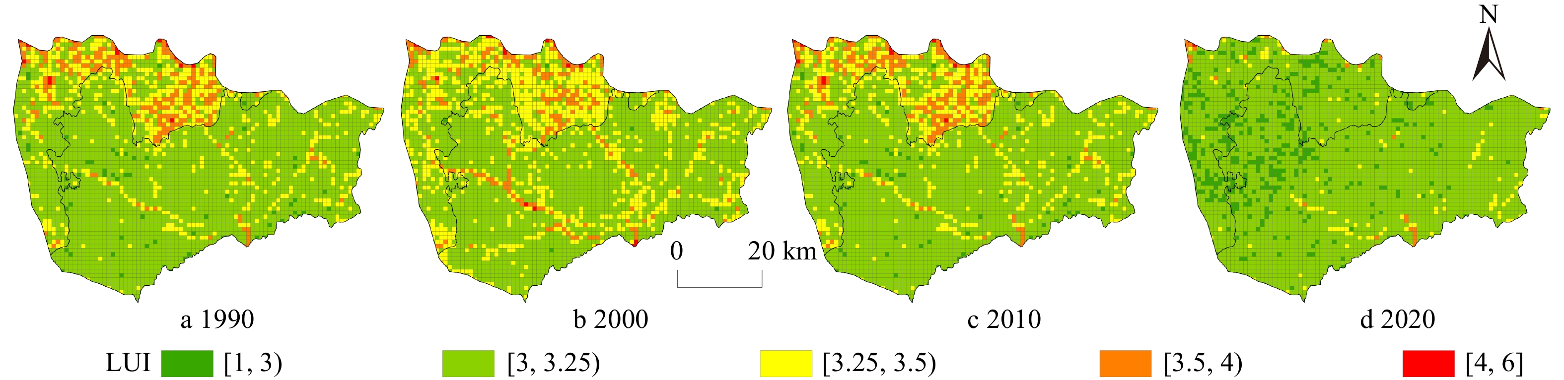
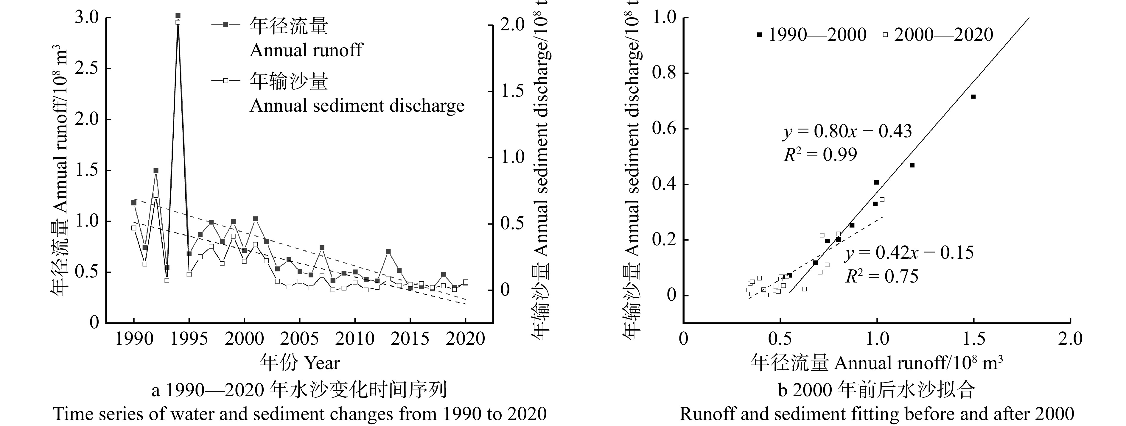
结果(1)2000年后北洛河上游农田向草地、森林转移,其面积减幅达79.05%,其中“农田→森林”集中分布于吴起县东南部,“农田→草地”在定边县分布最为密集。(2)2000—2020年流域FVC迅速增加,吴起县整体FVC高于定边县同期水平;定边县LUI变化较吴起县存在滞后性,但二者均在2010—2020年间明显下降。(3)2000年前后年径流、输沙减少率分别为46.68%、81.83%;2000—2020年来沙系数0.42小于1990—2000年来沙系数0.80。(4)FVC与水沙量呈显著负相关,森林AREA_MN、AI分别与径流量、输沙量呈显著正相关,森林LPI、LSI与径流量、森林LSI与输沙量呈显著负相关。
结论北洛河上游水沙与土地利用结构布局关系密切,不同县域地表覆被与用地强度差异明显,在退耕还林(草)驱动下该地区土地总体变化趋势有助于削减径流泥沙。研究结果将为流域土地利用与黄土高原径流泥沙关系研究提供参考。
Abstract:ObjectiveThe purpose of this study was to investigate the favorability of land use changes in identifying the causes of runoff and sediment variations, providing guiding significance for the implementation and improvement of watershed soil and water conservation and ecological protection policies.
MethodThe research selected the upper reaches of the Beiluo River as the study area and utilized the GEE and PIE-Engine platforms to acquire land use and fraction vegetation cover (FVC) data from 1990 to 2020. Descriptions of land use in various counties in the upper reaches of the Beiluo River were conducted from four aspects: land class transitions, FVC, land use intensity (LUI), and landscape pattern (average patch area, AREA_MN; largest patch index, LPI; landscape shape index, LSI; aggregation index, AI). Additionally, the correlation between land use and runoff-sediment was explored by integrating runoff and sediment data.
Result(1) After 2000, there was a shift from farmland to grassland and forests in the upper reaches of the Beiluo River, with a reduction in area by 79.05%. The transition from “farmland to forest” was concentrated in the southeast of Wuqi County, while “farmland to grassland” was most densely distributed in Dingbian County, Shaanxi Province of northwestern China. (2) From 2000 to 2020, the FVC in the basin increased rapidly, with Wuqi County having an overall higher FVC than Dingbian County. The change in land use intensity in Dingbian County lagged behind that of Wuqi County, but both exhibited a significant decreasing trend from 2010 to 2020. (3) Around 2000, the reduction rates of annual runoff and sediment transport were 46.68% and 81.83%, respectively. Coefficient of sediment inflow from 2000 to 2020 (0.42) was less than that from 1990 to 2000 (0.80). (4) Under the same runoff volume, sediment transport from 2000 to 2020 was much lower than that from 1990 to 2000. FVC showed a significant negative correlation with runoff-sediment, while forest AREA_MN and AI were significantly positively correlated with runoff. Forest LPI, LSI were significantly negatively correlated with runoff, and forest LSI was negatively correlated with sediment transport.
ConclusionThe runoff and sediment in the upper reaches of the Beiluo River are closely related to the structural layout of land use. Different counties exhibit significant differences in land cover and land use intensity. Under the driving force of returning farmland to forest (grassland), the overall trend of land in this region contributes to the reduction of runoff sediment. The research results will provide reference for the study of the relationship between watershed land use and runoff sediment on the Loess Plateau.
-
Keywords:
- the Beiluo River /
- land use intensity /
- vegetation coverage /
- landscape pattern /
- runoff sediment
-
-
![]()
图 2 1990—2020年土地利用时空变化
Figure 2. Temporal and spatial changes of land use from 1990 to 2020
![]()
图 3 2000—2020年土地利用转移空间分布
Figure 3. Spatial distribution of land use transfer from 2000 to 2020
![]()
图 4 1990—2020年植被覆盖度(FVC)空间分布
Figure 4. Spatial distribution of fraction vegetation cover (FVC) from 1990 to 2020
![]()
图 5 1990—2020年土地利用强度(LUI)空间分布
Figure 5. Spatial distribution of land use intensity (LUI) from 1990 to 2020
![]()
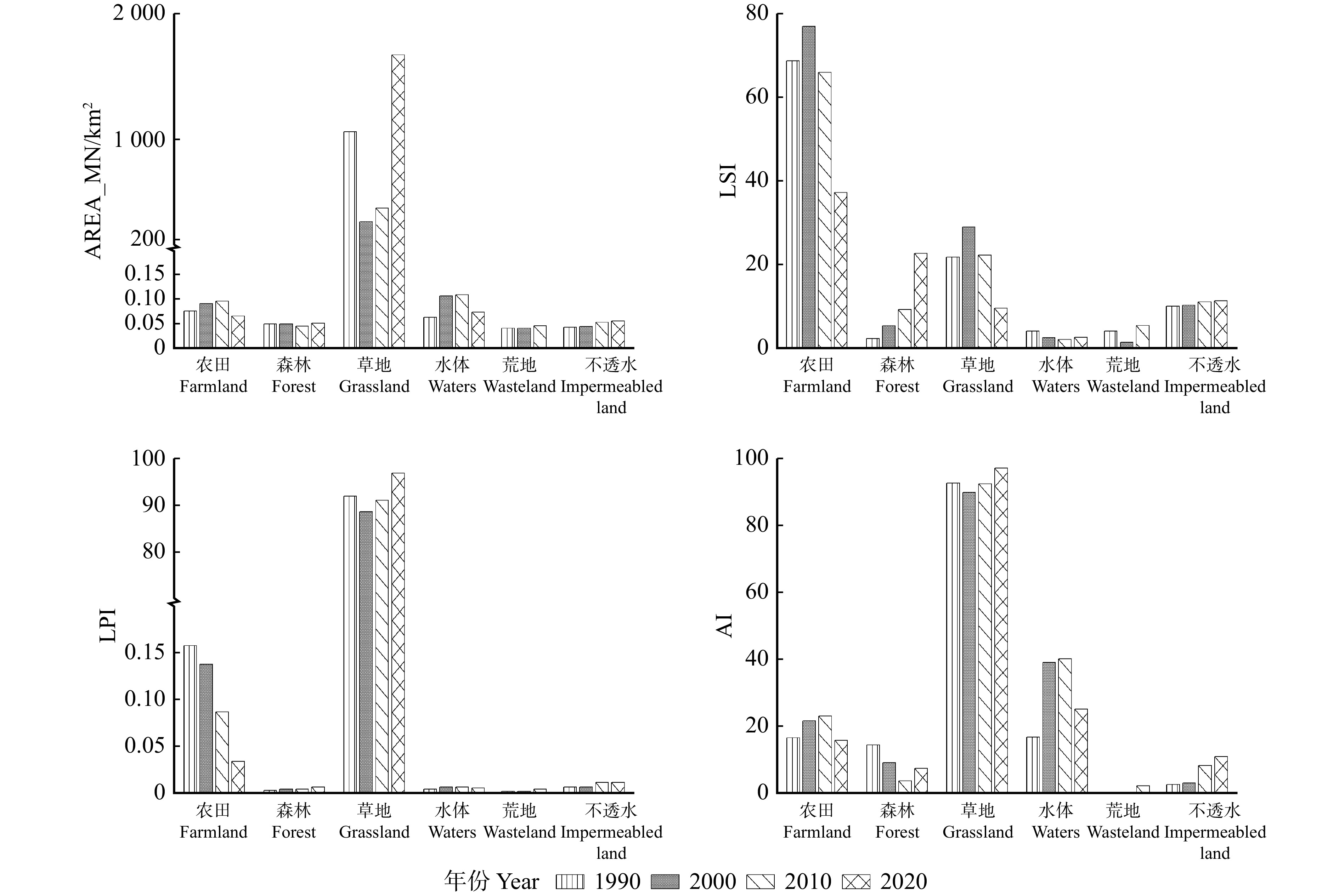
图 6 1990—2020年北洛河上游景观指数变化
Figure 6. Changes of landscape index in the upper reaches of the Beiluo River from 1990 to 2020
![]()
图 7 水沙变化时间序列及分段拟合
Figure 7. Time series and segmented fitting of runoff and sediment changes
表 1 土地强度分级
Table 1 Classification of land use intensity
项目 Item 不透水
Impermeable land农田
Farmland森林
Forest草地
Grassland水体
Waters荒地
Wasteland用地强度等级
Land use intensity level6 5 4 3 2 1  下载: 导出CSV
表 2 景观指数描述
Table 2 Landscape index description
景观指数
Landscape index生态学意义 Ecological significance 平均斑块面积
Average patch area (AREA_MN)反映景观结构,取值越小,景观破碎度程度越高
Reflecting the landscape structure, the smaller the value is, the higher the degree of landscape fragmentation is最大斑块指数
Max. patch index (LPI)最大斑块面积占总景观面积的百分比,反映人类干扰的强度和频率
This index is the percentage of the max. patch area to the total landscape area, reflecting the intensity and frequency of human disturbance景观形状指数
Landscape shape index (LSI)当景观形状为圆形或者正方形时,LSI = 1,当景观中斑块形状不规则或偏离正方形时,LSI值增大
When the landscape shape is circular or square, LSI = 1. When the patch shape in the landscape is irregular or deviates from the square, the LSI value increases聚合度指数
Aggregation index (AI)反映不同景观类型斑块之间的连通性,取值越小,景观越离散
Reflecting the connectivity between different landscape type patches, the smaller the value is, the more discrete the landscape is
下载: 导出CSV
表 3 1990—2020年土地利用年际统计特征
Table 3 Inter annual statistical characteristics of land use from 1990 to 2020
km2 土地利用类型
Land use type1990 2000 2010 2020 1990—2020 面积 Area 面积 Area 变化量 Variation 面积 Area 变化量 Variation 面积 Area 变化量 Variation 变化量 Variation 农田 Farmland 276.84 387.95 111.11 301.12 −86.83 81.29 −219.83 −195.55 森林 Forest 0.34 1.34 1.00 3.86 2.52 23.13 19.27 22.79 草地 Grassland 3 183.78 3 072.39 −111.39 3 155.61 83.22 3 354.50 198.89 170.72 水体 Waters 0.82 0.55 −0.27 0.37 −0.18 0.45 0.08 −0.37 荒地 Wasteland 0.77 0.10 −0.67 0.05 −0.05 1.27 1.22 0.50 不透水Impermeable land 4.71 4.93 0.22 6.25 1.32 6.62 0.37 1.91
下载: 导出CSV
表 4 水沙与FVC及部分景观参数Pearson相关分析
Table 4 Pearson correlation analysis of runoff and sediment, FVC, and some landscape parameters
项目 Item FVC 森林 Forest 不透水 Impermeable land LPI LSI AREA_MN AI LPI AREA_MN AI 年径流量 Annual runoff −0.422* −0.422* −0.492** 0.094 0.475** −0.543** −0.456** −0.477** 年输沙量 Annual sediment discharge −0.380* −0.330 −0.379* 0.119 0.431* −0.473** −0.358* −0.373* 注:*表示显著性水平P < 0.05,**表示显著性水平P < 0.01。Notes: * indicates a significant level of P < 0.05, ** indicates a significant level of P < 0.01.
下载: 导出CSV
-
[1] 张玉珊, 舒栋才, 李瑞, 等. 赤水河流域生态水文过程对土地利用/覆被变化的响应[J]. 土壤通报, 2022, 53(1): 56−65. Zhang Y S, Shu D C, Li R, et al. Responses of ecohydrological processes to land use/cover change in the Chishui River Basin[J]. Chinese Journal of Soil Science, 2022, 53(1): 56−65.
[2] 傅伯杰. 黄土高原土地利用变化的生态环境效应[J]. 科学通报, 2022, 32(67): 3768−3779. Fu B J. Ecological and environmental effects of land-use changes in the Loess Plateau of China[J]. Chinese Science Bulletin, 2022, 32(67): 3768−3779.
[3] 刘晓君, 李占斌, 李鹏, 等. 基于土地利用/覆被变化的流域景观格局与水沙响应关系研究[J]. 生态学报, 2016, 36(18): 5691−5700. Liu X J, Li Z B, Li P, et al. Land use/cover change based relationship between landscape, runoff, and sedimentation[J]. Acta Ecologica Sinica, 2016, 36(18): 5691−5700.
[4] 陈浩. 黄土高原退耕还林前后流域土壤侵蚀时空变化及驱动因素研究[D]. 杨凌: 西北农林科技大学, 2019. Chen H. Spatial and temporal changes of soil erosion and its driving factors before and after the “Grain for Green” project in the Loess Plateau[D]. Yangling: Northwest A&F University, 2019.
[5] 马耘秀, 夏露, 范毅,等. 土地利用和气候变化对黄土区典型流域水沙变化的影响[J]. 水土保持学报, 2021, 35(2): 38−46. Ma Y X, Xia L, Fan Y, et al. The impact of land use and climate change on water and sediment changes in typical watersheds in the Loess Plateau[J]. Journal of Soil and Water Conservation, 2021, 35(2): 38−46.
[6] Wang H, Zhang G, Liu F, et al. Effects of biological crust coverage on soil hydraulic properties for the Loess Plateau of China[J]. Hydrological Processes, 2017, 31(19): 3396−3406. doi: 10.1002/hyp.11263
[7] Xiao B, Sun F, Hu K, et al. Biocrusts reduce surface soil infiltrability and impede soil water infiltration under tension and ponding conditions in dryland ecosystem[J]. Journal of Hydrology, 2019, 568: 792−802. doi: 10.1016/j.jhydrol.2018.11.051
[8] 张攀, 姚文艺, 刘国彬, 等. 土壤复合侵蚀研究进展与展望[J]. 农业工程学报, 2019, 35(24): 154−161. Zhang P, Yao W Y, Liu G B, et al. Research progress and prospects of complex soil erosion[J]. Transactions of the Chinese Society of Agricultural Engineering, 2019, 35(24): 154−161.
[9] 谢剑, 高鹏, 穆兴民, 等. 近80年来北洛河流域径流变化特征及其归因分析[J]. 水土保持研究, 2023, 30(2): 122−128. Xie J, Gao P, Mu X M, et al. Variation characteristics of runoff in Beiluo river basin over the past 80 years and its attribution analysis[J]. Soil and Water Conservation Research, 2023, 30(2): 122−128.
[10] 薛帆, 晁智龙, 何亮, 等. 近70年来不同地貌和植被类型区水沙特征演变及其对生态恢复的响应[J]. 生态学报, 2023, 43(8): 3247−3260. Xue F, Chao Z L, He L, et al. Hydrologic and sediment responses to ecological restoration in different geomorphological and vegetation type areas in past 70 years[J]. Acta Ecologica Sinica, 2023, 43(8): 3247−3260.
[11] 谢敏, 张晓明, 赵阳, 等. 北洛河流域水沙变化对降雨和土地利用的响应[J]. 中国水利水电科学研究院学报, 2019, 17(1): 39−44. Xie M, Zhang X M, Zhao Y, et al. Response of water and sediment changes in the Beiluo River Basin to rainfall and land use[J]. Journal of China Institute of Water Resources and Hydropower Research, 2019, 17(1): 39−44.
[12] Yang J , Huang X. The 30 m annual land cover dataset and its dynamics in China from 1990 to 2019[J]. Earth System Science Data, 2021, 13(8): 3907−3925.
[13] 李峰平. 变化环境下松花江流域水文与水资源响应研究[D]. 北京: 中国科学院研究生院, 2015. Li F P. Study on water cycle and water resources in Songhua River Basin under the changing environment[D]. Beijing: Graduate School of Chinese Academy of Sciences, 2015.
[14] 曾志伟, 杨华, 宁启蒙,等. 洞庭湖区土地利用强度演变及其对生态系统服务的影响[J]. 经济地理, 2022, 42(9): 176−185. Zeng Z W, Yang H, Ning Q M, et al. Evolution of land use intensity in Dongting Lake area and its impact on ecosystem services[J]. Economic Geography, 2022, 42(9): 176−185.
[15] 庄大方, 刘纪远. 中国土地利用程度的区域分异模型研究[J]. 自然资源学报, 1997, 12(2): 10−16. doi: 10.11849/zrzyxb.1997.02.002 Zhuang D F, Liu J Y. Research on regional differentiation model of land use degree in China[J]. Journal of Natural Resources, 1997, 12(2): 10−16. doi: 10.11849/zrzyxb.1997.02.002
[16] 冯新惠, 李艳, 余迩, 等. 长三角城市群碳排放绩效与土地利用强度时空格局及协调发展特征[J]. 农业工程学报, 2023, 39(3): 208−218. Feng X H, Li Y, Yu E, et al. Spatiotemporal pattern and coordinating development characteristics of carbon emission performance and land use intensity in the Yangtze River Delta urban agglomeration[J]. Transactions of the Chinese Society of Agricultural Engineering, 2023, 39(3): 208−218.
[17] 许文旭, 毕华兴, 王亚娟. 晋西黄土区流域景观格局对径流及其组分的影响[J]. 北京林业大学学报, 2023, 45(10): 118−126. doi: 10.12171/j.1000-1522.20230037 Xu W X, Bi H X, Wang Y J. Effects of watershed landscape pattern on runoff and its components in the loess region of western Shanxi Province, northern China[J]. Journal of Beijing Forestry University, 2023, 45(10): 118−126. doi: 10.12171/j.1000-1522.20230037
[18] 易阿岚, 王钧. 上海市湿地景观格局时空演变与驱动机制的量化研究[J]. 生态学报, 2021, 41(7): 2622−2631. Yi A L, Wang J. Quantitative study on spatio-temporal evolution and mechanisms of wetland landscape patterns in Shanghai[J]. Acta Ecologica Sinica, 2021, 41(7): 2622−2631.
[19] 吴健生, 易腾云, 王晗. 2000—2030年深港景观格局演变时空分异与趋势对比分析[J]. 生态学报, 2021, 41(22): 8718−8731. Wu J S, Yi T Y, Wang H. Compare live analysis of spatial and temporal variation and trend of landscape partem evolution between Shenzhen and Hongkong from 2000 to 2030[J]. Acta Ecologica Sinica, 2021, 41(22): 8718−8731.
[20] 李明珍, 李阳兵, 冉彩虹. 土地利用转型背景下的乡村景观格局演变响应: 基于草堂溪流域的样带分析[J]. 自然资源学报, 2020, 35(9): 2283−2298. doi: 10.31497/zrzyxb.20200919 Li M Z, Li Y B, Ran C H. Evolution of rural landscape pattern under the background of land use transformation: based on the transect analysis of Caotangxi Watershed[J]. Journal of Natural Resources, 2020, 35(9): 2283−2298. doi: 10.31497/zrzyxb.20200919
[21] 宋午椰, 许行, 林毅雁, 等. 黄土高原植被净初级生产力时空变化特征及驱动因子分析[J]. 北京林业大学学报, 2023, 45(8): 29−42. Song W Y, Xu H, Lin Y Y, et al. Spatial and temporal variation and driving forces for the net primary productivity of vegetation on the Loess Plateau[J]. Journal of Beijing Forestry University, 2023, 45(8): 29−42.
[22] 邹亚东, 何亮, 张晓萍, 等. 基于GEE数据平台的北洛河流域1970—2019年土地利用结构变化特征[J]. 水土保持通报, 2021, 41(6): 209−219. Zou Y D, He L, Zhang X P, et al. Characteristics of land use structure change in Beiluo River basin during 1970−2019 based on Google Earth Engine[J]. Bulletin of Soil and Water Conservation, 2021, 41(6): 209−219.
[23] 王祯, 吴金华, 白帅, 等. 黄土丘陵沟壑区耕地细碎化评价与土地整治工程分区: 以吴起县为例[J]. 水土保持研究, 2022, 29(4): 300−307. Wang Z, Wu J H, Bai S, et al. Evaluation of cultivated land fragmentation and land consolidation engineering zoning in the loess hilly and gully region: a case study in Wuqi County[J]. Soil and Water Conservation Research, 2022, 29(4): 300−307.
[24] 周毅. 陕西吴起县退耕地植被恢复及生态效益研究[D]. 北京: 北京林业大学, 2012. Zhou Y. Research on vegetation restoration and ecological benefits of returned farmland in Wuqi County, Shaanxi Province[D]. Beijing: Beijing Forestry University, 2012.
[25] 刘强, 尉飞鸿, 常康飞, 等. 黄河中游龙潼区间水沙变化特征及其对降水和人类活动的响应[J]. 应用基础与工程科学学报, 2023, 31(3): 555−568. Liu Q, Wei F H, Chang K F, et al. Characteristics of water and sediment changes in the Longtong section of the middle reaches of the Yellow River and their response to precipitation and human activities[J]. Journal of Applied Fundamentals and Engineering Science, 2023, 31(3): 555−568.
[26] 罗佳茹, 李斌斌, 张风宝, 等. 黄丘区特色治理开发小流域土壤侵蚀变化对景观格局演变的响应[J]. 应用生态学报, 2021, 32(12): 4165−4176. Luo J R. Li B B, Zhang F B, et al. Responses of goll eroslon to changes in landecape paltern and its evolution in watershed in the loess hilly region under characteristic management and development[J]. Chinese Journal of Applied Ecology, 2021, 32(12): 4165−4176.
-
期刊类型引用(2)
1. 苏岫,王祥,宋德瑞,李飞,杨正先,张浩. 基于改进光谱角法的红树林高分遥感分类方法研究. 海洋环境科学. 2021(04): 639-646 .  百度学术
百度学术
2. 陈冀岱,牛树奎. 多时相高分辨率遥感影像的森林可燃物分类和变化分析. 北京林业大学学报. 2018(12): 38-48 . 本站查看
其他类型引用(3)


计量
- 文章访问数: 430
- HTML全文浏览量: 116
- PDF下载量: 41
- 被引次数: 5
