
Effects of rain flood control about low impact development system in West 10 Plot of Shougang based on the SWMM simulation
-
摘要:目的根据《新首钢高端产业综合服务区控制性详细规划》要求,首钢西十项目以消纳北京市3年一遇24 h降雨量(108 mm)为目标进行低影响开发系统设计,从雨水渗透滞留与储存利用两个角度考虑,以西十地块的现状特征为依据制定相应的设计策略。方法针对渗透滞留系统,通过SWMM建立低影响开发模型和传统开发模型,模拟不同重现期(1年一遇、2年一遇、3年一遇、5年一遇、10年一遇、20年一遇)24 h降雨条件下的径流排放过程,对比分析两种开发模式的径流总量、峰值流量和峰现时间;针对储蓄利用系统,通过SWMM模拟2017年全年降雨过程,以周为单位统计外源雨水调蓄池收集的径流总量,与西十地块植物灌溉需水量相比较,分析雨水调蓄池中收集径流的利用情况。结果(1) 依据场地现状在其内部设计绿色屋顶、透水铺装、下凹绿地、植草沟、生物滞留池、雨水调蓄池6种LID设施,在1年一遇、2年一遇、3年一遇、5年一遇、10年一遇、20年一遇的降雨条件下,西十地块低影响开发系统对径流总量的削减率为100%、100%、100%、78.79%、50.41%、34.73%;对峰值流量的削减率为100%、100%、100%、70.12%、33.33%、19.44%,1~3年重现期峰值消失,其后峰值出现时间推迟375、310、240 min。(2)2017年,外源雨水地块雨水调蓄池接纳径流总量9 617 m3,径流收集主要集中在第25~35周,单周最大收水总量为2 078 m3,发生在第27周(6月初),第1~20周、43~52周收水量基本为0;2017年第25周、第27周、第29~32周、第34~35周、第41周雨水调蓄池收集径流量在满足本周灌溉需求后仍有余量,冬季雨水调蓄池空置率较大。结论(1) 低影响开发设施对雨洪问题具有良好的调控效果,可以减少径流总量、峰值流量和推迟峰现时间,但随着时间的推迟削减能力逐渐减弱。低影响开发系统的雨洪调控能力具有上限。(2)根据北京市2017年全年降雨量日值统计,外源雨水地块雨水调蓄池中径流收集的利用率为43.65%,有30周(210 d)雨水调蓄池空置率为100%,较为浪费。在进行低影响开发系统设计时,应综合考虑成本造价等因素。Abstract:ObjectiveAccording to the requirements of New Shougang High-End Industry Comprehensive Service Area Control Detailed Planning, West 10 Project carries out rainwater system with the goal of eliminating Beijing's 3-year return period of 24 hours rainfall (108 mm). This study corresponds rainwater system design strategy according to the current characteristics, which concludes rainwater infiltration-retention system and storage-utilization system.MethodFor the infiltration-retention system, two development models of low impact development and traditional development were established through SWMM, simulating rainwater runoff discharge under 24 hours rainfall in different return periods (1, 2, 3, 5, 10 and 20 years) to analyze the regulative effect of two development models in total runoff, peak flow as well as time of peak flow appearance. For the storage-utilization system, simulating the annual rainfall process in 2017 through SWMM and counting the total amount of rainwater collected by the rain retention barrel on a weekly basis, which was compared with the irrigation water demand of the West 10 Plot was to analyze the utilization of rainwater collected in the rain retention barrel.Result(1) According to the current situation of the site, West 10 Plot had been designed six LID facilities, which was green roof, permeable pavement, rain garden, vegetative swale, bio-retention cell and rain retention barrel. In the return periods from 1 to 20 years, the reduction rate of the runoff volume of the low-impact development system in West 10 Plot was 100%, 100%, 100%, 78.79%, 50.41%, 34.73%, and the reduction rate of the peak flow was 100%, 100%, 100%, 70.12%, 33.33%, 19.44%. The peak value disappeared in the 1-3 year return periods, and the time of peak flow appearance was delayed by 375, 310 and 240 min. (2) The rain retention barrel of exogenous rainwater area stored 9 617 m3 rainfall for the whole year of 2017. The rainwater collection was mainly concentrated in the 25th to 35th week. The maximum water collection per week was 2 078 m3, which occurred in the 27th week (at the beginning of June), the water collection in the first to 20th week and the 43th to 52nd week was basically zero. In week 25, 27, 29-32, 34-35 and 41 of 2017, the amount of water collected in the rain retention barrels was still sufficient after meeting the irrigation demand of the West 10 Plot, and the vacancy rate of the rainwater storage barrels in winter was relatively high.Conclusion(1) LID facilities had a good control effect on rain-flood problems, which can reduce the total runoff, peak flow and delay the peak time. However, with the delay of time, the capacity of LID was gradually weakened, so it can be seen that the rain-flood control capacity of low-impact development systems had an upper limit. (2)According to the statistics of the annual rainfall daily value of 2017 in Beijing, the utilization rate of runoff collection in the rain retention barrel of the exogenous rainwater area was 43.65%, and the vacancy rate of the rain retention barrel in 30 weeks (210 days) was 100%, which was relatively wasteful. Therefore, the cost and other factors should be taken into account in the low-impact development system design.
-
在快速城镇化发展进程中,人类较大程度地改变了自然地形地貌,以不透水地面铺砌代替原有透水土壤和植被,造成下渗量与蒸发量的显著减少,从而引起同强度暴雨形成的地表径流量增大,峰值流量增加等现象[1]。为解决城市内涝等问题,“海绵城市”和低影响开发系统(Low impact development, LID)概念应运而生。目前对低影响开发系统的研究多数集中于市政道路[2]、住宅小区[3-4]、公园绿地[5-6]以及城市绿道[7]中绿地的渗透滞留能力,对其后续储蓄利用的量化研究较少。为解决上述问题,本文以位于北京市的首钢西十为研究对象,结合景观需求建设渗透滞留与储蓄利用相结合的低影响开发系统。
1. 研究区域概况
北京市位于华北平原北部,为典型的北温带半湿润大陆性季风气候,年平均降雨量(1950—2012年期间)为585.0 mm,80%降雨量集中于汛期(6—9月)[8],对城市内涝造成极大压力。本文选取首钢北区西北角的西十片区作为研究区域,西十内部及周边场地硬质化程度高达65.3%,现状下垫面对自然雨水下渗疏解能力非常有限,具有典型特征。
西十地块原为首钢料场,运输线两侧土壤含铁较高,研究表明土壤污染深度为0.5~2.0 m[15]。改造过程中将表层以下2 m的土壤替换为壤土,渗透系数为3.5×10⁻⁶ m/s[9]。
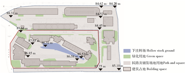
如图 1、图 2所示,西十地块四面环街,占地4.24 hm2,地势整体呈西北高东南低,内部有筒仓、转运站、料仓、泵站等多组建筑体,总占地面积约1.5 hm2。场地周边区域(包括秀池东路、秀池北街两条道路和筒仓办公楼、北七筒建筑遗址、停车场、N3-17办公楼、武警用房、员工宿舍、干法除尘等建筑及其外环境,共5.8 hm2)地势略低于西十地块,东侧和北侧有多组由厂房改建的配套服务建筑,强降雨时存在较为严重的内涝问题亟待解决,因此将其与西十地块一同作为本文的研究对象,称为外源雨水地块。
2. 低影响开发系统空间布局设计
2.1 设计目标与原则
根据《新首钢高端产业综合服务区控制性详细规划》要求,西十地块及外源雨水地块低影响开发系统雨水消纳能力应达到北京市3年一遇24 h降雨量(108 mm[9])的标准。设计在满足功能需求和景观效果的前提下,制定合理的低影响开发系统设计策略,在有限的绿地空间中因地制宜地叠加低影响开发设施层以应对降雨后地表径流产生速度加快、峰值流量加大、峰现时间提前等问题,以达到上位规划对径流消纳的要求,同时考虑将收集的地表径流用于后期灌溉。
2.2 设计策略
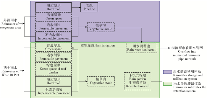
根据《海绵城市建设技术指南》低影响开发主要通过“源头削减、中途传输、末端调蓄”等多种手段[10]。西十地块及外源雨水场地提出的设计策略为:根据场地竖向、土地利用等条件优先构建渗透滞留系统,在不具备条件的情况下考虑将径流收集再利用,从源头、中途、末端3个方面进行低影响开发系统设计(见图 3)。
2.2.1 西十地块低影响开发系统
西十地块以建立渗透滞留系统为目标,针对“源头削减”本研究提出在满足功能使用的前提下,尽可能多地利用透水铺装、建设绿色屋顶、增加绿地面积,从源头有效削减地表径流。此次设计的“中途传输”途径为植草沟,沿硬质边缘形成线性景观带,达到收集、传输、滞留及下渗径流的目的。“末端调蓄”设施有下沉式绿地、生物滞留池两种。植草沟内的雨水排入末端调蓄设施内,雨水在此进行滞留下渗,当雨量过大时末端调蓄设施内的雨水通过溢流口排入市政雨水管网。
2.2.2 外源雨水地块低影响开发系统
外源雨水地块绿地面积较小(占总面积的28.3%),不适宜做渗透滞留设施,且建筑密度较大、人群活动量大,雨水应尽快排出场地,因此将建立储存利用系统作为设计策略。“末端调蓄”设施只有雨水调蓄池,调蓄池内收集的雨水用于西十地块浇灌。
2.3 设计内容
综上所述,西十地块及外源雨水地块低影响开发系统分为渗透滞留和储蓄利用两部部分。渗透滞留系统包含种植屋面、透水铺装、下凹式绿地、植草沟、生物滞留池5类LID设施;储蓄利用系统以雨水调蓄池为储蓄设施收集地表径流。低影响系统设计见图 4,各类LID设施设计要点见表 1,各类用地面积及用地比例见表 2和表 3。
表 1 各类LID设施设计要点Table 1. Design points of LID facilities区域Area 低影响开发设施LID facility 设计要点Design point 西十地块West 10 Plot 种植屋面Planting roof 将具备条件的平屋顶(6 495.1 m2)改建为可上人的屋顶花园,为办公人员提供多样活动空间的同时,在急降雨时可滞存一部分雨水以达到推迟峰现时间的目的The flat roof (6 495.1 m2) which can be converted into a roof garden provides office workers with a variety of activity spaces and retains rainwater in case of emergency rainfall to delay the peak time 透水铺装Permeable pavement 将场地中工业废弃物加工成透水混凝土砖,应用于地块内主园路(6 647.8 m2)Permeable concrete bricks which are processed from industrial wastes in the site applied to the main garden road (6 647.8 m2) in the plot 植草沟Vegetative swale 沿硬质边缘形成线性景观带(425.4 m2),以接纳铺装及绿地上的地表径流,将径流输送至雨水花园内部A linear landscape belt (425.4 m2) is formed along the hard edge to accept the surface runoff from pavement and green space and transport the runoff to the rain garden 下凹式绿地Rain garden 选择地块内部地势较低的区域集中布置两处下凹绿地(1 090.5 m2),一处位于建筑下沉庭院内,可就近接纳周边绿地及铺装上的地表径流;另一处利用下洼料场基址设计成90余米长的带状雨水花园,其为地表终端LID设施,接纳场地内全部径流Two concave green spaces (1 090.5 m2) are arranged centrally in the low-lying area inside the plot. One is located in the sunken courtyard of the building, which can receive the runoff of surrounding green space and pavement. Another site is designed as a belt rain garden more than 90 m long, which is the surface terminal LID facility and accepts all runoff in the site 生物滞留池Bio-retention cell 在人群活动量相对较小的地势低洼区域布置了1 035.8 m2的生物滞留池,当强降雨发生后,生物滞留池中一定时间内的雨水积蓄不影响场地的正常使用In low-lying areas with relatively small amount of population activity, 1 035.8 m2 of bio-retention cell was arranged. When heavy rainfall occurred, rainwater accumulation in the bio-retention cell within a certain period of time did not affect the normal use of the site 外源雨水地块Exogenous rainwater area 透水铺装Permeable pavement 将场地中工业废弃物加工成透水混凝土砖,应用于秀池北街、秀池东路人行道(7 422.0 m2)Permeable concrete bricks which are processed from industrial wastes in the site applied to the sidewalks of Xiuchi North Street and Xiuchi East Road (7 422.0 m2) 植草沟Vegetative swale 沿硬质边缘形成线性景观带(443.1 m2),以接纳铺装及绿地上的地表径流,将径流输送至雨水调蓄池中A linear landscape belt (443.1 m2) is formed along the hard edge to accept the surface runoff from pavement and green space and transport the runoff to the rain retention barrel 雨水调蓄池Rain retention barrel 外源雨水场地低处设置有雨水调蓄池,以接纳建筑屋顶雨水及全部地表径流。以设计目标为根据进行计算,外源雨水地块雨水调蓄池总容量为4 189 m3,方可达到消纳北京市3年重现期24 h降雨量这一目标。雨水调蓄池内雨水用于西十地块植物灌溉,并设有溢水口,当降雨强度超过地块内部LID设施消纳能力时,雨水通过溢水口排入市政雨水管网A rain retention barrel is installed at the lower level of the exogenous rainwater area to receive rainwater from the roof of the building and all surface runoff. According to the calculation based on the design objective, the total capacity of rain retention barrel in the exogenous rainwater area was 4 189 m3, which can reach the goal of absorbing 24-hour rainfall in the 3-year recurrence period of Beijing. Rainwater in the rain retention barrel is used for plant irrigation in the west 10 plot, and there is an overflow outlet. When the rainfall intensity exceeds the capacity of LID facilities inside the block, rainwater was discharged into the municipal rainwater pipe network through the overflow outlet 表 2 西十地块用地面积及用地比例表Table 2. Table of West 10 Plot of land area and land use ratio用地类型Type of land use 项目类型Item type 面积Area/m2 总面积Total area/m2 子项比例Subitem proportion/% 比例Proportion/% 绿化用地Green space 普通绿地Common green space 15 737.9 18 371.8 37.1 43.4 植草沟Vegetative swale 425.4 1.1 生物滞留池Bio-retention cell 1 035.8 2.4 下沉式绿地Rain garden 1 172.7 2.8 建筑占地Building space 屋顶花园绿地Green space of roof garden 4 871.3 14 987.3 11.5 35.7 屋顶花园铺装Impermeable pavement of roof garden 1 623.8 3.8 不上人硬质屋顶Hard roof of no people 8 492.2 20.4 园路及铺装场地用地Path and square 透水铺装Permeable pavement 6 647.8 8 954.4 15.6 20.8 不透水铺装Impermeable pavement 2 306.6 5.2 水体Water space 景观水体(不具备调蓄功能) Landscape water space (no regulating function) 52.3 52.3 0.1 0.1 合计Total 42 365.8 100 表 3 外源雨水地块用地面积及用地比例表Table 3. Table of exogenous site of land area and land use ratio用地类型Type of land use 项目类型Item type 面积Area/m2 总面积Total area/m2 子项比例Subitem proportion/% 比例Proportion/% 绿化用地Green space 普通绿地Common green space 15 967.6 16 410.7 27.5 28.3 植草沟Vegetative swale 443.1 0.8 建筑占地Building space 不上人硬质屋顶Hard roof of no people 16 865.1 16 865.1 29.1 29.1 园路及铺装场地用地Path and square 透水铺装Permeable pavement 7 422.0 24 740.1 12.8 42.6 不透水铺装Impermeable pavement 17 318.1 29.8 雨水调蓄池(地下) Rain retention barrel 雨水调蓄池(地下) Rain retention barrel (underground) 4 189 4 189 合计Total 58 015.9 100 3. 研究方法
按照《新首钢高端产业综合服务区控制性详细规划》要求完成西十地块及外源雨水地块低影响开发系统设计,并对上述设计方案进行SWMM模型构建。构建西十地块与外源雨水地块两套体系,西十地块体系用于对比传统模型和低影响开发模型,以分析低影响开发系统的雨洪调控效果;外源雨水地块体系用于对比雨水调蓄池蓄水量与植物灌溉需水量,以分析两者之间的数量关系。
3.1 渗透滞留系统模型建立
通过SWMM构建低影响开发模型和传统开发模型,对比两者之间数据以分析首钢西十低影响开发系统对区域径流总量、峰值流量和峰现时间的调控效果。
3.1.1 低影响开发模型构建
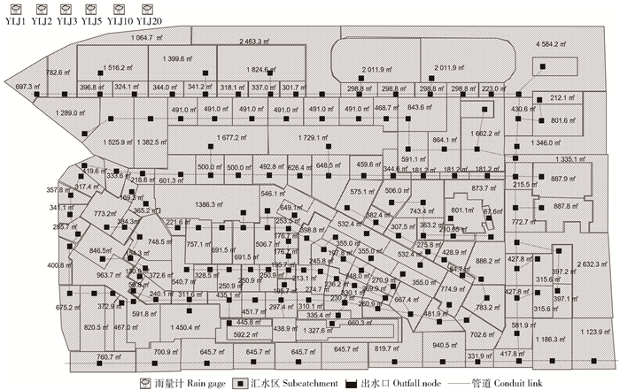
研究区域为西十地块及外源雨水地块,主要包含3类下垫面——屋顶、铺装、绿地。其中:不透水下垫面有硬质屋顶、不透水铺装;透水下垫面有绿色屋顶、透水铺装、绿地。根据上述低影响开发系统设计策略,遵循概化原则,将西十地块及外源雨水地块共划分为21个子汇水单元,末端出水口为2个。
3.1.2 传统开发模型构建
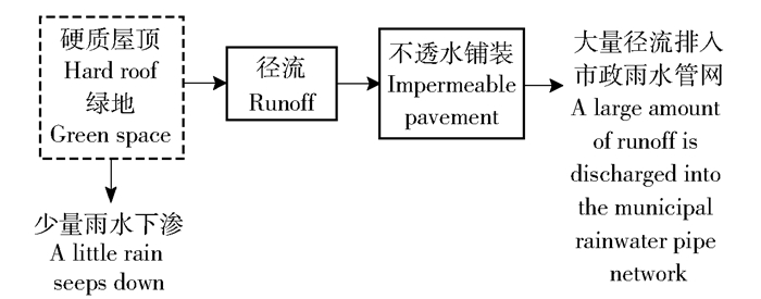
传统开发模式为通过竖向设计将绿地及屋顶径流排到铺装或道路上,再通过雨排水管线排入市政管网(图 5)。为方便后期对比分析,传统开发模型构建时绿地及铺装面积与低影响开发模型中一致(表 4)。雨排水管线图见图 6,SWMM模型概化图见图 7。
![]() 图 6 首钢西十传统雨水系统平面图Figure 6. Plan of traditional storm-water system in Shougang West 10 Plot
图 6 首钢西十传统雨水系统平面图Figure 6. Plan of traditional storm-water system in Shougang West 10 Plot![]() 图 7 首钢西十传统雨水系统概化图Figure 7. Generalized map of traditional storm-water system in Shougang West 10 Plot表 4 传统开发模式用地面积及用地比例表Table 4. Table of land area and land use ratio in traditional development model
图 7 首钢西十传统雨水系统概化图Figure 7. Generalized map of traditional storm-water system in Shougang West 10 Plot表 4 传统开发模式用地面积及用地比例表Table 4. Table of land area and land use ratio in traditional development model项目类型Item type 面积Area/m2 比例Proportion/% 绿化用地Green space 34 782.5 34.7 建筑占地Building space 31 852.4 31.7 园路及铺装场地用地Path and square 33 694.5 33.5 水体Water space 52.3 0.1 雨水调蓄池(地下) Rain retention barrel (underground) 4 189 合计Total 100 381.7 100 3.1.3 模块参数设置
本研究在推求各子汇水区的产流过程时,选用霍顿(Horton)公式进行下渗计算。根据方案设计对不同下垫面进行设定,各项参数参考SWMM用户手册[12]中的推荐值及相关文献。汇水模型为非线性水库模型,水力模型选用动力波模型[11]。根据场地土壤特性,入渗率为12.6 mm/h,衰弱常数为4 h-1。透水和不透水地表糙率系数分别为0.15和0.011,洼蓄量均为3 mm;植草沟宽度为2 000 mm,深度为500 mm;下沉式绿地平均深度为800 mm;生物滞留池平均深度为1 000 mm。
3.2 储蓄利用系统模型建立
根据北京市2017年全年降雨量日值统计(http://www.meteoblue.com/en/weather/archive/export/beijing-capital-international-airport_china_6301354),通过SWMM模拟得出西十地块及外源雨水场地每日径流总量及峰值流量;整合数据得到每周雨水调蓄池内收集的径流总量,同计算得出的浇灌需水量进行对比,以周为单位分析外源雨水地块收集的径流与西十地块的浇灌需求之间的关系。
4. 结果与分析
4.1 渗透滞留系统结果与分析
4.1.1 设计降雨选择
SWMM模型可使用的降雨数据为两种类型:(1)实测历时降雨资料;(2)设计降雨[13]。本研究根据北京《雨水控制与利用工程设计规范》(DB11/685—2013)北京地区1年一遇、2年一遇、3年一遇、5年一遇、10年一遇、20年一遇重现期降雨量分别为45、81、108、141、209、270 mm,降雨历时为24 h,模拟时间48 h。
4.1.2 结果与分析
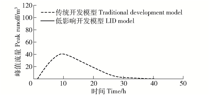
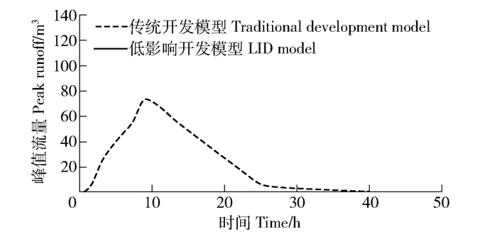
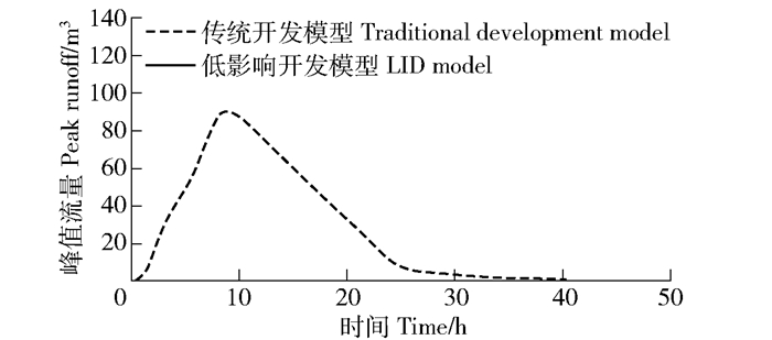
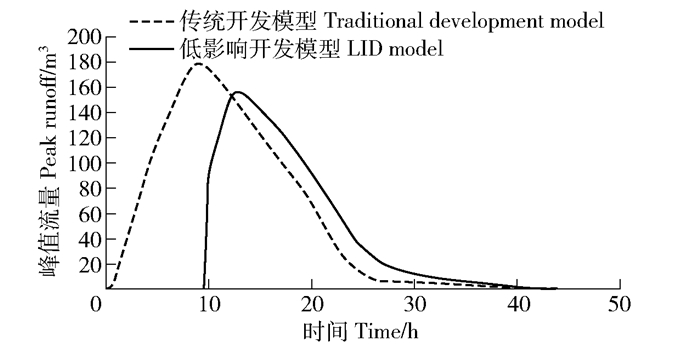
渗透滞留系统在重现期为1、2、3、5、10、20年的24 h降雨情况下,西十地块和外源雨水地块的低影响开发模型与传统开发模型的径流总量、峰值径流量和峰现时间分别见表 5和表 6;西十地块出口径流曲线对比图见图 8~13;外源雨水地块雨水调蓄池内部容积变化曲线对比图见图 14~19。根据上述数据结构可得出以下结果:
表 5 西十地块不同降雨强度下的出水口径流量模拟结果Table 5. Simulated results of West 10 Plot of the runoff under different rainfall intensities模拟项目Simulation item 1年一遇(45 mm)24 h 1-year-once(45 mm)24 hour 2年一遇(81 mm)24 h 2-year-once(81 mm)24 hour 3年一遇(108mm)24 h 3-year-once(108 mm)24 hour 5年一遇(141 mm)24 h 5-year-once(141 mm)24 hour 10年一遇(209 mm)24 h 10-year-once(209 mm)24 hour 20年一遇(270 mm)24 h 20-year-once(270 mm)24 hour 低影响开发模式LID model 传统开发模式Traditional development model 差值Difference 低影响开发模式LID model 传统开发模式Traditional development model 差值Difference 低影响开发模式LID model 传统开发模式Traditional development model 差值Difference 低影响开发模式LID model 传统开发模式Traditional development model 差值Difference 低影响开发模式LID model 传统开发模式Traditional development model 差值Difference 低影响开发模式LID model 传统开发模式Traditional development model 差值Difference 径流总量Total runoff/m3 0 1 189 1 189 0 2 411 2 411 0 3 490 3 490 1 028 4 846 3 818 3 818 7 699 3 881 6 712 10 284 3 572 峰值流量Peak flow/(m3·s-1) 0 0.027 0.027 0 0.065 0.065 0 0.092 0.092 0.037 0.124 0.087 0.128 0.192 0.064 0.203 0.252 0.049 峰现时间Time of peak flow occurrence 消失Disappea- rance 09:01 消失Disappea- rance 09:00 消失Disappea- rance 09:00 15:15 09:00 375 min 14:10 09:00 310 min 13:00 09:00 240 min 表 6 外源雨水地块不同降雨强度下的出水口径流量模拟结果Table 6. Simulated results of exogenous site of the runoff under different rainfall intensities模拟项目Simulation item 1年一遇(45 mm)24 h 1-year-once(45 mm)24 hour 2年一遇(81 mm)24 h 2-year-once(81 mm)24 hour 3年一遇(108 mm)24 h 3-year-once(108 mm)24 hour 5年一遇(141 mm)24 h 5-year-once(141 mm)24 hour 10年一遇(209 mm)24 h 10-year-once(209 mm)24 hour 20年一遇(270 mm)24 h 20-year-once(270 mm)24 hour 低影响开发模式LID model 传统开发模式Traditional development model 差值Difference 低影响开发模式LID model 传统开发模式Traditional development model 差值Difference 低影响开发模式LID model 传统开发模式Traditional development model 差值Difference 低影响开发模式LID model 传统开发模式Traditional development model 差值Difference 低影响开发模式LID model 传统开发模式Traditional development model 差值Difference 低影响开发模式LID model 传统开发模式Traditional development model 差值Difference 径流总量Total runoff/m3 800 1 806 1 006 2 633 3 599 966 4 189 5 156 967 6 145 7 108 963 10 249 11 205 956 13 970 14 912 942 峰值流量Peak flow/(m3·s-1) 0.026 0.040 0.014 0.079 0.093 0.014 0.116 0.132 0.016 0.162 0.179 0.017 0.256 0.275 0.019 0.341 0.362 0.021 峰现时间Time of peak flow occurrence 12:20 09:01 119 min 10:45 09:00 105 min 10:15 09:00 75 min 10:10 09:00 70 min 10:00 09:00 60 min 09:55 08:58 57 min ![]() 图 8 西十地块1年一遇24小时降雨出口径流曲线Figure 8. Runoff curve of 1-year-once 24 hour rainfall event in West 10 Plot
图 8 西十地块1年一遇24小时降雨出口径流曲线Figure 8. Runoff curve of 1-year-once 24 hour rainfall event in West 10 Plot![]() 图 9 西十地块2年一遇24小时降雨出口径流曲线Figure 9. Runoff curve of 2-year-once 24 hour rainfall event in West 10 Plot
图 9 西十地块2年一遇24小时降雨出口径流曲线Figure 9. Runoff curve of 2-year-once 24 hour rainfall event in West 10 Plot![]() 图 10 西十地块3年一遇24小时降雨出口径流曲线Figure 10. Runoff curve of 3-year-once 24 hour rainfall event in West 10 Plot
图 10 西十地块3年一遇24小时降雨出口径流曲线Figure 10. Runoff curve of 3-year-once 24 hour rainfall event in West 10 Plot![]() 图 11 西十地块5年一遇24小时降雨出口径流曲线Figure 11. Runoff curve of 5-year-once 24 hour rainfall event in West 10 Plot
图 11 西十地块5年一遇24小时降雨出口径流曲线Figure 11. Runoff curve of 5-year-once 24 hour rainfall event in West 10 Plot![]() 图 12 西十地块10年一遇24小时降雨出口径流曲线Figure 12. Runoff curve of 10-year-once 24 hour rainfall event in West 10 Plot
图 12 西十地块10年一遇24小时降雨出口径流曲线Figure 12. Runoff curve of 10-year-once 24 hour rainfall event in West 10 Plot![]() 图 13 西十地块20年一遇24小时降雨出口径流曲线Figure 13. Runoff curve of 20-year-once 24 hour rainfall event in West 10 Plot
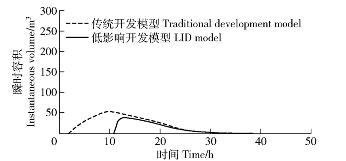
图 13 西十地块20年一遇24小时降雨出口径流曲线Figure 13. Runoff curve of 20-year-once 24 hour rainfall event in West 10 Plot![]() 图 14 外源雨水地块1年一遇24小时降雨雨水调蓄池瞬时容积变化曲线Figure 14. nstantaneous volume change curve of rain retention barrel of 1-year-once 24 hour rainfall event in exogenous site
图 14 外源雨水地块1年一遇24小时降雨雨水调蓄池瞬时容积变化曲线Figure 14. nstantaneous volume change curve of rain retention barrel of 1-year-once 24 hour rainfall event in exogenous site![]() 图 15 外源雨水地块2年一遇24小时降雨雨水调蓄池瞬时容积变化曲线Figure 15. Instantaneous volume change curve of rain retention barrel of 2-year-once 24 hour rainfall event in exogenous site
图 15 外源雨水地块2年一遇24小时降雨雨水调蓄池瞬时容积变化曲线Figure 15. Instantaneous volume change curve of rain retention barrel of 2-year-once 24 hour rainfall event in exogenous site![]() 图 16 外源雨水地块3年一遇24小时降雨雨水调蓄池瞬时容积变化曲线Figure 16. Instantaneous volume change curve of rain retention barrel of 3-year-once 24 hour rainfall event in exogenous site
图 16 外源雨水地块3年一遇24小时降雨雨水调蓄池瞬时容积变化曲线Figure 16. Instantaneous volume change curve of rain retention barrel of 3-year-once 24 hour rainfall event in exogenous site![]() 图 17 外源雨水地块5年一遇24小时降雨雨水调蓄池瞬时容积变化曲线Figure 17. Instantaneous volume change curve of rain retention barrel of 5-year-once 24 hour rainfall event in exogenous site
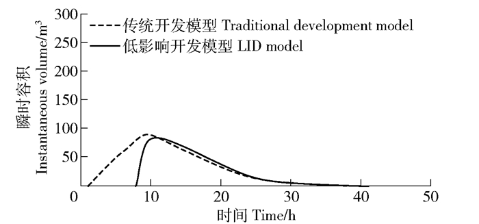
图 17 外源雨水地块5年一遇24小时降雨雨水调蓄池瞬时容积变化曲线Figure 17. Instantaneous volume change curve of rain retention barrel of 5-year-once 24 hour rainfall event in exogenous site![]() 图 18 外源雨水地块10年一遇24小时降雨雨水调蓄池瞬时容积变化曲线Figure 18. Instantaneous volume change curve of rain retention barrel of 10-year-once 24 hour rainfall event in exogenous site
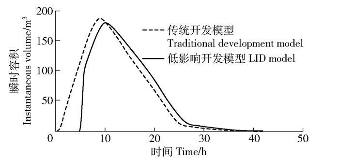
图 18 外源雨水地块10年一遇24小时降雨雨水调蓄池瞬时容积变化曲线Figure 18. Instantaneous volume change curve of rain retention barrel of 10-year-once 24 hour rainfall event in exogenous site![]() 图 19 外源雨水地块20年一遇24小时降雨雨水调蓄池瞬时容积变化曲线Figure 19. Instantaneous volume change curve of rain retention barrel of 20-year-once 24 hour rainfall event in exogenous site
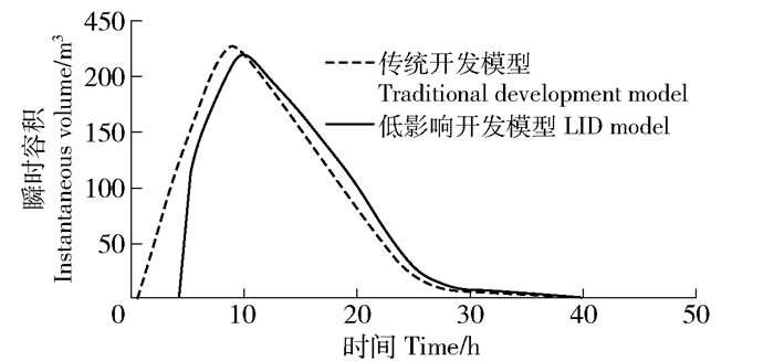
图 19 外源雨水地块20年一遇24小时降雨雨水调蓄池瞬时容积变化曲线Figure 19. Instantaneous volume change curve of rain retention barrel of 20-year-once 24 hour rainfall event in exogenous site(1) 根据表 3,通过低影响开发模型与传统开发模型结果数据对比,可知经过西十地块地表低影响开发设施后,在1年一遇、2年一遇、3年一遇、5年一遇、10年一遇及20年一遇降雨强度下出水口的径流总量分别削减100%、100%、100%、78.79%、50.41%、34.73%,峰值流量分别减少100%、100%、100%、70.12%、33.33%、19.44%,峰现时间为1年一遇、2年一遇、3年一遇峰值消失,5年一遇、10年一遇及20年一遇降雨强度下分别延迟375、310、240 min。由此得出结论:低影响开发模式可减少径流总量、峰值径流量,推迟峰现时间。外源雨水场地内LID设施除透水铺装外只有植草沟。由表 4可知,对比传统开发模式,低影响开发模式对场地径流总量的削减量较小,1年一遇、2年一遇、3年一遇、5年一遇、10年一遇、20年一遇重现期径流总量分别为800、2 633、4 189、6 145、10 249、13 970 m3,因此可将这部分径流收集到雨水调蓄池中用于西十地块浇灌。
(2) 根据图 8~19可知:低影响开发模式在降雨前期对地表瞬时径流量的削减能力较强;随着时间的推迟削减能力逐渐减弱,在降雨后期低影响开发设施承载容量趋于饱和,此时低影响开发模式下的出口径流量高于传统开发模式。
4.2 储蓄利用系统结果与分析
4.2.1 储蓄结果与分析
根据SWMM模拟结果,外源雨水地块全年总蓄水量为9 617 m3,径流收集主要集中在第25~35周;单周最大收水总量为2 078 m3,发生在第27周(6月初);第1~20周、43~52周收水量基本为0。
4.2.2 浇灌利用计算与分析
根据植物种类及北京气候类型,可推算出园林植物需水量:
PWR=ET0×KL (1) 式中:PWR为园林植物需水量,mm/d;ETO为参照作物需水量,mm/d;KL为园林系数。
根据彭曼-蒙蒂斯公式计算参照作物需水量:
ETo=0.408Δ(Rn−G)+γ900T+273u2(es−ea)Δ+γ(1+0.34u2) (2) 式中:ETO为参照作物需水量,mm/d;Rn为输入冠层净辐射量,MJ/m2·d;G为土壤热通量,MJ/m2·d;T为2 m高处日平均温度,℃;u2为2 m高处风速,m/s;es为饱和水汽压,kPa;ea为实际水汽压,kPa;Δ为饱和水汽压与温度关系曲线在某处得斜率,kPa/℃;γ为干湿温度计常数,kPa/℃。
园林系数(KL)的计算公式为:
KL=KsKdKme (3) 式中:Ks为园林植物种类因子;Kd为园林种植密度因子;Kmc为园林小气候因子。
园林植物净需水量:
PWRnet=PWR−Re (4) 式中:PWRnet为园林植物净需水量,mm/d;Re为有效降雨量,mm/d。
园林植物净灌溉需水量(IWRnet)是指存储于植物根区,可添加于土壤水库以满足净植物需水量(PWRnet)的那部分灌溉水量。
IWRnet=PWRnet (5) 为简化运算过程,将已报道的不同类型植物的种类系数、密度因子、小气候因子平均值[14](表 7)带入公式(3)得到冷季型草园林系数(KL)为0.8,其余植被类型园林系数(KL)为0.5。本研究参照北京市房山地区气象站20年(1982—2002年)常规观测气象数据,根据公式(2)计算出每月平均ETO值[16],估算出园林植物需水量PWR(表 8)。园林植物在不降雨或降雨不足时需要人工灌溉。将上述结果带入公式(1)计算得出不降雨时园林植物需水量速率;结合不同植被类型面积求得2017年每周西十场地园林植物灌溉需水量;与雨水调蓄池周容积量进行对比可知每周雨水利用率及雨水调蓄池空置率如图 20所示。由此,计算得出第25周、第27周、第29~32周、第34~35周、第41周雨水调蓄池中收集水量在满足当月灌溉需求后仍有余量;全年径流收集的利用率为43.65%;在冬季雨水调蓄池空置率较大。
![]() 图 20 2017年每周植物需水量与雨水调蓄池容积量关系图Figure 20. Diagram of weekly plant water requirement and rainwater storage of rain retention barrel in 2017表 7 各类园林植物园林系数相关指标及面积Table 7. Relevant indicators and area of KL for all kinds of garden plants
图 20 2017年每周植物需水量与雨水调蓄池容积量关系图Figure 20. Diagram of weekly plant water requirement and rainwater storage of rain retention barrel in 2017表 7 各类园林植物园林系数相关指标及面积Table 7. Relevant indicators and area of KL for all kinds of garden plants植被类型Vegetation type 种类系数Coefficient of species(Ks) 密度因子Density factor(Kd) 小气候因子Microclimatic factor(Kmc) 面积Area/m2 乔木Tree 0.9 0.5 0.2 1.3 1.0 0.5 1.4 1.0 0.5 灌木Shrub 0.7 0.5 0.2 1.1 1.0 0.5 1.3 1.0 0.5 地被植物Ground plant 0.9 0.5 0.2 1.1 1.0 0.5 1.2 1.0 0.5 12 400.5 树木、灌木、地被植物混合Mixed trees, shrubs and ground plants 0.9 0.5 0.2 1.3 1.0 0.6 1.4 1.0 0.5 冷季型草Cold season type grass 0.8 1.0 1.0 0.6 1.2 1.0 0.8 5 971.3 合计Total 18 371.8 表 8 2017年每月植物需水量Table 8. Monthly plant water requirement in 2017时间Time 1月Jan. 2月Feb. 3月Mar. 4月Apr. 5月May. 6月Jun. 7月Jul. 8月Aug. 9月Sep. 10月Oct. 11月Nov. 12月Dec. ETO/(mm·d-1) 0.72 1.20 2.17 3.38 4.26 4.72 4.21 3.74 3.02 2.00 1.19 0.72 PWR/(mm·d-1) 0.43 0.72 1.30 2.02 2.55 2.82 2.52 2.24 1.81 1.20 0.71 0.43 5. 结论
按照西十地块及外源雨水地块低影响开发系统雨水消纳能力应达到北京市3年一遇24 h降雨量(108 mm[9])的标准,经过上述设计研究及对SWMM模拟结果的定量分析可得出以下结论:
(1) 面对相同的雨洪调控目标,本研究根据基底条件和景观需求的差异制定不同的设计策略。西十地块优先构建渗透滞留系统,结合场地现状基底构建425.4 m2植草沟、1 035.8 m2生物滞留池、1 172.7 m2下沉式绿地、4 871.3 m2绿色屋顶以及6 647.8 m2透水铺装等5类LID设施;外源雨水地块以储蓄利用为目的,末端构建4 189 m3雨水调蓄池,最终均达到设计目标要求。
(2) 低影响开发设施对雨洪问题具有良好的调控效果,可以减少径流总量、峰值流量,推迟峰现时间,但随着时间的推迟削减能力逐渐减弱。由此可知,低影响开发系统的雨洪调控能力具有上限。
(3) 根据北京市2017年全年降雨量日值统计,外源雨水地块雨水调蓄池中径流收集的利用率为43.65%,有30周(210 d)雨水调蓄池空置率为100%,较为浪费。因此在进行低影响开发系统设计时,应综合考虑成本造价等因素。
致谢: 首钢西十项目前期资料是本文的关键工作基础。感谢北京清华同衡规划设计研究院有限公司朱育帆工作室将项目资料提供给研究团队。 -
![]()
图 6 首钢西十传统雨水系统平面图
Figure 6. Plan of traditional storm-water system in Shougang West 10 Plot
![]()
图 7 首钢西十传统雨水系统概化图
Figure 7. Generalized map of traditional storm-water system in Shougang West 10 Plot
![]()
图 8 西十地块1年一遇24小时降雨出口径流曲线
Figure 8. Runoff curve of 1-year-once 24 hour rainfall event in West 10 Plot
![]()
图 9 西十地块2年一遇24小时降雨出口径流曲线
Figure 9. Runoff curve of 2-year-once 24 hour rainfall event in West 10 Plot
![]()
图 10 西十地块3年一遇24小时降雨出口径流曲线
Figure 10. Runoff curve of 3-year-once 24 hour rainfall event in West 10 Plot
![]()
图 11 西十地块5年一遇24小时降雨出口径流曲线
Figure 11. Runoff curve of 5-year-once 24 hour rainfall event in West 10 Plot
![]()
图 12 西十地块10年一遇24小时降雨出口径流曲线
Figure 12. Runoff curve of 10-year-once 24 hour rainfall event in West 10 Plot
![]()
图 13 西十地块20年一遇24小时降雨出口径流曲线
Figure 13. Runoff curve of 20-year-once 24 hour rainfall event in West 10 Plot
![]()
图 14 外源雨水地块1年一遇24小时降雨雨水调蓄池瞬时容积变化曲线
Figure 14. nstantaneous volume change curve of rain retention barrel of 1-year-once 24 hour rainfall event in exogenous site
![]()
图 15 外源雨水地块2年一遇24小时降雨雨水调蓄池瞬时容积变化曲线
Figure 15. Instantaneous volume change curve of rain retention barrel of 2-year-once 24 hour rainfall event in exogenous site
![]()
图 16 外源雨水地块3年一遇24小时降雨雨水调蓄池瞬时容积变化曲线
Figure 16. Instantaneous volume change curve of rain retention barrel of 3-year-once 24 hour rainfall event in exogenous site
![]()
图 17 外源雨水地块5年一遇24小时降雨雨水调蓄池瞬时容积变化曲线
Figure 17. Instantaneous volume change curve of rain retention barrel of 5-year-once 24 hour rainfall event in exogenous site
![]()
图 18 外源雨水地块10年一遇24小时降雨雨水调蓄池瞬时容积变化曲线
Figure 18. Instantaneous volume change curve of rain retention barrel of 10-year-once 24 hour rainfall event in exogenous site
![]()
图 19 外源雨水地块20年一遇24小时降雨雨水调蓄池瞬时容积变化曲线
Figure 19. Instantaneous volume change curve of rain retention barrel of 20-year-once 24 hour rainfall event in exogenous site
![]()
图 20 2017年每周植物需水量与雨水调蓄池容积量关系图
Figure 20. Diagram of weekly plant water requirement and rainwater storage of rain retention barrel in 2017
表 1 各类LID设施设计要点
Table 1 Design points of LID facilities
区域Area 低影响开发设施LID facility 设计要点Design point 西十地块West 10 Plot 种植屋面Planting roof 将具备条件的平屋顶(6 495.1 m2)改建为可上人的屋顶花园,为办公人员提供多样活动空间的同时,在急降雨时可滞存一部分雨水以达到推迟峰现时间的目的The flat roof (6 495.1 m2) which can be converted into a roof garden provides office workers with a variety of activity spaces and retains rainwater in case of emergency rainfall to delay the peak time 透水铺装Permeable pavement 将场地中工业废弃物加工成透水混凝土砖,应用于地块内主园路(6 647.8 m2)Permeable concrete bricks which are processed from industrial wastes in the site applied to the main garden road (6 647.8 m2) in the plot 植草沟Vegetative swale 沿硬质边缘形成线性景观带(425.4 m2),以接纳铺装及绿地上的地表径流,将径流输送至雨水花园内部A linear landscape belt (425.4 m2) is formed along the hard edge to accept the surface runoff from pavement and green space and transport the runoff to the rain garden 下凹式绿地Rain garden 选择地块内部地势较低的区域集中布置两处下凹绿地(1 090.5 m2),一处位于建筑下沉庭院内,可就近接纳周边绿地及铺装上的地表径流;另一处利用下洼料场基址设计成90余米长的带状雨水花园,其为地表终端LID设施,接纳场地内全部径流Two concave green spaces (1 090.5 m2) are arranged centrally in the low-lying area inside the plot. One is located in the sunken courtyard of the building, which can receive the runoff of surrounding green space and pavement. Another site is designed as a belt rain garden more than 90 m long, which is the surface terminal LID facility and accepts all runoff in the site 生物滞留池Bio-retention cell 在人群活动量相对较小的地势低洼区域布置了1 035.8 m2的生物滞留池,当强降雨发生后,生物滞留池中一定时间内的雨水积蓄不影响场地的正常使用In low-lying areas with relatively small amount of population activity, 1 035.8 m2 of bio-retention cell was arranged. When heavy rainfall occurred, rainwater accumulation in the bio-retention cell within a certain period of time did not affect the normal use of the site 外源雨水地块Exogenous rainwater area 透水铺装Permeable pavement 将场地中工业废弃物加工成透水混凝土砖,应用于秀池北街、秀池东路人行道(7 422.0 m2)Permeable concrete bricks which are processed from industrial wastes in the site applied to the sidewalks of Xiuchi North Street and Xiuchi East Road (7 422.0 m2) 植草沟Vegetative swale 沿硬质边缘形成线性景观带(443.1 m2),以接纳铺装及绿地上的地表径流,将径流输送至雨水调蓄池中A linear landscape belt (443.1 m2) is formed along the hard edge to accept the surface runoff from pavement and green space and transport the runoff to the rain retention barrel 雨水调蓄池Rain retention barrel 外源雨水场地低处设置有雨水调蓄池,以接纳建筑屋顶雨水及全部地表径流。以设计目标为根据进行计算,外源雨水地块雨水调蓄池总容量为4 189 m3,方可达到消纳北京市3年重现期24 h降雨量这一目标。雨水调蓄池内雨水用于西十地块植物灌溉,并设有溢水口,当降雨强度超过地块内部LID设施消纳能力时,雨水通过溢水口排入市政雨水管网A rain retention barrel is installed at the lower level of the exogenous rainwater area to receive rainwater from the roof of the building and all surface runoff. According to the calculation based on the design objective, the total capacity of rain retention barrel in the exogenous rainwater area was 4 189 m3, which can reach the goal of absorbing 24-hour rainfall in the 3-year recurrence period of Beijing. Rainwater in the rain retention barrel is used for plant irrigation in the west 10 plot, and there is an overflow outlet. When the rainfall intensity exceeds the capacity of LID facilities inside the block, rainwater was discharged into the municipal rainwater pipe network through the overflow outlet  下载: 导出CSV
表 2 西十地块用地面积及用地比例表
Table 2 Table of West 10 Plot of land area and land use ratio
用地类型Type of land use 项目类型Item type 面积Area/m2 总面积Total area/m2 子项比例Subitem proportion/% 比例Proportion/% 绿化用地Green space 普通绿地Common green space 15 737.9 18 371.8 37.1 43.4 植草沟Vegetative swale 425.4 1.1 生物滞留池Bio-retention cell 1 035.8 2.4 下沉式绿地Rain garden 1 172.7 2.8 建筑占地Building space 屋顶花园绿地Green space of roof garden 4 871.3 14 987.3 11.5 35.7 屋顶花园铺装Impermeable pavement of roof garden 1 623.8 3.8 不上人硬质屋顶Hard roof of no people 8 492.2 20.4 园路及铺装场地用地Path and square 透水铺装Permeable pavement 6 647.8 8 954.4 15.6 20.8 不透水铺装Impermeable pavement 2 306.6 5.2 水体Water space 景观水体(不具备调蓄功能) Landscape water space (no regulating function) 52.3 52.3 0.1 0.1 合计Total 42 365.8 100
下载: 导出CSV
表 3 外源雨水地块用地面积及用地比例表
Table 3 Table of exogenous site of land area and land use ratio
用地类型Type of land use 项目类型Item type 面积Area/m2 总面积Total area/m2 子项比例Subitem proportion/% 比例Proportion/% 绿化用地Green space 普通绿地Common green space 15 967.6 16 410.7 27.5 28.3 植草沟Vegetative swale 443.1 0.8 建筑占地Building space 不上人硬质屋顶Hard roof of no people 16 865.1 16 865.1 29.1 29.1 园路及铺装场地用地Path and square 透水铺装Permeable pavement 7 422.0 24 740.1 12.8 42.6 不透水铺装Impermeable pavement 17 318.1 29.8 雨水调蓄池(地下) Rain retention barrel 雨水调蓄池(地下) Rain retention barrel (underground) 4 189 4 189 合计Total 58 015.9 100
下载: 导出CSV
表 4 传统开发模式用地面积及用地比例表
Table 4 Table of land area and land use ratio in traditional development model
项目类型Item type 面积Area/m2 比例Proportion/% 绿化用地Green space 34 782.5 34.7 建筑占地Building space 31 852.4 31.7 园路及铺装场地用地Path and square 33 694.5 33.5 水体Water space 52.3 0.1 雨水调蓄池(地下) Rain retention barrel (underground) 4 189 合计Total 100 381.7 100
下载: 导出CSV
表 5 西十地块不同降雨强度下的出水口径流量模拟结果
Table 5 Simulated results of West 10 Plot of the runoff under different rainfall intensities
模拟项目Simulation item 1年一遇(45 mm)24 h 1-year-once(45 mm)24 hour 2年一遇(81 mm)24 h 2-year-once(81 mm)24 hour 3年一遇(108mm)24 h 3-year-once(108 mm)24 hour 5年一遇(141 mm)24 h 5-year-once(141 mm)24 hour 10年一遇(209 mm)24 h 10-year-once(209 mm)24 hour 20年一遇(270 mm)24 h 20-year-once(270 mm)24 hour 低影响开发模式LID model 传统开发模式Traditional development model 差值Difference 低影响开发模式LID model 传统开发模式Traditional development model 差值Difference 低影响开发模式LID model 传统开发模式Traditional development model 差值Difference 低影响开发模式LID model 传统开发模式Traditional development model 差值Difference 低影响开发模式LID model 传统开发模式Traditional development model 差值Difference 低影响开发模式LID model 传统开发模式Traditional development model 差值Difference 径流总量Total runoff/m3 0 1 189 1 189 0 2 411 2 411 0 3 490 3 490 1 028 4 846 3 818 3 818 7 699 3 881 6 712 10 284 3 572 峰值流量Peak flow/(m3·s-1) 0 0.027 0.027 0 0.065 0.065 0 0.092 0.092 0.037 0.124 0.087 0.128 0.192 0.064 0.203 0.252 0.049 峰现时间Time of peak flow occurrence 消失Disappea- rance 09:01 消失Disappea- rance 09:00 消失Disappea- rance 09:00 15:15 09:00 375 min 14:10 09:00 310 min 13:00 09:00 240 min
下载: 导出CSV
表 6 外源雨水地块不同降雨强度下的出水口径流量模拟结果
Table 6 Simulated results of exogenous site of the runoff under different rainfall intensities
模拟项目Simulation item 1年一遇(45 mm)24 h 1-year-once(45 mm)24 hour 2年一遇(81 mm)24 h 2-year-once(81 mm)24 hour 3年一遇(108 mm)24 h 3-year-once(108 mm)24 hour 5年一遇(141 mm)24 h 5-year-once(141 mm)24 hour 10年一遇(209 mm)24 h 10-year-once(209 mm)24 hour 20年一遇(270 mm)24 h 20-year-once(270 mm)24 hour 低影响开发模式LID model 传统开发模式Traditional development model 差值Difference 低影响开发模式LID model 传统开发模式Traditional development model 差值Difference 低影响开发模式LID model 传统开发模式Traditional development model 差值Difference 低影响开发模式LID model 传统开发模式Traditional development model 差值Difference 低影响开发模式LID model 传统开发模式Traditional development model 差值Difference 低影响开发模式LID model 传统开发模式Traditional development model 差值Difference 径流总量Total runoff/m3 800 1 806 1 006 2 633 3 599 966 4 189 5 156 967 6 145 7 108 963 10 249 11 205 956 13 970 14 912 942 峰值流量Peak flow/(m3·s-1) 0.026 0.040 0.014 0.079 0.093 0.014 0.116 0.132 0.016 0.162 0.179 0.017 0.256 0.275 0.019 0.341 0.362 0.021 峰现时间Time of peak flow occurrence 12:20 09:01 119 min 10:45 09:00 105 min 10:15 09:00 75 min 10:10 09:00 70 min 10:00 09:00 60 min 09:55 08:58 57 min
下载: 导出CSV
表 7 各类园林植物园林系数相关指标及面积
Table 7 Relevant indicators and area of KL for all kinds of garden plants
植被类型Vegetation type 种类系数Coefficient of species(Ks) 密度因子Density factor(Kd) 小气候因子Microclimatic factor(Kmc) 面积Area/m2 乔木Tree 0.9 0.5 0.2 1.3 1.0 0.5 1.4 1.0 0.5 灌木Shrub 0.7 0.5 0.2 1.1 1.0 0.5 1.3 1.0 0.5 地被植物Ground plant 0.9 0.5 0.2 1.1 1.0 0.5 1.2 1.0 0.5 12 400.5 树木、灌木、地被植物混合Mixed trees, shrubs and ground plants 0.9 0.5 0.2 1.3 1.0 0.6 1.4 1.0 0.5 冷季型草Cold season type grass 0.8 1.0 1.0 0.6 1.2 1.0 0.8 5 971.3 合计Total 18 371.8
下载: 导出CSV
表 8 2017年每月植物需水量
Table 8 Monthly plant water requirement in 2017
时间Time 1月Jan. 2月Feb. 3月Mar. 4月Apr. 5月May. 6月Jun. 7月Jul. 8月Aug. 9月Sep. 10月Oct. 11月Nov. 12月Dec. ETO/(mm·d-1) 0.72 1.20 2.17 3.38 4.26 4.72 4.21 3.74 3.02 2.00 1.19 0.72 PWR/(mm·d-1) 0.43 0.72 1.30 2.02 2.55 2.82 2.52 2.24 1.81 1.20 0.71 0.43
下载: 导出CSV
-
[1] 柳笛.城市化对雨洪径流的影响:以武汉市为例[J].科技创业月刊, 2009, 22(1):66-67, 71. doi: 10.3969/j.issn.1672-2272.2009.01.031 Liu D. The impact of urbanization on rainwater runoff[J]. Pioneering with Science & Technology Monthly, 2009, 22(1):66-67, 71. doi: 10.3969/j.issn.1672-2272.2009.01.031
[2] 彭攀.基于海绵城市理念的市政道路滞留带研究[D].南京: 东南大学, 2017. http://cdmd.cnki.com.cn/Article/CDMD-10286-1018003853.htm Peng P. The research of road retention band based on sponge city concept[D].Nanjing: Southeast University, 2017. http://cdmd.cnki.com.cn/Article/CDMD-10286-1018003853.htm
[3] 席璐, 石丽忠, 周庆芳.基于SWMM模型的海绵城市小区建设雨洪过程模拟:咸阳市某小区为例[J].沈阳大学学报(自然科学版), 2018, 30(3):244-249. http://d.old.wanfangdata.com.cn/Periodical/shenydxxb201803015 Xi L, Shi L Z, Zhou Q F. Simulation of rainwater process of residential district in spongy city based on SWMM model: taking a residential district in Xianyang as an example[J].Journal of Shenyang University(Natural Science), 2018, 30(3):244-249. http://d.old.wanfangdata.com.cn/Periodical/shenydxxb201803015
[4] 张译心, 于富鑫, 黄晨霞, 等.基于SWMM模型的小区低影响开发措施组合模式的效果模拟评估[J].科技创新与应用, 2018(13):50-52. http://d.old.wanfangdata.com.cn/Periodical/qgsj201813020 Zhang Y X, Yu F X, Huang C X, et al. Effect simulation evaluation of the combined model of small development measures with low impact based on SWMM model[J].Technology Innovation and Application, 2018(13):50-52. http://d.old.wanfangdata.com.cn/Periodical/qgsj201813020
[5] 贾博, 许荷.基于SWMM的多情景海绵城市设施组合效用研究:以北京大兴某公园为例[J].建设科技, 2018(3):56-57. doi: 10.3969/j.issn.1005-6637.2018.03.018 Jia B, Xu H. A study on the combined utility of multi-scenario sponge city facilities based on SWMM: taking a park in daxing, Beijing as an example[J]. Construction Science and Technology, 2018(3):56-57. doi: 10.3969/j.issn.1005-6637.2018.03.018
[6] 林辰松, 邵明, 葛韵宇, 等.基于SWMM情境模拟的外源雨水型公园绿地雨洪调控效果研究[J].北京林业大学学报, 2016, 38(12):92-103. doi: 10.13332/j.1000-1522.20160260 Lin C S, Shao M, Ge Y Y, et al.Research of storm flood regulation efficiency of the low impact development of exogenous-rainwater park based on the SWMM simulation[J]. Journal of Beijing Forestry University, 2016, 38(12): 92-103. doi: 10.13332/j.1000-1522.20160260
[7] 时薏, 李运远, 戈晓宇, 等.华北地区城市浅山区海绵绿道设计方法研究:以石家庄鹿泉区山前大道为例[J].北京林业大学学报, 2017, 39(11):82-91. doi: 10.13332/j.1000-1522.20170289 Shi Y, Li Y Y, Ge X Y, et al. Design methods of sponge greenway in urban shallow mountainous area in northern China: taking the greenway of Luquan District in Shijiazhuang as an example[J].Journal of Beijing Forestry University, 2017, 39(11):82-91. doi: 10.13332/j.1000-1522.20170289
[8] 宋晓猛, 张建云, 孔凡哲, 等.北京地区降水极值时空演变特征[J].水科学进展, 2017, 28(2):161-173. http://d.old.wanfangdata.com.cn/Periodical/skxjz201702001 Song X M, Zhang J Y, Kong F Z, et al. Spatio-temporarl variation characteristics of precipitation extremes in Beijing[J]. Advances in Water Science, 2017, 28(2):161-173. http://d.old.wanfangdata.com.cn/Periodical/skxjz201702001
[9] 刘强, 康晓鹍, 翟立晓, 等.北京市《雨水控制与利用工程设计规范》规划指标解读[J].给水排水, 2014, 50(10):84-88. doi: 10.3969/j.issn.1002-8471.2014.10.025 Liu Q, Kang X K, Zhai L X, et al.Interpretation of standard planning indexes of rainwater control and utilization engineering in Beijing[J]. Water & Wastewater Engineering, 2014, 50(10):84-88. doi: 10.3969/j.issn.1002-8471.2014.10.025
[10] 仇保兴.海绵城市(LID)的内涵、途径与展望[J].给水排水, 2015, 51(3):1-7. http://d.old.wanfangdata.com.cn/Periodical/jskj201501005 Qiu B X. The connotation, pathway and expectation of LID[J]. Water & Wastewater Engineering, 2015, 51(3):1-7. http://d.old.wanfangdata.com.cn/Periodical/jskj201501005
[11] 王文亮, 李俊奇, 宫永伟, 等.基于SWMM模型的低影响开发雨洪控制效果模拟[J].中国给水排水, 2012, 28(21):42-44. doi: 10.3969/j.issn.1000-4602.2012.21.012 Wang W L, Li J Q, Gong Y W, et al. LID stormwater control effect simulation based on SWMM[J].China Water & Wastewater, 2012, 28(21):42-44. doi: 10.3969/j.issn.1000-4602.2012.21.012
[12] Rossman L A. Storm water management model user's manual version 5.0[M]. Washington D C: United States Environmental Protection Agency, 2010.
[13] 吴晓瑜, 黄维, 周密.基于SWMM的某工业园区LID方案及模拟评估[J].中国给水排水, 2017, 33(11):139-142. http://www.wanfangdata.com.cn/details/detail.do?_type=perio&id=zgjsps201711028 Wu X Y, Huang W, Zhou M. Low impact development planning and evaluation in an industrial park based on SWMM simulation[J].China Water & Wastewater, 2017, 33(11):139-142. http://www.wanfangdata.com.cn/details/detail.do?_type=perio&id=zgjsps201711028
[14] 邱振存, 管健.园林绿化植物灌溉需水量估算[J].节水灌溉, 2011(4):48-50, 54. http://www.wanfangdata.com.cn/details/detail.do?_type=perio&id=jsgg201104014 Qiu Z C, Guan J.Estimation of water demand for landscaping plants[J].Water Saving Irrigation, 2011(4): 48-50, 54. http://www.wanfangdata.com.cn/details/detail.do?_type=perio&id=jsgg201104014
[15] 刘伯英.城市污染工业用地的生态修复[C]//第三届国际智能、绿色建筑与建筑节能大会智能与绿色建筑文集.北京: 清华大学, 2007: 684-691. Liu B Y.The bio-remediation of urban polluted industry district[C]//The 3rd International Conference on Intelligent Green and Energy Efficient Building. Beijing: Tsinghua University, 2007: 684-691.
[16] 冷俊杰.北京房山节水灌溉区作物需水量(ET)的计算与研究[D].乌鲁木齐: 新疆大学, 2004. http://cdmd.cnki.com.cn/Article/CDMD-10755-2004118373.htm Leng J J. Evaluation and research of crop water requirements(ET) in the water-saving irrigation area of Beijing Fangshan[D]. Urumqi: Xinjiang University, 2004. http://cdmd.cnki.com.cn/Article/CDMD-10755-2004118373.htm
-
期刊类型引用(6)
1. 莫崇杏,董明亮,李荣生,余纽,郑显澄,杨锦昌. 米老排杂交子代苗期生长性状遗传变异及选择. 森林与环境学报. 2023(05): 555-560 .  百度学术
百度学术
2. Shuchun Li,Jiaqi Li,Yanyan Pan,Xiange Hu,Xuesong Nan,Dan Liu,Yue Li. Variation analyses of controlled pollinated families and parental combining ability of Pinus koraiensis. Journal of Forestry Research. 2021(03): 1005-1011 . 必应学术
3. 潘艳艳,许贵友,董利虎,王成录,梁德洋,赵曦阳. 日本落叶松全同胞家系苗期生长性状遗传变异. 南京林业大学学报(自然科学版). 2019(02): 14-22 . 百度学术
4. 秦光华,宋玉民,乔玉玲,于振旭,彭琳. 旱柳苗高年生长与气象因子的灰色关联度. 东北林业大学学报. 2019(05): 42-45+51 . 百度学术
5. 李峰卿,陈焕伟,周志春,楚秀丽,徐肇友,肖纪军. 红豆树优树种子和幼苗性状的变异分析及优良家系的初选. 植物资源与环境学报. 2018(02): 57-65 . 百度学术
6. 张素芳,张磊,赵佳丽,张莉,张含国. 长白落叶松小RNA测序和其靶基因预测. 北京林业大学学报. 2016(12): 64-72 . 本站查看
其他类型引用(6)


计量
- 文章访问数: 1411
- HTML全文浏览量: 314
- PDF下载量: 33
- 被引次数: 12
