
Construction of green space planning framework based on ecosystem service function simulation: a case study of shallow mountain area in Beijing
-
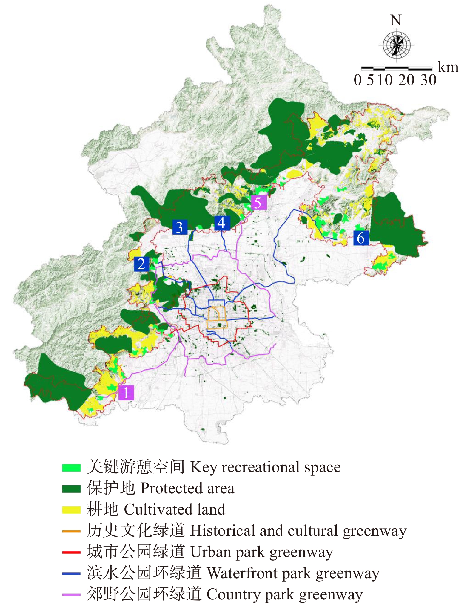
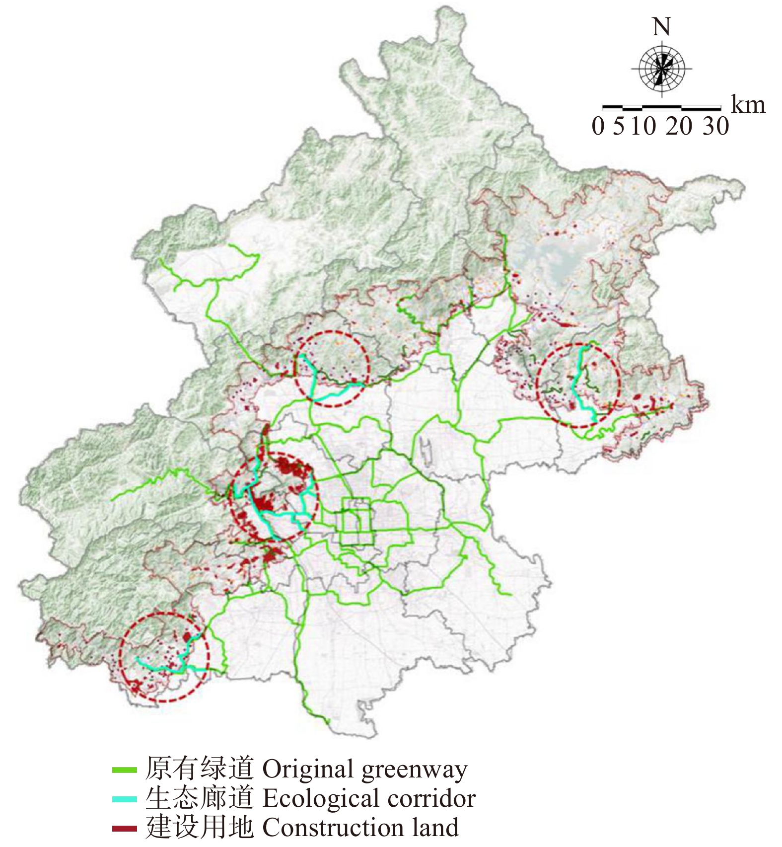
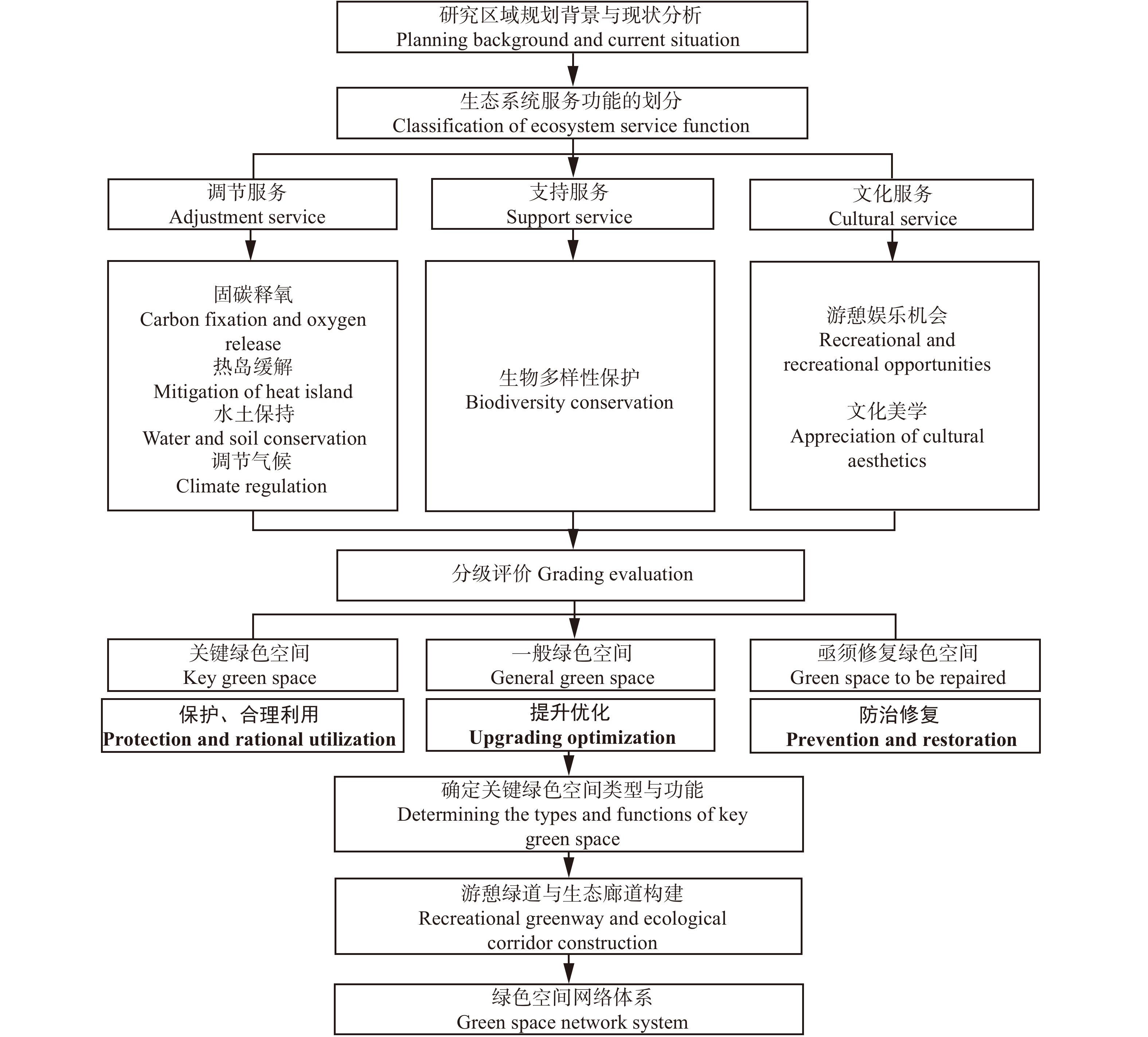
摘要:目的在快速城镇化以及全球气候变化的背景下,生态环境不断恶化给人类生活和健康带来了巨大的影响。生态系统服务功能评估作为一种应对气候变化、构建绿色宜居生存环境的方法得到推广。建立基于生态系统服务功能模拟演算的绿色空间规划框架,对于客观评价绿色空间的服务功能、构建可持续发展的绿色空间网络具有科学的指导意义。方法本文在总结国内外学者相关研究的基础上,以北京市浅山地区为例,构建基于生态系统服务功能评估的绿色空间规划框架,选取缓解热岛效应、水土保持、固碳释氧、气候调节、生物多样性保护、文化娱乐6种功能指标,采用径流系数公式计算、MaxEnt模型模拟等方法进行评价,识别区域不同服务类型的关键绿色空间位置并提出适宜的绿色空间类型,最后通过构建游憩绿道以及生态廊道加强绿色空间联系,完善绿色空间布局。结果不同类型生态系统服务效益空间分布呈现一定差异性,根据不同区域提供的服务差异划定湿地公园、森林公园、郊野公园、城市公园、地质公园、风景名胜区以及生态保育绿地7种绿色空间类型,新增6条绿道(195 km)连接平原与浅山区,在温泉镇、延寿镇、十三陵镇、峪口镇等村镇构建生态廊道,建立以目标动物保护为目的的线性绿色空间。结论绿色空间能够提供多种重要的生态系统服务功能,构建绿色空间规划框架对于加强落实浅山区生态优先的发展战略,推动形成可持续的绿色发展方式有重要意义。Abstract:ObjectiveIn the context of rapid urbanization and global climate change, the deterioration of the ecological environment has brought tremendous impact on human life and health. Ecosystem service function assessment has been promoted as a method to cope with climate change and build a green and livable living environment. Establishing a green space planning framework based on ecosystem service function simulation calculus has scientific guiding significance for objectively evaluating the service function of green space and building a sustainable green space network.MethodOn the basis of summarizing the relevant research of scholars at home and abroad, this paper takes the shallow mountain area of Beijing as an example to construct a green spatial planning framework based on the assessment of ecosystem service function. Six functional indicators, namely, heat island mitigation, soil and water conservation, carbon sequestration and oxygen release, climate regulation, biodiversity conservation and cultural recreation, were selected, and runoff was adopted. Coefficient formula calculation, MaxEnt model simulation and other methods were used to evaluate, identify the location of key green spaces of different service types in the region and propose suitable green space types. Finally, through the construction of recreational greenways and ecological corridors, green space links were strengthened and the layout of green space was improved.ResultThe results showed that the spatial distribution of ecosystem service benefits of different types showed some differences. According to the service differences provided by different regions, seven types of green space were delimited, including wetland park, forest park, country park, urban park, geological park, scenic spot and ecological conservation green space. Six new green roads were added. In plain and shallow mountainous area, ecological corridors were constructed in villages and towns such as Hot Spring Town, Yanshou Town, Shisanling Town and Yukou Town, and linear green space for the purpose of protecting target animals was established.ConclusionThe aim is to strengthen the implementation of ecological priority development strategy in shallow mountain areas and promote the formation of sustainable green development mode.
-
防浪林是种植于堤防迎水侧滩地上用于防浪护堤和抢险取材的专用林,既可以保持水土、调节气候、促进林业经济发展,又可以防浪消能、延长堤防寿命和减少堤防的维护费用,是堤防工程的重要组成部分[1-2]。目前我国各大江河堤岸的重要河段均种植了防浪林,且根据不同河段的实际情况,实施了不同的防浪林建设方案。物理模型实验是研究防浪林消浪机理的一个有效手段,对科学提出防浪林优化布局以及如何营造防浪林工程有重要理论指导意义和实用价值。目前已有很多学者进行了相关的物理实验研究。何飞等[3]在考虑植物根、茎、叶影响下设计水槽实验探究刚性植物的消浪特性,认为根、茎、叶均在不同程度上影响植物消浪特性。陈杰等[4]在研究刚性植物根、茎、叶对植物消波特性的影响中得出植物消波特性与植物淹没度有关,根、茎、叶的存在增加了植物拖曳力系数。陈杰等[5]还通过物理实验研究了规则波通过非淹没刚性植物波高的沿程变化,实验结果表明相比于矩形分布方式,三角形的分布方式消耗了更多的波能,消浪效果更明显。
以上相关的物理实验研究主要是针对植被本身的特性以及排列方式对消浪效果的影响,缺乏对林带宽度、植被密度、滩地波高等因素的考虑,以及不规则波条件下植被对消浪效果的影响。
本文以嫩江干流佰大街堤防为例,选取防浪林林带宽度、排列方式、密度、树型以及滩地波高作为影响因素,采用控制变量法,通过构建防浪林消浪物理模型研究其对消浪效果的影响,并提出合理的防浪林优化设计方案。
1. 研究区概况
嫩江干流佰大街堤防位于黑龙江省齐齐哈尔市泰来县境内,自汤池镇愚公堤经佰大街村至李地房子,堤防分为上、中、下3段,全长6.70 km。原佰大街堤上下段中间为高地相连,后因村民在高地附近修建民房,不断从高地取土,导致现有高地地面高程减少,最低处地面高程141.5 m,远低于此处河道50年一遇洪水位144 m,造成了防洪缺口。现状堤防属于扩建砂堤,筑堤土料比较松散,抗冲刷能力较弱,容易产生流土、管涌等现象。嫩江该河段高水位时,水面宽阔,堤前滩地现有防浪林1.0 km,多为5 ~ 8年生的杨树(Populus spp.)和少量柳树(Salix spp.)。预计规划新建防浪林10 km。该段堤防防洪标准目前仅为30 ~ 35年一遇。佰大街堤防如图1所示。
2. 物理模型设计
2.1 模型比尺确定
模型比尺的确定主要依据实验条件、波浪要素、造波机性能等因素,并综合考虑比尺效应带来的误差影响等。已有的物理模型实验研究中,王瑞雪[6]选择几何比尺1∶20,在长40 m× 宽0.5 m × 高0.8 m 的水槽中进行非刚性植物对波浪传播变形影响的实验研究;吉红香[7]选择几何比尺为1∶10,在长66 m × 宽1.0 m × 高1.6 m的水槽中研究滩地植物对波浪变形及消浪效果的影响。
本实验是在不规则波浪水槽中进行。为了消除比尺效应,更好的模拟嫩江干流防浪林的消浪效果,依据实际条件下防浪林的植被生长能力、波浪要素以及现有实验设备条件,结合实验方案的设计,对比造波机实际可造波周期,依照周期比例确定模型几何比尺,并根据重力相似准则确定时间比尺,最终确定本模型采用的比尺为1∶10。其中比尺确定公式[8]如(1)所示。
λ=lmlp,λt=λ−1/2,λf=λ1/2λu=λ−1/2,λF=λ−3,λQ=λ−5/2 (1) 式中:
λ 为模型长度比尺;lp 为原型长度;lm 为模型长度;λt 为时间比尺;λf 为频率比尺;λu 为速度比尺;λF 为力比尺;λQ 为流量比尺。2.2 实验方案与依据
关于植被消浪的物理模型实验设计方面,白玉川等[9]用裁减的桧柏(Sabina chinensis)枝模拟防浪林,研究了非破碎波条件下的防浪林消浪效果。胡嵋等[10]对于在堤岸上栽种植被消浪这一新的护岸工程,选取桧柏树枝作为防浪林的模型,择选出对消浪护岸具有主要影响的因素。王瑞雪[6]用PVC塑料圆管来模拟刚性植物树干进行波浪水槽物理模型实验。吴迪等[11]和曹海锦等[12]也分别利用聚乙烯仿真绿色植物模拟柔性植物进行柔性植物消浪及沿程阻流特性实验研究。通过不同的研究可以发现影响消浪效果的主要因素为防浪林林带宽度、排列方式、种植密度、林木高度等。
针对不同的实际条件,物理模型的设计方案有一定的差异,需根据实际情况和需要来设计实验方案。本实验根据嫩江干流的实际条件及水文资料,推算佰大街堤防典型断面的多年一遇水位高程及波要素极值,对比分析不同条件下波浪沿程衰减的变化。由于防浪林消浪效果的影响因素较多,因而本模型实验采用控制单因素变量法,得出各因素对消浪效果的影响。本实验中设计的主要对比方案有:不同的防浪林林带宽度、不同的防浪林排列方式、不同的防浪林密度、不同树型的防浪林、以及不同的来波波高等的消浪实验方案。分析不同实验方案条件下的消浪效果,提出该段的防浪林优化布局方案。
根据研究区实际防浪林植被的外形参数,包括树高、树干直径、树冠直径、树冠以下树干高度等,按照比尺计算模型树的外形参数,根据所需材料的尺寸对模型树进行修剪和黏合,植物树干采用圆形木棒模拟,植物树冠部分采用塑料仿真枝叶模拟,由此制作合适的模型树,如图2所示。
同时,为更好的定量分析防浪林消浪机理,定义
q 为防浪林植被消浪系数:q=(h−h′)/h (2) 式中:
h 为无防浪林的波高,h′ 为经过防浪林消波后的波高。2.3 实验断面和波要素的选取
佰大街断面50年一遇洪水条件下滩地平均水深为2.83 m,此时防浪林处于部分淹没状态。依据该断面多年一遇水位及波浪要素值的推算结果中50年一遇的波要素,得出该堤段波浪周期在2 ~ 4 s之间,平均波高在0.1 ~ 0.6 m之间。根据《海港水文规范》推算出相应的1/10大波(规则波)波高,Hs(不规则波)有效波高,分别进行了规则波和不规则波消浪效果的模拟实验,实验波要素分别为1/10波高1.16 m、有效波高0.91 m、平均波高0.57 m、平均周期3.01 m。此外,为进一步研究不同波要素条件下防浪林消浪效果的差异,选取了1.1倍和0.9倍50年一遇波高条件进行对比实验。
2.4 实验设备及布置
本实验是在河海大学海岸工程实验大厅70 m长的不规则波浪水槽中进行,水槽宽1.0 m,高1.8 m,有效实验段宽1 m。水槽一端安装了推板式不规则生波机,通过电机系统控制推波板运动行程和频率[13]。数字波高仪采用YWS200-XX型,波高采集系统采用水工试验数据采集处理系统(DJ800型),精度为0.01 cm。所有量测信号均通过计算机采集、记录和分析,能模拟最大波高0.3 m、波周期0.5 ~ 5 s的不规则波,具备研究不规则波作用下的各种动力响应机制及波浪与建筑物相互作用关键技术和理论问题的能力。水槽底部铺设灰色混凝板,在灰塑料板上打孔用以固定植物模型。水槽左侧为造波机,波高传感器两个,分别布设在防浪林模型前后,采集波高的变化。最右侧为消波层,能够有效地吸收尾波的波能,避免波浪的反射对实验造成干扰(实验布置和实验实景图分别如图3和图4所示)。
3. 防浪林消浪机理物理实验结果分析
3.1 不同防浪林林带宽度和防浪林排列方式的消浪结果
根据实验方案,进行了佰大街断面在不同排列方式(等边三角形、正方形及梅花形,如图5 ~ 7所示)条件下的消浪实验。由于模型比尺为1∶10,因此根据佰大街的种植现状,确定实验室条件下的防浪林植被密度为17株/m2,树干直径为0.7 cm,树干高度为16 cm,树冠直径为13 cm,树冠为高度8 cm。规则波和不规则波条件下的实验结果分别如图8和图9所示。
![]() 图 8 不同排列方式规则波沿程消浪系数Figure 8. Regular wave dissipation coefficient along the path of different arrangements
图 8 不同排列方式规则波沿程消浪系数Figure 8. Regular wave dissipation coefficient along the path of different arrangements![]() 图 9 不同排列方式不规则波沿程消浪系数Figure 9. Irregular wave dissipation coefficient along the path of different arrangements
图 9 不同排列方式不规则波沿程消浪系数Figure 9. Irregular wave dissipation coefficient along the path of different arrangements对比不同的防浪林排列方式下防浪林的消浪效果,可见在规则波条件下,当林带宽度在40 m以上时,等边三角形和梅花形排列的防浪林要明显优于正方形排列;在不规则波条件下,当林带宽度在40 m以上时,等边三角形和正方形排列的防浪林要明显优于梅花形排列。因此,等边三角形排列方式相对较优。这与陈杰等[5]通过物理实验研究规则波通过非淹没刚性植物波高的沿程变化中得出三角形分布方式消浪效果最明显的结论一致。对比相同防浪林林带宽度下的规则波和不规则的消浪效果,可以发现规则波条件下防浪林的消浪系数较大,但两者差距较小。而实际条件下的波浪为不规则波,因而不规则波的消浪系数更为接近实际条件。
同时,还可以发现,不管是规则波还是不规则波条件下,随着林带宽度增加到30 m以后,防浪林的消浪系数对于林带宽度的敏感度降低,此时消浪效果提升空间很小。
3.2 不同密度的防浪林消浪效果
根据实验方案,进行了在不同密度的防浪林(实验室条件下8株/m2,17株/m2,27株/m2)条件下的消浪实验。其中实验室条件下树型为,树干直径0.7 cm,树干高度16 cm,树冠直径13 cm,树冠高度8 m。采用不规则波,实验结果如图10所示。
![]() 图 10 不同密度不规则波沿程消浪系数Figure 10. Irregular wave dissipation coefficient along the path of different densities
图 10 不同密度不规则波沿程消浪系数Figure 10. Irregular wave dissipation coefficient along the path of different densities对比不同密度的防浪林的消浪效果,可以发现,当防浪林林带宽度为10 m时,不同密度的防浪林消浪效果差别不大,均为8%左右;当防浪林林带宽度大于10 m时,防浪林的消浪效果随着密度的增加而增加,密度27株/m2比密度8株/m2的消浪系数大5%到10%。但过高的密度会影响防浪林树木的正常生长,而且种植成本较高。可见,当林带宽度为40 m,排列方式为等边三角形时,0.17株/m2(原型条件)是较为经济合理的植被密度方案。此时,当防浪林林带宽度进一步增大50 m时,防浪林的消浪系数仅增加3.04%。
3.3 不同树型的防浪林消浪效果
根据实地测量,选取了4种树型作为树干和树冠条件的组合,如表1所示,采用相对较优的等边三角形排列方式,实验室条件下防浪林密度为17株/m2。规则波和不规则波条件下的模型实验结果分别如图11和图12所示。
表 1 树型尺寸Table 1. Tree size项目
Item树型1
Tree type 1树型2
Tree type 2树型3
Tree type 3树型4
Tree type 4树干高度
Trunk height/m0.26 0.26 0.26 0.16 树干半径
Trunk radius/m0.025 0.015 0.015 0.007 树冠高度
Crown height/m0.35 0.35 0.35 0.08 树冠直径
Crown radius/m0.25 0.25 0.17 0.13 ![]() 图 11 不同树型规则波沿程消浪系数Figure 11. Regular wave dissipation coefficient along the path of different tree types
图 11 不同树型规则波沿程消浪系数Figure 11. Regular wave dissipation coefficient along the path of different tree types![]() 图 12 不同树型不规则波沿程消浪系数Figure 12. Irregularwave dissipation coefficient along the path of different tree types
图 12 不同树型不规则波沿程消浪系数Figure 12. Irregularwave dissipation coefficient along the path of different tree types由以上结果可见,不同树型的消浪效果有着明显的差异。树型1(成年树)树干较粗,树冠较为茂密,茂密的根、茎、叶存在增加了植物拖曳力系数,因而消浪能力显著,规则波条件下,20 m宽的防浪林其消浪系数即达60%左右,50 m宽防浪林的消浪系数可达到80%以上。
树型2相对树型1的差别为树干半径较小,由消浪实验结果可见,树干的粗细对消浪效果的影响较小。树型3的消浪系数要小于树型2。而树型4(幼树)的消浪效果明显小于树型1、树型2和树型3。可见,不同防浪林树型对同一断面条件下的消浪效果有着重要的影响,对比其消浪系数可知,树冠的消浪作用要明显强于树干,因而在防浪林方案设计时,需考虑采用树冠消浪为主的方法。
3.4 不同来波波高影响下消浪效果
根据实验方案,进行了在不同来波波高(1.1倍50年一遇波高、50年一遇波高、0.9倍50年一遇波高)条件下的消浪实验。采用相对较优的等边三角形排列方式,实验室条件下,树干直径0.7 cm,树干高度16 cm,树冠直径13 cm,树冠高度8 cm。规则波和不规则波条件下的模型实验结果分别如图13和图14所示。
![]() 图 13 不同波高规则波沿程消浪系数Figure 13. Regular wave dissipation coefficient along the path of different wave heights
图 13 不同波高规则波沿程消浪系数Figure 13. Regular wave dissipation coefficient along the path of different wave heights![]() 图 14 不同波高不规则波沿程消浪系数Figure 14. Irregular wave dissipation coefficient along the path of different wave heights
图 14 不同波高不规则波沿程消浪系数Figure 14. Irregular wave dissipation coefficient along the path of different wave heights由图13和图14可见,不同波高条件下的消浪效果有所差异,但差异较小,且不规则波的消浪系数变化更为稳定。波高越大,消浪效果越好。
4. 结 论
嫩江干流佰大街堤防段,在合理的防浪林树型条件下,等边三角形排列的防浪林要优于梅花形和正方形排列方式;密度的增加对防浪林消浪效果有着一定的提高,但过高的密度会影响防浪林树木的正常生长;不同树型对不同断面条件的消浪效果有着重要的影响,且树冠的消浪作用要明显强于树干。不同波高条件下的消浪效果有所差异,但差异较小,且不规则波的消浪系数变化更为稳定。
-
表 1 主要研究方法和技术手段
Table 1 Main research methods and technical means
类型 Type 方法 Method 具体内容 Concrete content 指数分析法
Exponential analysis指标分析
Index analysis土地利用变化率、土地利用程度、景观格局指数、径流系数等
Land use change rate, land use degree, landscape pattern index, runoff coefficient, etc.数学方法分析
Mathematical method相关分析与多元回归分析、主成分分析、敏感性分析
Correlation analysis, multiple regression analysis, principal component analysis and sensitivity analysis市场价值法
Market value method直接市场价值法
Direct market value method生态系统提供的服务可以根据实际或替代物质量的价值市场价格直接进行衡量
Services provided by ecosystems can be measured directly according to the value market price of actual or alternative substances间接市场价值法
Indirect market value method通过估算其替代品的价值对生态系统服务进行间接估算,其中最常用的包括机会成本法、生产成本法、影子工程法
Indirect estimates of ecosystem services are made by estimating the value of alternatives, including opportunity cost method, production cost method and shadow engineering method模型模拟法
Model simulation methodMaxent 模拟物种潜在区域,进行生物多样性评估
Simulating potential areas of species for biodiversity assessment生态检测分析
Ecotect Analysis模拟通风潜力区域
Simulated ventilation potential areai-TREE 对森林生态效益、经济效益评估
Assessment of ecological and economic benefits of forests耗费距离模型
Consumption distance model模拟重要生态廊道,优化城市景观结构
Simulating the important ecological corridor and optimizing the urban landscape structure动态情景模拟分析Dynamic simulation scenario analysis InVEST 模拟不同土地覆被情景下生态服务系统物质量和价值量的变化
Simulating the changes of material and value of ecosystem services under different land cover scenariosCLUE-S、FLUS 兼顾土地利用系统中的社会经济和生物物理驱动因子, 并在空间上反映土地利用变化的过程和结果
Considering socio-economic and biophysical driving factors in land use system and reflecting the process and results of land use change in spaceCA_MARKOV 对土地利用结构数量及空间分布进行预测
Predicting the quantity and spatial distribution of land use structureLCM 快速分析土地覆盖变化,根据经验建模与解释变量的关系,并模拟未来的土地变化情景
Rapid analysis of land cover change, empirical modeling and interpretation of the relationship between variables, and simulation of future land change scenarios 下载: 导出CSV
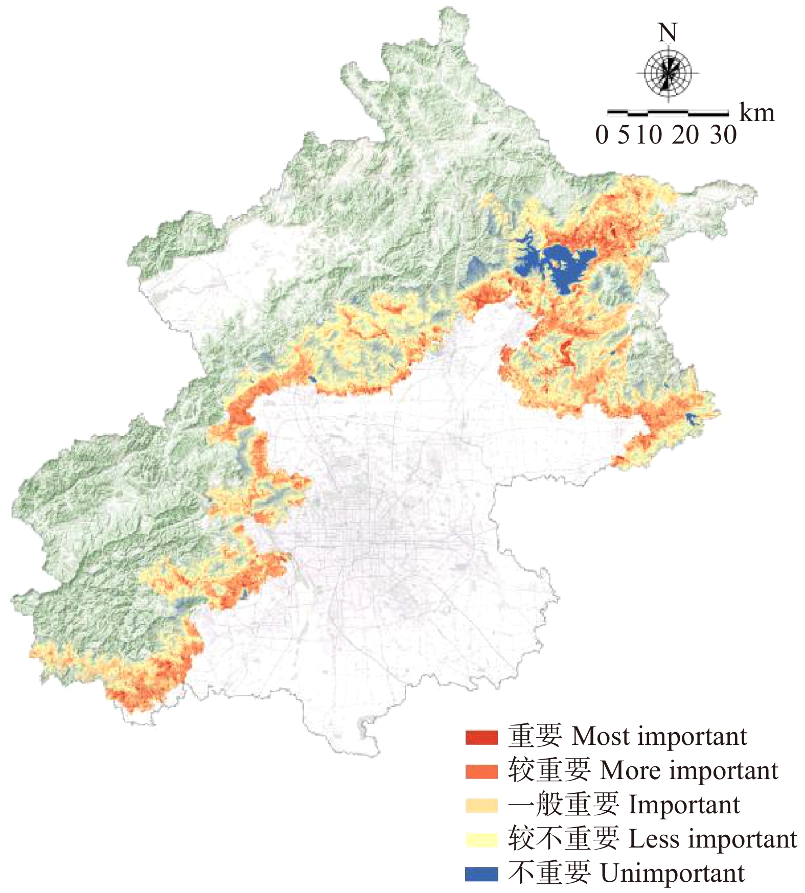
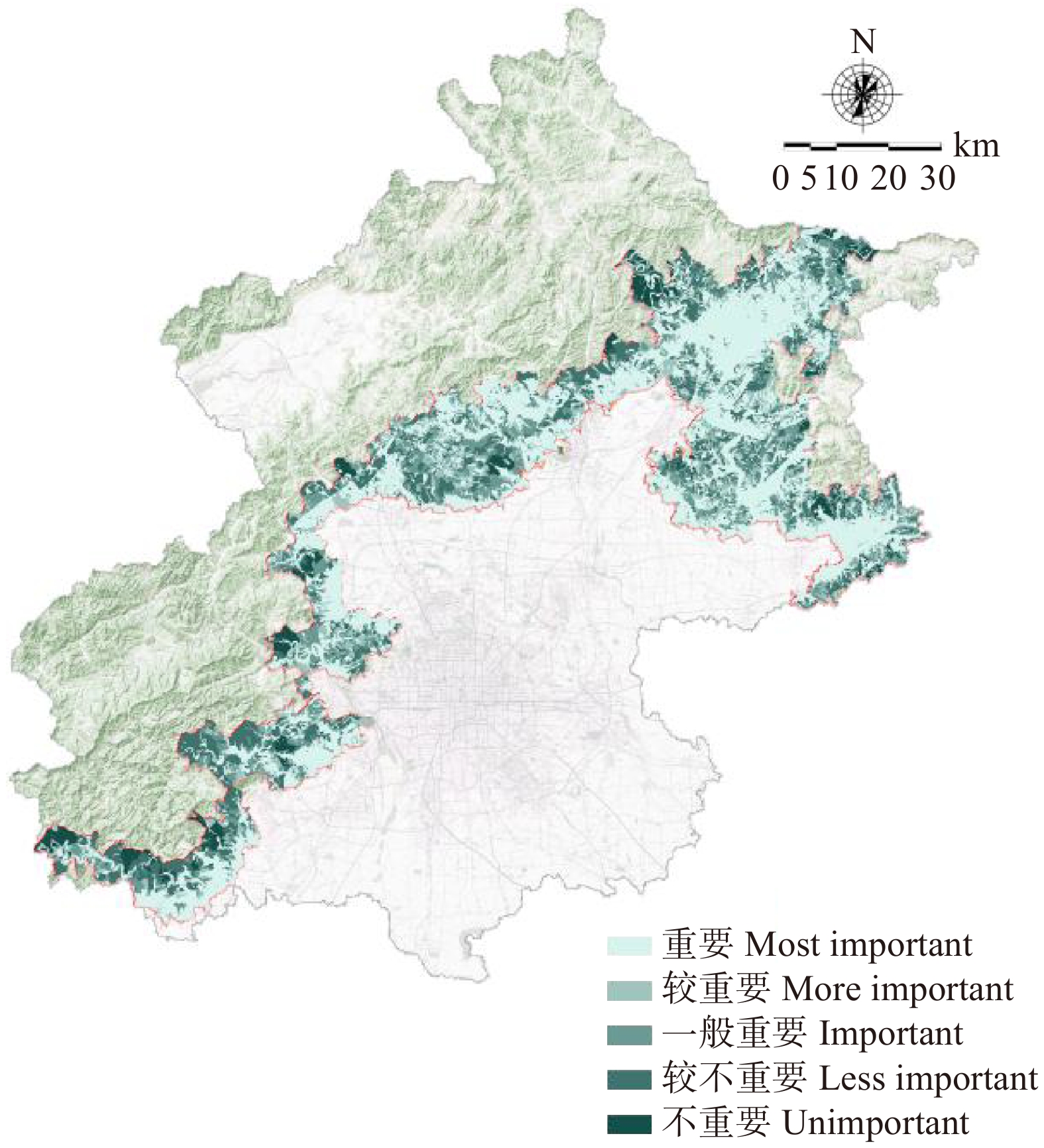
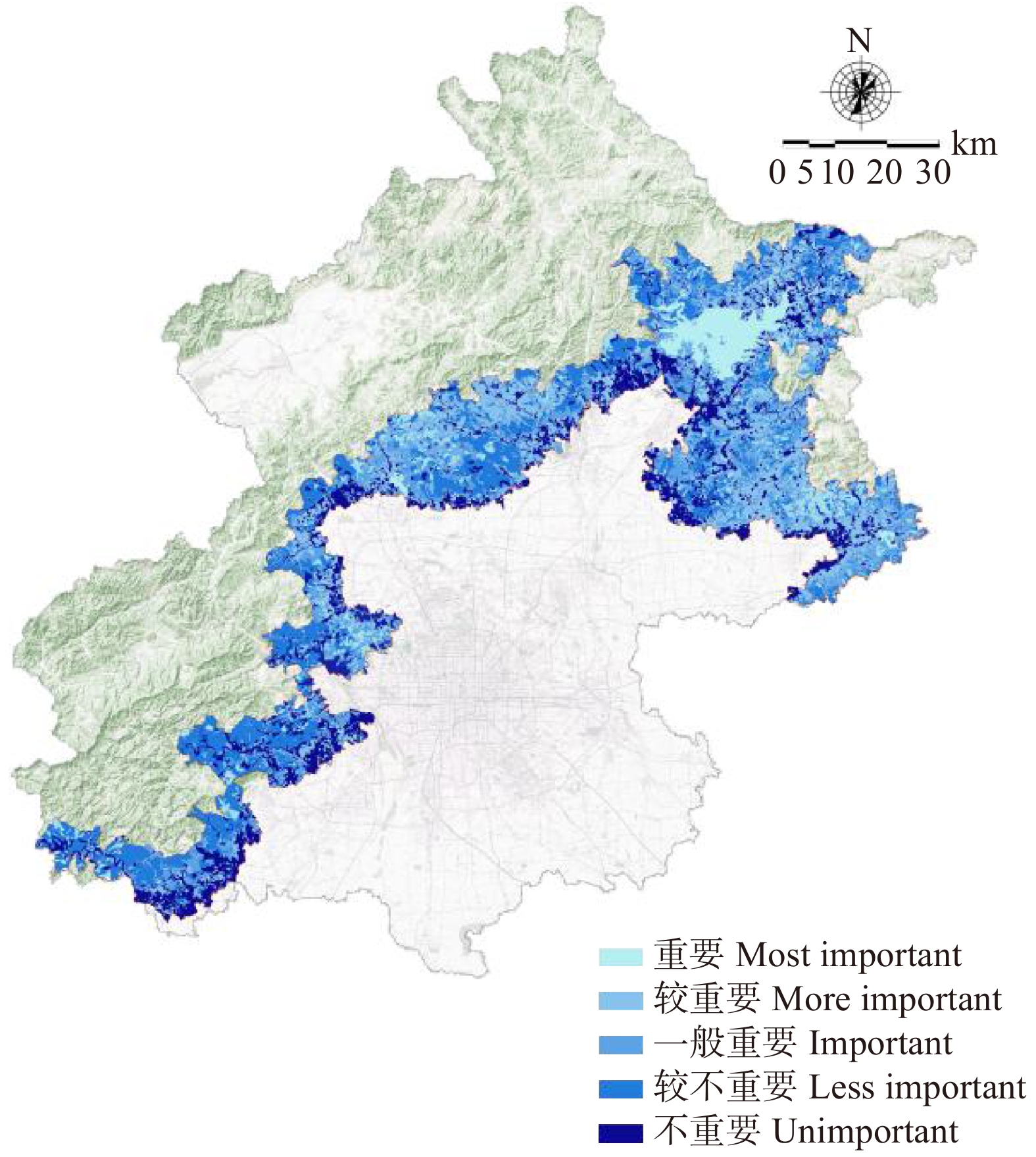
表 2 基于生态系统服务的绿色空间评价指标
Table 2 Green space evaluation indicators based on ecosystem services
服务功能
Ecosystem services功能内涵
Functional connotation指标
Index指标描述
Indicator description绿色空间类型
Types of green space调节服务
Adjustment services生态系统为人类提供诸如维持空气质量、调节气候、控制侵蚀以及净化水源等调节性效益
Regulatory benefits of ecosystem for human beings, including maintaining air quality, regulating climate, controlling erosion, and purifying water source缓解热岛效益
Mitigation of heat island effect低于最热月平均温度
Below the hottest monthly mean temperature森林公园、湿地公园、生态保育绿地
Forest park, wetland park, ecological conservation green space水土保持效益
Water and soil conservation effect计算土壤径流系数进行评价
Calculating runoff coefficient and evaluating固碳释氧效益
Carbon fixation and oxygen release effect年平均固碳释氧量
Average annual carbon sequestration and oxygen release调节气候效益
Climate regulation effect通风潜力大小
Ventilation potential支持服务
Support services生态系统生产和支撑其他服务功能的基础功能
Basic functions of ecosystem production and supporting other service functions保护生物多样性效益
Conservation of biodiversity effect栖息地适宜性评价
Habitat suitability assessment森林公园、湿地公园、生态保育绿地
Forest park, wetland park, ecological conservation green space文化服务
Cultural services通过丰富精神生活、发展认知、休闲娱乐,以及美学欣赏等方式而使人类从生态系统获得的非物质效益
Non-material benefits of mankind from ecosystem, including enriching spiritual life, developing cognition, recreation and entertainment, and aesthetic appreciation, etc娱乐机会
Entertainment opportunities道路可达性
Road accessibility风景名胜区、地质公园、城市公园、郊野公园
Scenic spots, geoparks, urban parks, country parks文化美学效益
Cultural aesthetics effect文化遗产、旅游景区核密度分析
Analysis of nuclear density of cultural heritage and tourist scenic spots注:表2内容来源于参考文献[20]。Note: the contents of Tab. 2 are cited from reference [20].
下载: 导出CSV
表 3 不同植被覆盖类型固碳能力
Table 3 Carbon sequestration capacity of different vegetation cover types
g·d− 1 植被类型
Vegetation
type地上部分单位固碳量
Carbon sequestration per
unit of aerial part地下部分单位固碳量
Underground carbon
sequestration per unit土壤固碳量
Soil carbon
sequestration总固碳量
Total carbon
sequestration单位释氧量
Unit oxygen
release阔叶树 Broadleaf 1.600 0.288 0.93 2.818 1.163 针叶树 Conifer 1.554 0.342 2.63 4.526 1.130 灌木 Shrub 0.970 0.175 0.27 1.415 0.706 草地 Grassland 0.27 0.27
下载: 导出CSV
表 4 评价指标与阈值范围
Table 4 Evaluation indicators and threshold range
指标
Index日均气温差值
Daily mean temperature
difference (Bio2)温度季节变动
Seasonal variation of
temperature (Bio4)最冷季平均温度
Average temperature in
the coldest season (Bio11)坡度
Slope高程
Altitude归一化植被指数Normalized difference vegetation index
(NDVI)阈值 Threshold < 12.25 ℃ < 1 157 < − 2.2 ℃ > 3° > 50 m > 0.43
下载: 导出CSV
表 5 关键绿色空间类型划分
Table 5 Classification of key green space types
生态系统服务功能
Ecosystem service function缓解热岛效应
Mitigation of heat island effect固碳释氧
Carbon fixation and oxygen release通风潜力
Ventilation potential绿色空间类型
Types of green space湿地公园、森林公园
Wetland park, forest park湿地公园、森林公园
Wetland park, forest park湿地公园、森林公园、郊野公园、城市公园
Wetland park, forest park, country park,
urban park生态系统服务功能
Ecosystem service function生物多样性保护
Biodiversity conservation水土保持
Water and soil conservation休闲游憩
Recreation绿色空间类型
Types of green space生态保育绿地、湿地公园、森林公园
Ecological conservation green space, wetland park, forest park生态保育绿地、湿地公园
Ecological conservation green space, wetland park风景名胜区、森林公园、湿地公园、郊野公园、城市公园、地质公园
Scenic spots, forest park, wetland park, country park, urban park, geological park
下载: 导出CSV
表 6 新增绿道长度
Table 6 Length of the newly added greenway
编号 No. 1 2 3 4 5 6 长度 Length/km 46 7 13 11 37 58
下载: 导出CSV
-
[1] Daily G C. Nature’s services: societal dependence on natural ecosystems[M]. Washington: Island Press, 1997.
[2] Capistrano D, Samper C, Lee M J, et al. Ecosystems and human well-being: multiscale assessments: findings of the Sub-global Assessments Working Group of the Millenium Ecosystem Assessment[M]. Washington: Island Press, 2005.
[3] 戴尔阜, 王晓莉, 朱建佳, 等. 生态系统服务权衡: 方法、模型与研究框架[J]. 地理研究, 2016, 35(6):1005−1016. Dai E F, Wang X L, Zhu J J, et al. Methods, tools and research framework of ecosystem service trade-offs[J]. Geographical Research, 2016, 35(6): 1005−1016.
[4] Tallis H, Goldman R, Uhl M, et al. Integrating conservation and development in the field: implementing ecosystem service projects[J]. Frontiers in Ecology and the Environment, 2009, 7(1): 12−20. doi: 10.1890/080012
[5] 郑华, 李屹峰, 欧阳志云, 等. 生态系统服务功能管理研究进展[J]. 生态学报, 2013, 33(3):702−710. Zheng H, Li Y F, Ouyang Z Y, et al. Progress and perspectives of ecosystem services management[J]. Acta Ecologica Sinica, 2013, 33(3): 702−710.
[6] 王军, 顿耀龙. 土地利用变化对生态系统服务的影响研究综述[J]. 长江流域资源与环境, 2015, 24(5):798−808. Wang J, Dun Y L. A review on the effects of land use change on ecosystem services[J]. Resources and Environment in the Yangtze Basin, 2015, 24(5): 798−808.
[7] 吕一河, 张立伟, 王江磊. 生态系统及其服务保护评估: 指标与方法[J]. 应用生态学报, 2013, 24(5):1237−1243. Lü Y H, Zhang L W, Wang J L. Assessment of ecosystem and its services conservation: indicators and methods[J]. Chinese Journal of Applied Ecology, 2013, 24(5): 1237−1243.
[8] 赵士洞, 张永民. 生态系统与人类福祉: 千年生态系统评估的成就、贡献和展望[J]. 地球科学进展, 2006, 21(9):895−902. doi: 10.3321/j.issn:1001-8166.2006.09.002 Zhao S D, Zhang Y M. Ecosystems and human well-being: the achievements, contributions and prospects of the millennium ecosystem assessment[J]. Advances in Earth Science, 2006, 21(9): 895−902. doi: 10.3321/j.issn:1001-8166.2006.09.002
[9] Li T, Cui Y H, Liu A G. Spatiotemporal dynamic analysis of forest ecosystem services using “big data”: a case study of Anhui Province, central-eastern China[J]. Journal of Cleaner Production, 2017, 142: 589−599. doi: 10.1016/j.jclepro.2016.09.118
[10] Derkzen M L, Van Teeffelen A J A, Verburg P H. Review: quantifying urban ecosystem services based on high-resolution data of urban green space: an assessment for Rotterdam, the Netherlands[J]. Journal of Applied Ecology, 2015, 52(4): 1020−1032. doi: 10.1111/1365-2664.12469
[11] 孙强, 蔡运龙, 王乐. 基于土地利用类型的绿色空间生态评估: 以北京市通州区重点新城为例[J]. 中国土地科学, 2007, 21(1):36−42. doi: 10.3969/j.issn.1001-8158.2007.01.006 Sun Q, Cai Y L, Wang L. Land use based ecological assessment of green space: a case study of Tongzhou District of Beijing[J]. China Land Science, 2007, 21(1): 36−42. doi: 10.3969/j.issn.1001-8158.2007.01.006
[12] 顾康康, 程帆, 杨倩倩. 基于GISP模型的城市绿色基础设施多功能性评估[J]. 生态学报, 2018, 38(19):7113−7119. Gu K K, Cheng F, Yang Q Q. Analysis of multifunctional urban green infrastructure using a GISP model[J]. Acta Ecologica Sinica, 2018, 38(19): 7113−7119.
[13] 于丹丹, 吕楠, 傅伯杰. 生物多样性与生态系统服务评估指标与方法[J]. 生态学报, 2017, 37(2):349−357. Yu D D, Lü N, Fu B J. Indicator systems and methods for evaluating biodiversity and ecosystem services[J]. Acta Ecologica Sinica, 2017, 37(2): 349−357.
[14] 陈妍, 乔飞, 江磊. 基于InVEST模型的土地利用格局变化对区域尺度生境质量的评估研究: 以北京为例[J]. 北京大学学报(自然科学版), 2016, 52(3):553−562. Chen Y, Qiao F, Jiang L. Effects of land use pattern change on regional scale habitat quality based on invest model: a case study in Beijing[J]. Acta Scientiarum Naturalium Universitatis Pekinensis, 2016, 52(3): 553−562.
[15] 中国科学院. 地理空间数据云平台[EB/OL]. [2019−01−08] http://www.gscloud.cn/. Chinese Academy of Sciences. Geospatial data cloud platform[EB/OL]. [2019−01−08] http://www.gscloud.cn/.
[16] 国家地理信息测绘局. 国家基础地理信息网站[EB/OL]. [2019−01−08] http://www.ngcc.cn/. National Geographic Information Surveying and Mapping Bureau. National Basic Geographic Information Website[EB/OL]. [2019−01−08] http://www.ngcc.cn/.
[17] 蔡其侃. 北京鸟类志[M]. 北京: 北京出版社, 1988. Cai Q K. Beijing bird records[M]. Beijing: Beijing Publishing Group, 1988.
[18] 李杨, 袁梨, 史洋, 等. 北京地区珍稀鸟类生态分布的GIS分析[J]. 北京林业大学学报, 2015, 37(5):119−125. Li Y, Yuan L, Shi Y, et al. GIS analysis of the distribution dynamics of rare birds in Beijing[J]. Journal of Beijing Forestry University, 2015, 37(5): 119−125.
[19] 李晓京. 北京山区森林鸟类多样性及其保护研究[D]. 北京: 北京林业大学, 2008. Li X J. A study on bird biodiversity and conservation in the mountainous areas in Beijing[D]. Beijing: Beijing Forestry University, 2008.
[20] 谢高地, 张彩霞, 张昌顺, 等. 中国生态系统服务的价值[J]. 资源科学, 2015, 37(9):1740−1746. Xie G D, Zhang C X, Zhang C S, et al. The value of ecosystem services in China[J]. Resources Science, 2015, 37(9): 1740−1746.
[21] 宋挺, 段峥, 刘军志, 等. 基于Landsat-8数据和劈窗算法的地表温度反演及城市热岛效应研究[J]. 环境监控与预警, 2014, 6(5):4−14. doi: 10.3969/j.issn.1674-6732.2014.05.003 Song T, Duan Z, Liu J Z, et al. Land surface temperature retrieval from Landsat-8 data using split-window algorithm and its application on the study of urban heat island effect[J]. Environmental Monitoring and Forewarning, 2014, 6(5): 4−14. doi: 10.3969/j.issn.1674-6732.2014.05.003
[22] 马长欣, 刘建军, 康博文, 等. 1999—2003年陕西省森林生态系统固碳释氧服务功能价值评估[J]. 生态学报, 2010, 30(6):1412−1422. Ma C X, Liu J J, Kang B W, et al. Evaluation of forest ecosystem carbon fixation and oxygen release services in Shaanxi Province from 1999 to 2003[J]. Acta Ecologica Sinica, 2010, 30(6): 1412−1422.
[23] 王梓茜, 程宸, 杨袁慧, 等. 基于多元数据分析的城市通风廊道规划策略研究: 以北京副中心为例[J]. 城市发展研究, 2018, 25(1):87−96. doi: 10.3969/j.issn.1006-3862.2018.01.012 Wang Z X, Cheng C, Yang Y H, et al. Research on urban ventilation channel planning strategy which based on multivariate date analysis: take Beijing sub center as an example[J]. Urban Development Studies, 2018, 25(1): 87−96. doi: 10.3969/j.issn.1006-3862.2018.01.012
[24] 孙庆艳, 余新晓, 杨新兵, 等. 密云水库集水区防护林不同树种林冠截留研究[J]. 中国水土保持科学, 2009, 3(3):73−78. doi: 10.3969/j.issn.1672-3007.2009.03.013 Sun Q Y, Yu X X, Yang X B, et al. Forest canopy interception of different tree species of protection forest in Miyun Reservoir Watershed[J]. Science of Soil and Water Conservation, 2009, 3(3): 73−78. doi: 10.3969/j.issn.1672-3007.2009.03.013
[25] 陈丽华, 张艺, 余新晓, 等. 北京山区典型森林植被林冠截留特征及模拟[J]. 应用基础与工程科学学报, 2013, 21(3):423−431. doi: 10.3969/j.issn.1005-0930.2013.03.004 Chen L H, Zhang Y, Yu X X, et al. Characteristics and simulation on canopy interception of typical forest vegetation in Beijing West Mountain Area[J]. Journal of Basic Science and Engineering, 2013, 21(3): 423−431. doi: 10.3969/j.issn.1005-0930.2013.03.004
[26] 樊登星, 余新晓, 岳永杰, 等. 北京西山不同林分枯落物层持水特性研究[J]. 北京林业大学学报, 2008, 30(增刊 2):177−181. Fan D X, Yu X X, Yue Y J, et al. Water holding characteristics of litter layer of different forest stands in Xishan Mountain in Beijing[J]. Journal of Beijing Forestry University, 2008, 30(Suppl. 2): 177−181.
[27] 张峰, 彭祚登, 安永兴, 等. 北京西山主要造林树种林下枯落物的持水特性[J]. 林业科学, 2010, 46(10):6−14. doi: 10.11707/j.1001-7488.20101002 Zhang F, Peng Z D, An Y X, et al. Water-holding characteristics of the litter under main tree species plantations in Beijing Xishan Mountainous Areas[J]. Scientia Silvae Sinicae, 2010, 46(10): 6−14. doi: 10.11707/j.1001-7488.20101002
[28] 赵人镜, 戈晓宇, 李雄. “留白增绿”背景下北京市栖息生境型城市森林营建策略研究[J]. 北京林业大学学报, 2018, 40(10):102−114. Zhao R J, Ge X Y, Li X. Research on habitat-type urban forest construction strategy in Beijing in the background of “leave blank space and increase green space”[J]. Journal of Beijing Forestry University, 2018, 40(10): 102−114.
[29] 朱耿平, 刘国卿, 卜文俊, 等. 生态位模型的基本原理及其在生物多样性保护中的应用[J]. 生物多样性, 2013, 21(1):90−98. Zhu G P, Liu G Q, Bu W J, et al. Ecological niche modeling and its applications in biodiversity conservation[J]. Biodiversity Science, 2013, 21(1): 90−98.
[30] Merow C, Smith M J, Silander Jr J A. A practical guide to MaxEnt for modeling species’ distributions: what it does, and why inputs and settings matter[J]. Ecography, 2013, 36(10): 1058−1069. doi: 10.1111/j.1600-0587.2013.07872.x
[31] 王健龙, 王红娟. 基于Maxent模型的红腹锦鸡适宜生境分布研究[J]. 安徽林业科技, 2016, 42(1/2):12−15. Wang J L, Wang H J. Research on suitable habitat distribution for Chrysolophus pictus based on the MaxEnt model[J]. Anhui Forestry Science and Technology, 2016, 42(1/2): 12−15.
[32] 王瑶, 宫辉力, 李小娟. 基于最小累计阻力模型的景观通达性分析[J]. 地理空间信息, 2007, 5(4):45−47. doi: 10.3969/j.issn.1672-4623.2007.04.017 Wang Y, Gong H L, Li X J. Analysis of the culture landscape accessibility based on minimum cumulative resistance model[J]. Geospatial Information, 2007, 5(4): 45−47. doi: 10.3969/j.issn.1672-4623.2007.04.017
[33] 李国煜, 林丽群, 伍世代, 等. 生态源地识别与生态安全格局构建研究: 以福建省福清市为例[J]. 地域研究与开发, 2018, 37(3):120−125. Li G Y, Lin L Q, Wu S D, et al. Recognition of ecological source and ecological security pattern construction: a case study of Fuqing City[J]. Areal Research and Development, 2018, 37(3): 120−125.
[34] 王旭东, 陈尧, 陈闪, 等. 基于空间绩效的城镇绿地生态网络构建: 以安徽宣城狸桥为例[J]. 中南林业科技大学学报, 2016, 36(3):87−95. Wang X D, Chen Y, Chen S, et al. Construction of town green land ecological networks based on spatial performance taking Liqiao Town, Xuancheng in Anhui as an example[J]. Journal of Central South University of Forestry & Technology, 2016, 36(3): 87−95.
[35] 郭纪光, 蔡永立, 罗坤, 等. 基于目标种保护的生态廊道构建: 以崇明岛为例[J]. 生态学杂志, 2009, 28(8):1668−1672. Guo J G, Cai Y L, Luo K, et al. Ecological corridor construction based on target species protection: a case study of Chongming Island[J]. Chinese Journal of Ecology, 2009, 28(8): 1668−1672.
[36] 李雄, 张云路. 新时代城市绿色发展的新命题: 公园城市建设的战略与响应[J]. 中国园林, 2018, 34(5):38−43. doi: 10.3969/j.issn.1000-6664.2018.05.008 Li X, Zhang Y L. A new approach in urban green development for the New Era: strategies for building park cities[J]. Chinese Landscape Architecture, 2018, 34(5): 38−43. doi: 10.3969/j.issn.1000-6664.2018.05.008


计量
- 文章访问数: 3334
- HTML全文浏览量: 1375
- PDF下载量: 157
