Construction of ecological corridor in Xishuangbanna Prefecture, Yunnan Province of southwestern China
-
摘要:目的
构建西双版纳州生态廊道网络,针对区域生态保护及修复、生态空间管控和可持续发展、廊道复合型保护提出合理化建议。
方法以西双版纳州为研究对象,运用“生态系统服务—生态敏感性”优化生态源地识别方法,借助最小阻力模型判定生态节点和生态廊道,构建绿色生态网络系统。以生态优先为出发点,划分多级生态空间管控区。
结果研究范围内共构建25条生态廊道,其中重要生态廊道12条。总体上看,全域生态廊道延伸距离较长,但其辐射面积和生态抗性欠佳;重要生态廊道分为三线两类,集中分布在中部和东部区域(分属景洪市和勐腊县);东南部(勐腊县)、西部及西南部分区域(勐海县)廊道覆盖范围较低,生态节点密度和生态连通性均不足,具有较大提升整合空间。
结论西双版纳作为云南省南部边境生态屏障,具有极其突出的生态价值。针对斑块散落、生态廊道断点较多等问题,建议制定复合型管理办法,加快完善生态补偿机制,对廊道网络进行统筹管理和调节,促进生态廊道的可持续发展。
Abstract:ObjectiveThis paper constructs an ecological corridor network in Xishuangbanna Prefecture, Yunnan Province of southwestern China and puts forward rational suggestions for regional ecological protection and restoration, ecological space management and sustainable development, and corridor composite protection.
MethodTaking Xishuangbanna Prefecture as the research object, the method of “ecosystem services-ecological sensitivity” was adopted to optimize the identification of ecological source, and the minimum cumulative resistance model (“MCR Model”) was adopted to determine ecological nodes and ecological corridors. A green ecological network system was established. And taking ecological conservation as the key task, multi-level ecological space management and control areas were classified.
Result25 ecological corridors were established within the research scope, therein 12 important ecological corridors were included. In general, the ecological corridors of whole region extended a long distance, but their radiation area and ecological resistance were poor; important ecological corridors were divided into three lines and two types, concentrated in the central and eastern regions (belonging to Jinghong City and Mengla County, respectively); the coverage of corridor was low in the southeastern (Mengla County), western and southwestern parts (Menghai County), the ecological node density and ecological connectivity were insufficient. Thus, there was a large space for improvement and integration.
ConclusionXishuangbanna, as an ecological barrier on the southern border of Yunnan Province, has extremely outstanding ecological value. In response to issues such as scattered patches and multiple breakpoints in ecological corridors, it is recommended to develop a comprehensive management approach from multiple perspectives, accelerate the improvement of ecological compensation mechanisms, coordinate and regulate the corridor network, and promote the sustainable development of ecological corridors.
-
生态网络是在特定尺度空间内连接生态源地,识别线性生态廊道,反映空间组织结构与景观结构特征的空间组织体系。生态网络的研究,旨在探究生态系统中物种之间的相互作用关系和物种群落的结构和功能[1]。生态网络的构建,对增加生态系统结构的连接性和稳定性、生物多样性保护和自然资源合理利用均具有积极作用。伴随城市快速扩张,生态廊道的环境承载和控制压力日渐突出。如何在确保生态效益的同时兼顾区域发展,成为当前面临的重要挑战。
西双版纳州生态环境优越,拥有中国目前保存较为完整的、面积最大的热带雨林,是重要的物种基因库,在生物物种保护等方面具有重要作用。据2013年数据统计,云南省的热带雨林面积为420 337 hm2,其中勐腊县分布最多,达120 920 hm2。尽管自1958年以来,西双版纳州已开展了各种形式的重点保护,但目前得到保护的雨林仅占西双版纳热带雨林总面积的50%,且零星分布在大面积退化生境中,呈岛状分布。《云南省国土空间规划(2021—2025年)》提出,需着力构建“三屏两带六廊多点”的生态安全格局,守护自然生态安全底线,提升重点生态系统功能,全面实施生态保护与修复。加强斑块联系,保护现有生境,构建区域完整生态廊道系统已迫在眉睫。
本研究基于已有成果,将研究区域视为一个有机生态主体,基于“生态系统服务—生态敏感性”识别生态源地,利用最小阻力模型判定生态廊道和生态节点。以期从优化地区生态格局角度提高生态系统效能,提升生态栖息地、整合绿地斑块等目标,为西双版纳州生态格局建设提供可持续发展的框架。
1. 研究区域概况
1.1 自然地理情况
西双版纳傣族自治州(21°10′ ~ 22°40′N、99°55′ ~ 105°50′E)位于中国西南边陲,辖1个县级市(景洪市)和2个县(勐腊县、勐海县),总占地面积为19 124.5 km2,属热带季风气候,终年温暖湿润。其州域及周边风景游憩、地质矿产、动植物等资源较为丰富,有我国最完整的热带生态系统,可提供较多的生态服务,在西南地区乃至全国的生态地位都十分重要[2]。
1.2 数据来源
本研究所用数据有:西双版纳州土地利用数据(2020年)、数字高程模型、土壤数据、月平均降水数据(2020年)、植被覆盖指数(2020年)、西双版纳州自然保护区范围。所有数据像元大小均为30 m × 30 m,空间坐标系统一为WGS_1984_UTM_Zone_47N,其他数据来源等信息见表1。
表 1 研究数据来源Table 1. Research data sources数据
Data数据精度
Data accuracy数据来源
Data source土地利用数据 Land use data 30 m × 30 m 遥感数据解译 Remote sensing data interpretation 数字高程模型 Digital elevation model 30 m × 30 m 中国科学院地理空间数据云平台
Chinese Academy of Sciences geospatial data cloud platform (http://www.gscloud.cn/)月平均降水数据 Average monthly rainfall data 国家科技基础条件平台—国家地球系统科学数据中心
National Earth System Science Data Center (http://www.geodata.cn)植被覆盖指数 Vegetation coverage index 土壤数据 Soil data 1∶ 1000 000世界粮农组织统一的世界土壤数据库 FAO unified world soil database 西双版纳州自然保护区范围
Nature Reserve scope of Xishuangbanna Prefecture中国自然保护区标本资源共享平台
China Nature Reserve Specimen Resource Sharing Platform2. 研究方法
2.1 生态源地选取
生态源地是指现存的各类物种栖息地以及其他能够提供生态功能的斑块,其在区域生态安全中具有重要意义或者担负重要辐射功能[3]。基于“生态系统服务—生态敏感性”优化生态源地选择,旨在从多角度识别生态重要区域。生态系统服务侧重对已有生态价值斑块的筛选,生态敏感性重点考察生态过程对环境变化的响应。利用冷热点分析工具提取备选源地,通过取并集确定综合热点生态源地。根据《生态保护红线划定指南》要求,同时考虑当地濒危动物,如印度野牛(Bos gaurus)、亚洲象(Elephas maximus)、绿孔雀(Pavo muticus)等的栖息地保护要求[4],确定面积大于50 m2的源地作为重要生态源地。
2.1.1 生态系统服务评价体系
生态系统服务是指生态系统与生态过程中所形成的及所维持的人类赖以生存的自然环境条件与效用[5],其重要性评价结果可以为生态系统管理与生态保护和建设提供依据[6]。利用INVEST模型中水源涵养模块、土壤保持模块和生境质量模块对西双版纳州水源涵养、土壤保持和生境质量3个因子进行计算。归一化处理后,采用自然间断点法将3个生态因子分为5级。
(1)水源涵养模块:利用产水模型,基于土地利用类型、降水量等数据根据年降水量和Budyko曲线进行估算[7],再用产水量减去地表径流量得到单位栅格水源涵养量[8],计算公式为
Yxj=(1−ExjPx) Px (1) 式中:Yxj 表示在土地类型j上栅格x年水源供给量(mm),Exj表示栅格x中土地利用类型j的年实际蒸散发量(mm),Px表示栅格x的年降水量(mm)。
(2)土壤保持模块:使用通用土壤流失方程,分别计算潜在土壤侵蚀量(Ap)和实际土壤侵蚀量(Ar),两者之差即为土壤保持量(Ac)[9],计算公式为
Ar=R K LS C P (2) Ap=R K LS (3) Ac=Ap−Ar (4) 式中:R为降水侵蚀力因子(MJ·mm/(hm2·h·a)),K为土壤可蚀性因子(t·hm2·h/(hm2·MJ·mm)),LS为坡长坡度因子,C为植被经营管理因子,P为土壤保持措施因子。
(3)生境质量模块:生境质量的高低受到胁迫因子影响距离、生境与胁迫因子距离、生境敏感性及每个单元受到的保护水平[10],计算公式为
Dxj=N∑r−1Yr∑y−1(WrN∑y−1Wr)ry irxy βx Sjr (5) 式中:Dxj为j土地类型生态系统中栅格x的生境退化程度;N表示威胁因子的数量;r为胁迫因子;Yr是胁迫因子r在地类层上的栅格数量;Wr为r胁迫因子的相对权重;ry表示土地利用类型中y栅格上胁迫因子的数量;irxy为r类型胁迫源图层中y栅格对生态系统栅格x的影响强度,也是生境与胁迫因子之间的距离函数,取值范围为0 ~ 1;βx为栅格x的抗干扰能力,具体可以分为线性和指数两种作用;Sjr代表土地类型j对于胁迫因子r的敏感性。
基于生境退化度,计算生境质量程度,计算公式为
Qxj=Hj{1−(DzxjDzxj+kz)} (6) 式中:Qxj是地类j中栅格x的生境质量;Hj表示土地类型j的生境适宜性;Dxj是地类j中栅格x的生境退化水平;k为半饱和参数,通常取Dxj最大值的一半,Z为归一化常量,通常取2.5。通过参考同类型研究文章以及INVEST官方使用手册,确定相关胁迫因子及赋值(表2)。
表 2 生境质量胁迫因子赋值Table 2. Assignment of habitat quality stress factors胁迫因子
Stress factor最大距离
Max.
distance/km权重
Weight空间衰减类型
Spatial attenuation type水田 Paddy field 5 0.7 指数 Exponential 旱地 Dry land 10 0.8 指数 Exponential 城镇 Urban area 15 1 线性 Linear 乡村 Rural area 10 0.9 线性 Linear 铁路 Railway 8 0.6 指数 Exponential 道路(城镇)
Road (urban area)7 0.5 指数 Exponential 基于研究区土壤保持、水源涵养、生境质量3类生态系统服务功能计算结果,进行权重叠加,形成生态系统服务功能重要性评价结果。通过层次分析法确定指标权重,3个因子的权重分别为土壤保持(0.163)、水源涵养(0.297)和生境质量(0.540)。一致性比率(CR) = 0.009 < 0.1,通过一致性检验,计算叠加后得到综合生态系统服务评价图。运用自然断点法将评价结果划分为极重要区、高等重要区、中等重要区、较重要区、一般重要区,形成西双版纳州生态系统服务总体空间格局。
2.1.2 生态敏感性评价体系
生态敏感性是评价生态系统稳定性的重要标准之一,能够反映出区域生态受到干扰后,诱发环境问题和被破坏的难易程度[11−13]。结合西双版纳州资源特征,综合考虑雨林与周边地理环境,兼顾自然与人为活动影响,从自然因素、环境因素和发展控制条件3方面进行指标筛选。
选取高程、坡度、坡向、土地利用类型、归一化植被指数以及距自然保护区的远近程度6个因子进行敏感性指标评价(表3),通过层次分析法确定每个因子的权重,CR =
0.022 < 0.1,通过一致性验证。结合文献[12],归一化处理后以自然间断点法将综合生态敏感性计算结果由低至高分为5个等级。表 3 生态敏感性等级划分Table 3. Level classification of ecological sensitivity评价因子
Evaluation factor生态敏感性等级 Ecological sensitivity level 权重
Weight低 Lower 较低 Low 一般 General 较高 High 高 Higher 高程 Elevation/m 369 ~ 819 819 ~ 1 057 1 057 ~ 1 289 1 289 ~ 1 568 1 568 ~ 2 404 0.120 坡度 Slope/(°) 0 ~ 5° 5° ~ 15° 15° ~ 25° 25° ~ 35° > 35° 0.120 坡向 Aspect 南、平面
South, plane东南、西南
Southeast, southwest东、西
South,west东北、西北
Northeast, northwest北
North0.120 植被覆盖指数
Vegetation coverage index−0.20 ~ 0.07 0.08 ~ 0.43 0.44 ~ 0.62 0.63 ~ 0.74 0.75 ~ 0.90 0.078 土地利用类型
Land use type建设用地、未利用地
Construction land, unused land耕地
Farmland草地
Grassland水域
Waters林地
Forestland0.369 距自然保护区的距离
Distance nature conservation
length of zone/m> 2 000 1 000 ~ 2 000 500 ~ 1 000 200 ~ 500 < 200 0.193 2.2 生态廊道构建
2.2.1 阻力面选取
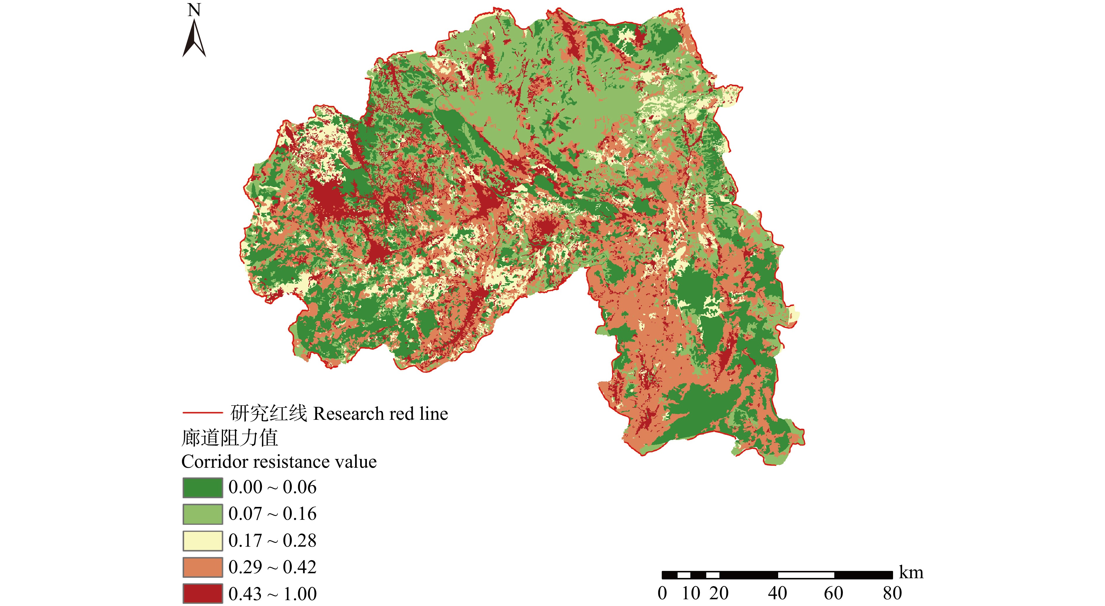
阻力面是反映物种在不同景观单元中迁移所受的阻力大小,传统研究中多以土地利用类型为主要因子来分配阻力值,其局限性在于无法描述相同地类下的内部差异。根据朱琪等[14]、赵月帅等[15]、郑群明等[16]、殷炳超等[17]的研究发现:生境质量与区域生物多样性、物种移动速度成正相关,因此可选用生境质量的相反面,作为生态廊道划定的阻力值(图1)。
2.2.2 生态廊道提取
依据本文2.1章节计算得到的生态源地和阻力值,构建各个源地间的最小成本路径,利用重力模型筛选潜在生态廊道。重力模型最早多应用于交通领域,后逐渐被引用到景观生态中。通过描述各个源地斑块间相互作用力的大小,识别出较为重要的生态廊道。作用力大小与生态引力值呈正相关,模型公式[14]如下
Gim=NiNmD2im=[1PilnSi][1PmlnSm](LimLmax (7) 式中:i和m为两个不同的斑块,Gim为i与m之间的生态引力值,Ni和Nm为其权重,Dim为i与m间廊道阻力标准值,Pi和Pm代表阻力值,Si和Sm代表面积,Lim为累积阻力值,Lmax为最大阻力值。
生态斑块相互作用力越强,廊道建设的必要性及生态效益越显著(见附表1),因此将重力模型计算矩阵中高作用力的廊道定义为重要生态廊道,将其余的廊道划归为一般性生态廊道。
2.2.3 生态节点判定
生态节点作为生态廊道中功能最薄弱的环节[18],对能量的流动起到重要作用,同时在廊道系统中可以很好地增加景观连接度,而道路交通网络对生态廊道的连续性破环较大,易形成断裂点阻碍物种交流。关于生态节点的识别和选择,本文通过提取西双版纳州重要交通网络(铁路、公路、国道、主要城市道路)与已有生态廊道进行叠加,识别生态断点,并依据生态环境特征、已有项目建设情况以及未来发展趋向[6],将其分为生态型节点和重点关注型节点两个部分。
生态型节点:(1)在自然保护区中,因面积破碎未能成为生态源地的斑块,定为一类生态型节点;(2)在一般生态源地中,选取空间位置突出、生态效益优越、面积在0.1 ~ 1.0 km2的生态斑块与生态廊道相交产生的节点,以节点为中心,形成0.1 km2的缓冲区,定为二类生态节点。
重点关注型节点:(1)重要交通网络与重要生态廊道交叉产生的生态断点中,区位优势显著、自然环境优越,所在区域未来规划发展或保护潜力较大的部分,定为一类重点关注型节点;(2)重要生态廊道之间的交叉点作为二类重点关注型节点。
3. 结果与分析
3.1 生态源地识别
3.1.1 生态系统服务评价分析
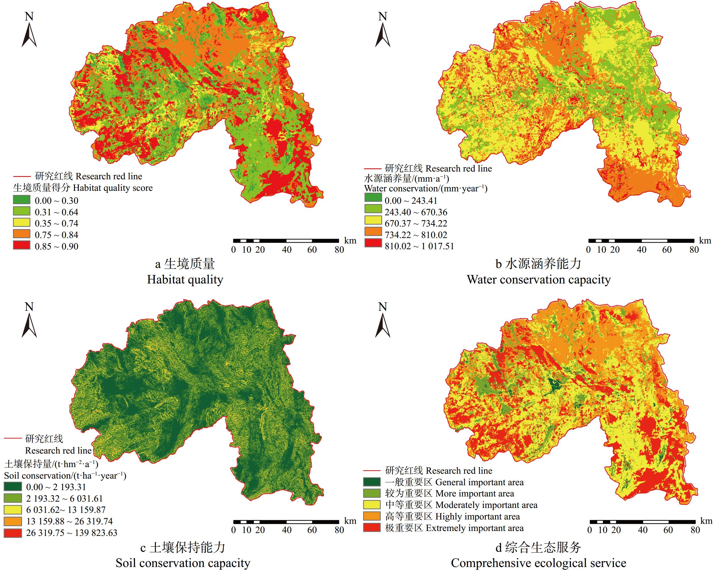
西双版纳州生境质量平均值为0.76,整体生境质量较高,其中高等级区域面积占比20.6%,较高等级区域面积占比21.2%。在空间上主要集中在勐腊县北部、中部及东南部的林地片区;景洪市北部以及勐海县西南部有林地区域(图2a)。水源涵养方面,区域整体属于中等偏上等级。由于当地水热条件和气候优势,水源涵养能力较强,但涵养能力高等级区域分布破碎,较高等级重要区域主要分布在景洪市北部及南部部分地区,勐腊县南部地区,勐海县则以中等级别为主(图2b)。土壤保持方面,区域整体水平较低,空间分布多位于地势低平的城市建设用地,人为活动和建设程度越高,土壤保持水平越低(图2c)。城市边缘地区由于热带雨林的减少,导致水土流失问题严重,亟待采取相应措施进行生态修复。利用层次分析法确定的指标权重,将3个因子进行叠加分析得到综合生态系统服务评价图(图2d)。
3.1.2 生态敏感性评价分析
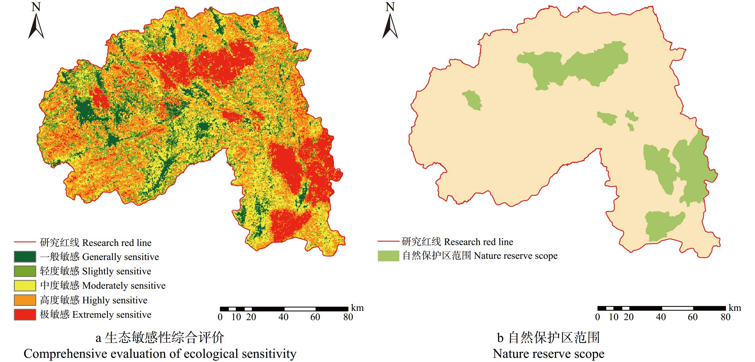
依据表3中权重进行叠加计算,得到生态敏感性综合评价结果(图3a),西双版纳州生态敏感性均值为3.354。其中敏感性高值区域与自然保护区范围重合率较高(图3b)。片区内以热带雨林为主,具有高植被覆盖度、较高海拔等自然特征;而地势平坦开阔,建设程度越高的地区,生态敏感性越低,并随着人为干扰强度增大而减弱。
3.1.3 生态源地筛选
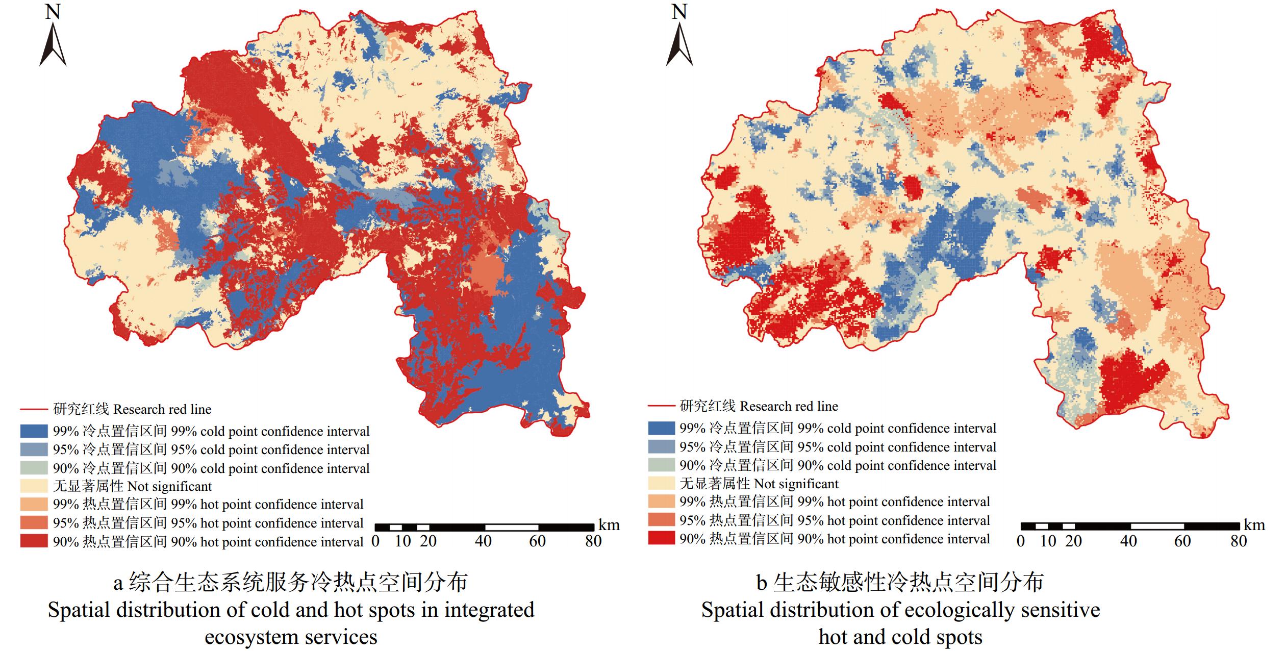
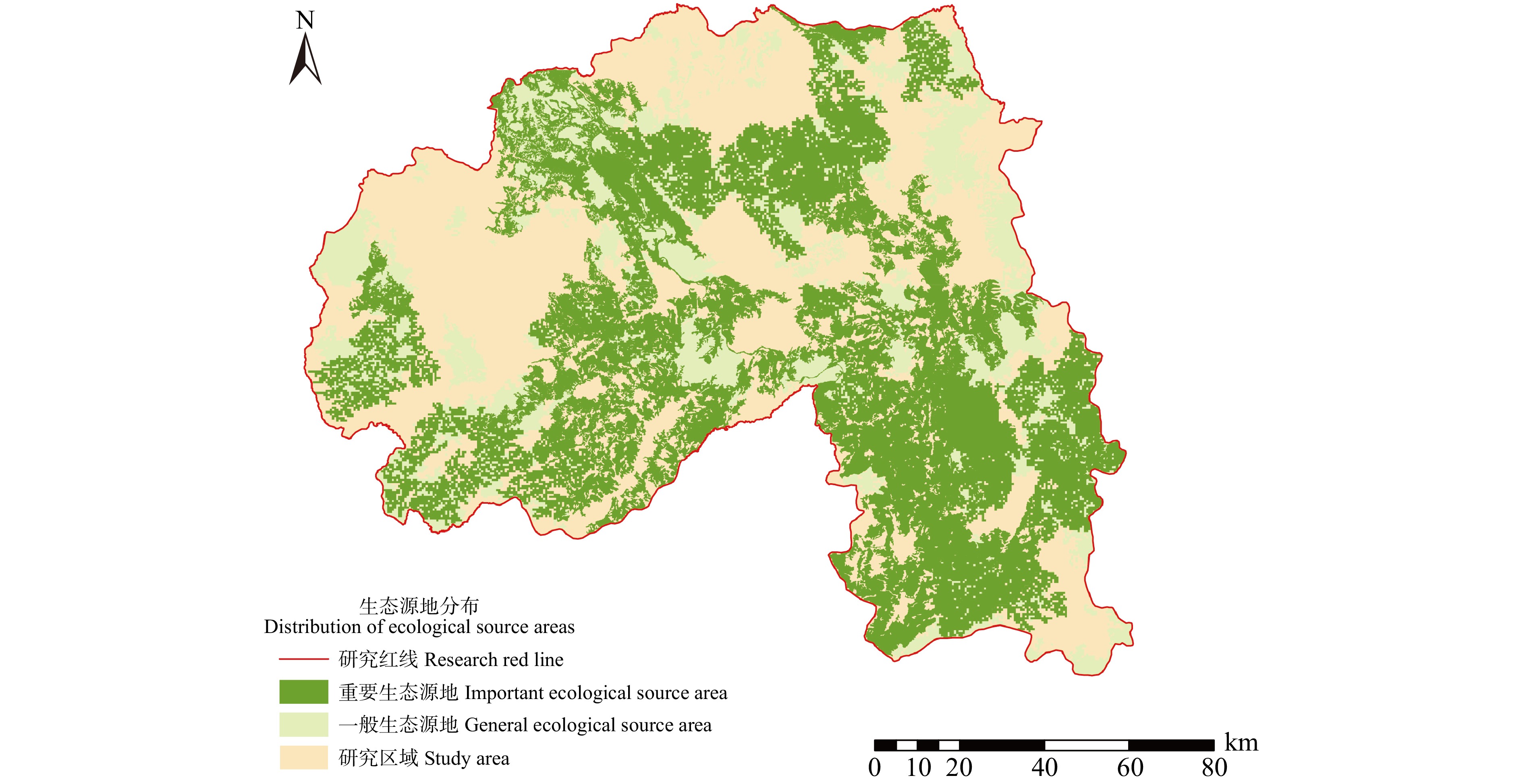
利用GIS平台中Getis-Ord Gi*统计指数,对生态敏感性和生态系统综合服务进行分析,通过对各要素之间Z值和P值的计算,来反映高值(热点)和低值(冷点)要素在空间中聚类的位置(图4)。依据计算结果,对90%及以上可信度区域进行提取,总面积为13 128.66 km2,占总区域面积的68.65%,筛选面积大于50.00 km2的斑块,得到最终生态源地25个(图5),总面积为8 797 .01 km2,其中自然保护区范围内面积为2 702.25 km2。将现有自然保护区位置进行叠加验证,重合率为94.36%,表明本研究筛选结论较为合理。
3.2 生态廊道及生态节点筛选
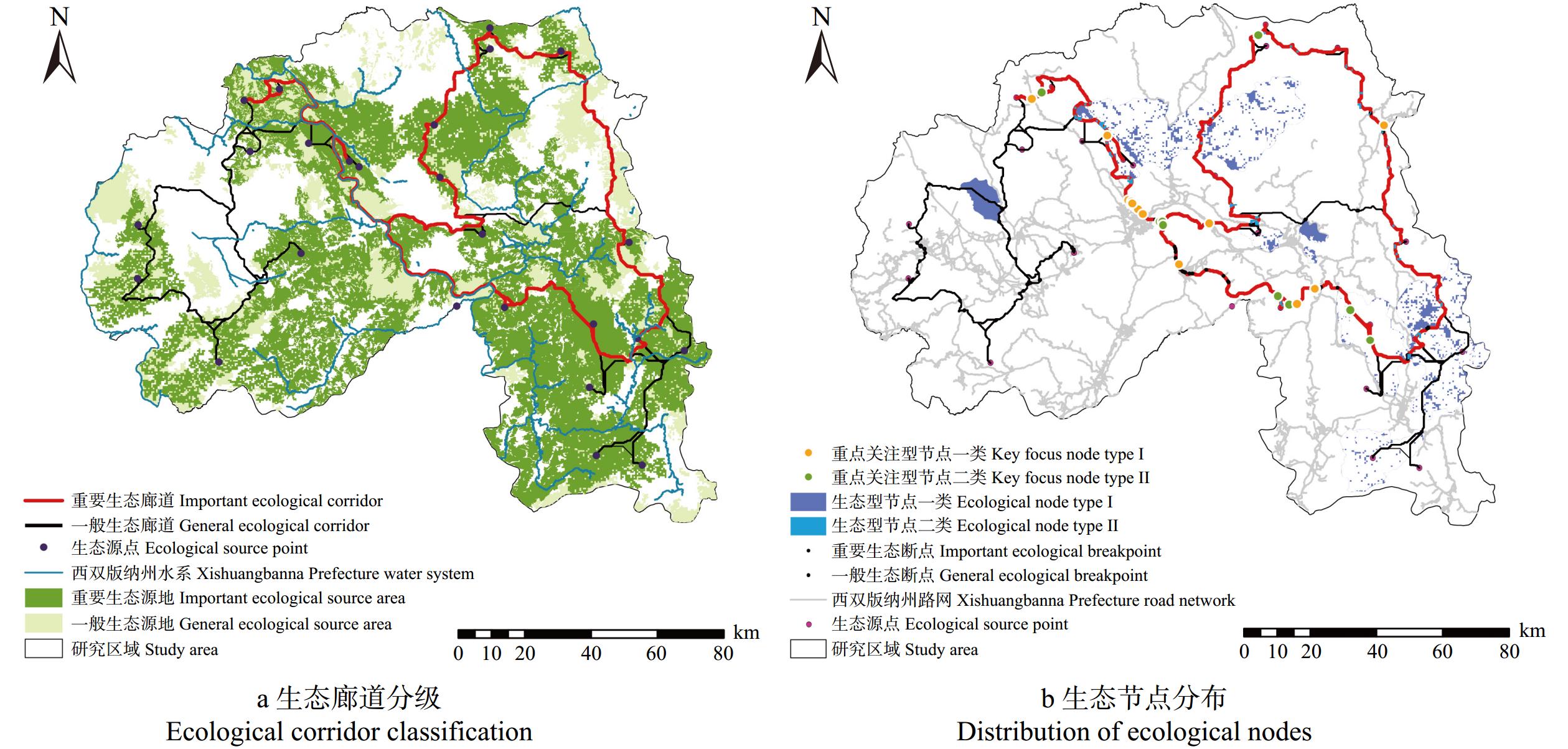
基于重力模型对生态廊道进行提取,共得到25条潜在廊道,通过矩阵计算得到重要生态廊道12条(多条廊道路径重合),总长度为1 218.69 km,一般性生态廊道13条(图6a)。重要生态廊道主要分为三线两类:一线沿澜沧江分布,主要为流域型生态廊道,与《云南省国土空间规划(2021—2025年)》中提出的“普洱–西双版纳生物多样性保护廊道”高度重合;一线沿西双版纳州东侧山脉山脊布设,主要为森林型生态廊道;另一线沿昆磨高速东侧山体分布,同样为森林型生态廊道。首先,西双版纳州生态廊道延伸距离较长,空间分布较为均匀,但重要生态廊道多集中在东侧及东南侧,廊道未能扩散至整个研究区域,生态流动性不足。其次,研究区域内整体廊道分布密度单一,覆盖面积和生态抗性不足。
通过生态廊道与重要交通网络进行叠加分析得到生态断点共计95个,其中与重要生态廊道交叉产生断点53个、一般性生态廊道交叉产生断点42个(图6b)。依据上文2.2.3部分提出的分类原则进行筛选,得到生态型一类节点7个、生态型二类节点39个,重点关注型一类节点13个、二类节点10个。上述两类生态节点均是生态廊道中较为重要、脆弱、易受破坏、易影响物质能量流通的区域[15]。其中勐海县生态型节点位于北侧热带雨林内,面积较为集中;景洪市生态型节点集中于北侧自然保护区周围;勐腊县则较为分散,主要分布在西北侧西双版纳热带植物园附近及东南侧山林地区。重点关注型节点主要分布在铁路、昆磨高速、勐绿高速、G219等与重要生态廊道交叉产生的生态断点上,以及自北向南的澜沧江沿线。
3.3 生态格局分级及管控措施
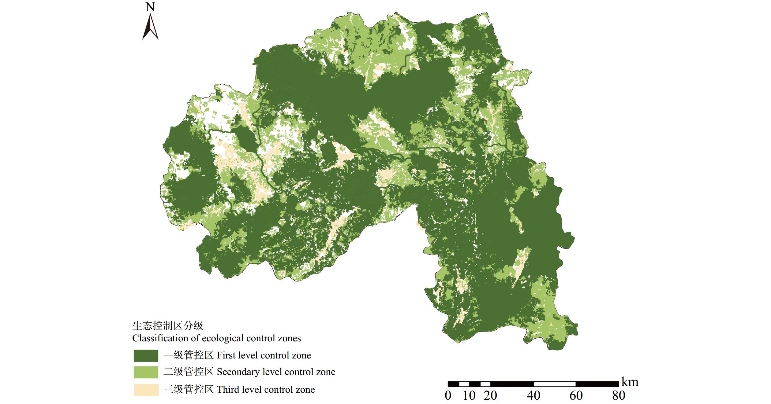
依据生态廊道分级计算结果,以生态保育为重点工作,对西双版纳州进行生态控制区划分,共划分为3个等级(图7)。
一级管控区主要为热带雨林自然系统为代表的生态源地,是区域生态格局的重要位置,包括了生态源地、生态廊道和生态节点,总面积约占51.91%。该管控区域内应严格遵守生态保护红线,减少人工建设对雨林核心区域的干扰,对已建自然保护区加大投资力度,改善区域保护和管理水平;对相对面积较小的区域划定保护点,由相邻村委会、国家级自然保护区或省市林业厅局直接管理。同时依据廊道类型、地形地貌、植被分布状况及区划情况,划建生态廊道,从而有利于野生动植物在这些斑块之间运动,提高廊道间的连接度。
二级管控区为除去城市规划区范围,多数分布在城乡结合区域的绿地,以及西双版纳州内其余林地斑块,总面积约占27.52%。该管控区域内应明确生产生活布局范围和建设规模,以保护生态环境和自然资源为前提,鼓励在自然基础条件和交通系统较好的区域建设小型城郊森林公园或湿地。依据地理位置划定主管单位,明确管辖范围和管理内容。同时加快推进林相改造、完善各类基础设施,扩大生态宣教范围,呼吁更多人加入到生态保护的队伍中。
三级管控区分为两部分:第一类已纳入城市建设范围内,但未进行建设或建设强度较小的绿地;第二类是在热带雨林分布区内,部分村镇所属的绿地,总面积约占4.55%。城市建设范围内的绿地,应完善区域水系及道路交通建设,串联小型绿地斑块,加强绿道体系覆盖和延伸。大力推动城市更新,加快推进城镇棚户区和老旧小区改造。针对位于热带雨林分布区的部分村镇,在有效保护热带雨林的前提下,合理利用热带雨林分布区气候和物种多样性优势,发展珍稀树种培育、热带特产培育等项目,建设可持续经营示范基地,带动和推广可持续经营。同时推进社区或村镇共管工程,完善巡护体系和后勤保障建设,激发村民共建共护的积极性。
4. 结论与讨论
4.1 结 论
本文以生态系统服务与生态敏感性共同确定生态源地,运用最小阻力模型构建西双版纳州生态廊道,进而提出生态格局优化方案。研究发现:(1)西双版纳地区生态源地共计25个,覆盖面积较广,自然本底优越,南部、东南部沿线生态屏障作用突出,北部则主要集中在自然保护区内。(2)重要生态廊道分为三线两类,集中分布在景洪市和勐腊县,总长度为1 218.69 km。而勐海县廊道覆盖范围较低,具有较大的提升整合空间。(3)生态类节点共计46个,主要以林地为主,节点聚集性分布明显;重点关注型节点共计23个,多为已建道路与廊道产生的生态断点。(4)西双版纳地区作为云南省南部边境生态屏障,具有极其突出的生态价值。
4.2 讨 论
4.2.1 指标完善及综合计算
最小阻力模型在大多数物种迁徙和能量流动中,具有较好的适用性[19]。但是,本次阻力面数据是以生境质量的相反面数值进行计算(范围为(0,1)),由于阻力值过小,可能存在对比效果不显著的问题,造成个别破碎生态源地之间无法进行廊道识别。同时对比当前普遍以土地利用、高程等因子进行叠加获得阻力面的方式,本次阻力面选择虽具有地区特征性,但后期缺乏细节矫正。
4.2.2 生态廊道划定及联通性
生态廊道的宽度对区域生态功能表达具有重要作用。当廊道宽度大于12 m时,廊道空间才可以发挥其生物多样性保护的生态效益;宽度在60 m左右时可满足廊道中最基本的生态过程发生;宽度在600 ~ 1 200 m之间时,可维持较大尺度区域的景观安全格局,形成丰富、安全、稳定的景观结构,并满足中、大型哺乳动物迁移通道要求,从而达到保护物种多样性的作用[20−21]。考虑到廊道“边缘效应”,廊道的宽度设置也不应一概而论,有必要通过制定一套精细化的保留与调出规则,人为修正生态廊道的边界与宽度[22]。
生物多样性是生态廊道宽度的主要决定因素[23]。但由于廊道长度的延展,其沿线小环境易受到地形地貌、水体林木以及周边村镇建设的影响,使得热带雨林孤岛化现象日益严重,对野生动物的迁徙、扩散、种群交流十分不利。本研究结合现状条件,构建完整的连接系统,着力提升自然保护区之间的生态联通性。文中得到的重要型生态节点,多为已建成道路(铁路)与林地、水系廊道产生的阻断。针对这种问题,应对重要型生态节点进行特殊管控、处理与利用,如采取生物天桥或地下涵洞的形式保障廊道的完整性;同时以节点为核心设置缓冲区,通过扩大自然面积来提高节点的生态抗性。其次,少数区域由于农业用地和农业生产对廊道产生的阻断,针对此类应完善生态补偿机制,进行统筹管理和调节。
4.2.3 管理及调节机制
生态廊道的管理和调节,也是实现廊道生态效益的重要一环。由于研究范围内生态廊道涉及的地理范围较广,跨越自然斑块较多,易受到自然环境变化和生产生活影响,因此需从多个角度制定复合型管理办法,保障廊道的连续性和生态性。
(1)认真执行《云南省森林生态效益补偿基金管理实施细则》等相关规定,提高资源保护强度,增强全民保护意识,减少廊道沿线村镇居民生产生活对自然生态环境的影响。
(2)政府及相关部门应积极开展农业技能培训、考察,定期邀请专家进行现场讲解示范,提高村民对外部市场的了解,提升村民开展多样化特色农林经营的能力。合理利用自然资源发展经济,构建以经济发展促进生态建设的农业生产经营模式。
(3)以已公布的各类规划为依据,科学引导廊道内的土地利用模式,最大限度恢复和维持生物多样性,充分发挥廊道生态功能。同时通过发展空间和主导产业的合理布局,激活廊道潜在的经济和社会价值,通过细致的调控与积极的导向,促进城市生态廊道的可持续发展。
(4)探索周边临近县市之间利益分配和调节机制,对廊道进行生态功能分区和保护强度分级,实现廊道的分段共管。
(5)促进跨境联合保护,依据《中老跨境联合保护区域亚洲象保护规划》[24]要求,积极从优化保护空间格局、提升双边保护管理水平、建立长远合作3个层面进行合作和推动。
附表1数据详见http://j.bjfu.edu.cn/article/doi/10.12171/j.1000-1522.20230260。
-
表 1 研究数据来源
Table 1 Research data sources
数据
Data数据精度
Data accuracy数据来源
Data source土地利用数据 Land use data 30 m × 30 m 遥感数据解译 Remote sensing data interpretation 数字高程模型 Digital elevation model 30 m × 30 m 中国科学院地理空间数据云平台
Chinese Academy of Sciences geospatial data cloud platform (http://www.gscloud.cn/)月平均降水数据 Average monthly rainfall data 国家科技基础条件平台—国家地球系统科学数据中心
National Earth System Science Data Center (http://www.geodata.cn)植被覆盖指数 Vegetation coverage index 土壤数据 Soil data 1∶ 1000 000世界粮农组织统一的世界土壤数据库 FAO unified world soil database 西双版纳州自然保护区范围
Nature Reserve scope of Xishuangbanna Prefecture中国自然保护区标本资源共享平台
China Nature Reserve Specimen Resource Sharing Platform表 2 生境质量胁迫因子赋值
Table 2 Assignment of habitat quality stress factors
胁迫因子
Stress factor最大距离
Max.
distance/km权重
Weight空间衰减类型
Spatial attenuation type水田 Paddy field 5 0.7 指数 Exponential 旱地 Dry land 10 0.8 指数 Exponential 城镇 Urban area 15 1 线性 Linear 乡村 Rural area 10 0.9 线性 Linear 铁路 Railway 8 0.6 指数 Exponential 道路(城镇)
Road (urban area)7 0.5 指数 Exponential 表 3 生态敏感性等级划分
Table 3 Level classification of ecological sensitivity
评价因子
Evaluation factor生态敏感性等级 Ecological sensitivity level 权重
Weight低 Lower 较低 Low 一般 General 较高 High 高 Higher 高程 Elevation/m 369 ~ 819 819 ~ 1 057 1 057 ~ 1 289 1 289 ~ 1 568 1 568 ~ 2 404 0.120 坡度 Slope/(°) 0 ~ 5° 5° ~ 15° 15° ~ 25° 25° ~ 35° > 35° 0.120 坡向 Aspect 南、平面
South, plane东南、西南
Southeast, southwest东、西
South,west东北、西北
Northeast, northwest北
North0.120 植被覆盖指数
Vegetation coverage index−0.20 ~ 0.07 0.08 ~ 0.43 0.44 ~ 0.62 0.63 ~ 0.74 0.75 ~ 0.90 0.078 土地利用类型
Land use type建设用地、未利用地
Construction land, unused land耕地
Farmland草地
Grassland水域
Waters林地
Forestland0.369 距自然保护区的距离
Distance nature conservation
length of zone/m> 2 000 1 000 ~ 2 000 500 ~ 1 000 200 ~ 500 < 200 0.193 -
[1] 刘庆豪. 山东省会经济圈景观格局时空演变及全要素生态网络构建与分析[D]. 济南: 山东建筑大学, 2023. Liu Q H. Spatial and temporal evolution of landscape pattern andconstruction and analysis ofall-factor ecological network in Shandong provincial capital economie circle[D]. Ji’nan: Shandong Jianzhu University, 2023.
[2] Huang Z D, Bai Y, Alatalo J M, et al. Mapping biodiversity conservation priorities for protected areas: a case study in Xishuangbanna tropical area China[J]. Biological Conservation, 2020, 249: 108741.
[3] 毛诚瑞, 代力民, 齐麟, 等. 基于生态系统服务的流域生态安全格局构建: 以辽宁省辽河流域为例[J]. 生态学报, 2020, 40(18): 6486−6494. Mao C R, Dai L M, Qi L, et al. Constructing ecological security pattern based on ecosystem services: a case study in Liaohe River Basin, Liaoning Province, China[J]. Acta Ecologica Sinica, 2020, 40(18): 6486−6494.
[4] 沈润, 史正涛, 何光熊, 等. 基于景观破碎化指数的西双版纳生态安全格局构建与优化[J]. 热带地理, 2022, 42(8): 1363−1375. Shen R, Shi Z T, He G X, et al. Construction and otimization of the ecological security pattern of Xishuanabanna based on Fraamentation index[J]. Tropical Geography, 2022, 42(8): 1363−1375.
[5] 蒋榕. 基于生态系统服务评估的植物园规划设计[D]. 北京: 北京林业大学, 2021. Jiang R. Planning and design of botanical gardens based on ecosystem service evaluation: a case study of the botanical garden in Yueyang City, Hunan Province[J]. Beijing: Beijing Forestry University, 2021.
[6] 刘学, 杨春艳, 高艳妮, 等. 厦门市生态安全格局识别与生态管控区分级管控[J]. 生态学报, 2023, 43(13): 5357−5369. Liu X, Yang C Y, Gao Y N, et al. Identification of ecological security pattern and hierarchical management of ecological control area in Xiamen[J]. Acta Ecologica Sinica, 2023, 43(13): 5357−5369.
[7] 高娜, 姜雪, 郑曦. 基于生态系统服务的永定河流域北京段生态网络构建与优化[J]. 北京林业大学学报, 2022, 44(3): 106−118. doi: 10.12171/j.1000-1522.20200272 Gao N, Jiang X, Zheng X. Construction and optimization of ecological network in Beijing section of Yongding River Basin based on ecosystem services[J]. Journal of Beijing Forestry University, 2022, 44(3): 106−118. doi: 10.12171/j.1000-1522.20200272
[8] Natural Capital Project. InVEST 3.12. 1. User’s Guide [EB/OL]. 2022[2023−01−10]. https://storage.googleapis.com/releases.naturalcapitalproject.org/invest-userguide/latest/index.html.
[9] 王金凤, 徐洁, 徐基良, 安丽丹. 黄河流域国家级自然保护区生态系统服务功能评估[J]. 北京林业大学学报, 2024, 46(7): 90−100. doi: 10.12171/j.1000-1522.20230047 Wang J F, Xu J, Xu J L, et al. Evaluation of ecosystem service function of national nature reserves of the Yellow River Basin[J]. Journal of Beijing Forestry University, 2024, 46(7): 90−100. doi: 10.12171/j.1000-1522.20230047
[10] 林一诚, 周怡宁, 郑景明. 基于MCR模型的围场县小滦河流域生态安全格局识别[J]. 北京林业大学学报, 2024, 46(5): 26−36. doi: 10.12171/j.1000-1522.20230026 Lin Y C, Zhou Y N, Zheng J M. Identification of ecological security pattern of Xiaoluanhe River Basin in Weichang County, Hebei Province of northern China based on MCR model[J]. Journal of Beijing Forestry University, 2024, 46(5): 26−36. doi: 10.12171/j.1000-1522.20230026
[11] 杨健, 戚智勇, 彭舒妍. 长沙市多层级绿色基础设施网络构建[J]. 中国城市林业, 2022, 20(2): 36−42. doi: 10.12169/zgcsly.2021.06.05.0002 Yang J, Qi Z Y, Peng S Y. Constructionof multi-level green infrastructure network in Changsha City[J]. Journal of Chinese Urban Forestry, 2022, 20(2): 36−42. doi: 10.12169/zgcsly.2021.06.05.0002
[12] 陈昕, 彭建, 刘焱序, 等. 基于“重要性—敏感性—连通性”框架的云浮市生态安全格局构建[J]. 地理研究, 2017, 36(3): 471−484. Chen X, Peng J, Liu Y X, et al. Constructing ecological security patterns in Yunfu city based on the framework of importance-sensitivity connectivity[J]. Geographical Research, 2017, 36(3): 471−484.
[13] 朱东国, 谢炳庚, 陈永林. 基于生态敏感性评价的山地旅游城市旅游用地策略: 以张家界市为例[J]. 经济地理, 2015, 35(6): 184−189. Zhu D G, Xie B G, Chen Y L. The strategy of tourism land in mountain tourism city based on evaluation of ecological sensitivity-a case study of Zhangjiajie City[J]. Economic Geography, 2015, 35(6): 184−189.
[14] 朱琪, 袁泉, 于大炮, 等. 基于电路理论的东北森林带生态安全网络构建[J]. 生态学杂志, 2021, 40(11): 3463−3473. Zhu Q, Yuan Q, Yu D P, et al. Construction of ecological security network of Northeast China forest belt based on the circuit theory[J]. Chinese Journal of Ecology, 2021, 40(11): 3463−3473.
[15] 赵月帅, 宁博, 王锐. 基于InVEST和MCR模型的神木市生态网络问题识别[J]. 国土与自然资源研究, 2023(3): 55−60. Zhao Y S, Ning B, Wang R. Research on ecological network problem identification of Shen’mu based on InVEST and MCR model[J]. Territory & Natural Resources Study, 2023(3): 55−60.
[16] 郑群明, 扈嘉辉, 申明智. 基于MSPA和MCR模型的湖南省生态网络构建[J]. 湖南师范大学自然科学学报, 2021, 44(5): 1−10. Zhen Q M, Hu J H, Shen M Z. Construction of ecological network in Hunan Province based on MSPA and MCR models[J]. Journal of Natural Science of Hunan Normal University, 2021, 44(5): 1−10.
[17] 殷炳超, 何书言, 李艺, 等. 基于陆海统筹的海岸带城市群生态网络构建方法及应用研究[J]. 生态学报, 2018, 38(12): 4373−4382. Yin B C, He S Y, Li Y, et al. Development and application of an ecological network model for a coastal megalopolis based on land-seaintegration[J]. Acta Ecologica Sinica, 2018, 38(12): 4373−4382.
[18] 胡炳旭, 汪东川, 王志恒, 等. 京津冀城市群生态网络构建与优化[J]. 生态学报, 2018, 38(12): 4383−4392. Hu B X, Wang D C, Wang Z H, et al. Development and optimization of the ecological network in the Beijing-Tianjin_Hebi metropolitan region[J]. Acta Ecologica Sinica, 2018, 38(12): 4383−4392.
[19] 杨凯, 曹银贵, 冯喆,等. 基于最小累积阻力模型的生态安全格局构建研究进展[J]. 生态与农村环境学报, 2021, 37(5): 555−565. Yang K, Cao Y G, Feng Z, et al. Research progress of ecological security pattern construction based on minimum cumulative resistance mode[J]. Journal of Ecology and Rural Environment, 2021, 37(5): 555−565.
[20] 朱强, 俞孔坚, 李迪华. 景观规划中的生态廊道宽度[J]. 生态学报, 2005, 25(9): 2406−2412. Zhu Q, Yu K J, Li D H. The width of ecological corridor in landscape planning[J]. Acta Ecologica Sinica, 2005, 25(9): 2406−2412.
[21] 袁钟, 赵牡丹, 田涛, 等. 西安城市绿色廊道网络规划研究[J]. 华中师范大学学报(自然科学版), 2016, 50(6): 923−929. Yuan Z, Zhao M D, Tian T, et al. Study on urban green corridor network planning in Xi’an[J]. Journal of Central China Normal University (Natural Sciences), 2016, 50(6): 923−929.
[22] 秦晴, 陈可欣, 魏冀明. 生态廊道的精细化划定与管控思路探讨: 以广东省四会市为例[J]. 规划师, 2021, 37(9): 75−81. Qin Q, Chen K X, Wei J M. Delimitation and governance of ecological corridors: Sihui City, Guangdong Province[J]. Planners, 2021, 37(9): 75−81.
[23] 兰亦阳, 来昕, 郑曦. 基于生态源地与生态廊道优先级评估的生态安全格局构建与优化: 以石家庄都市区为例[J]. 风景园林, 2023, 30(2): 131−138. doi: 10.12409/j.fjyl.202104290271 Lan Y Y, Lai X, Zheng X. Construction and optimization of ecological security pattern based on priority assessment of ecological source and ecological corridor: a case study of Shijiazhuang Metropolitan Area[J]. Landscape Architecture, 2023, 30(2): 131−138. doi: 10.12409/j.fjyl.202104290271
[24] 黑龙江生态环境. 给亚洲象一条自由穿行的廊道 西双版纳生物多样性保护廊道示范村破解“人象之争”[EB/OL]. [2019−01−01]. https://zhuanlan.zhihu.com/p/109720182. Heilongjiang Ecological Environment. Give Asian elephants a corridor to travel freely, Xishuangbanna Biodiversity Conservation Corridor Demonstration Village solves the “human-elephant dispute”[EB/OL]. [2019−01−01]. https://zhuanlan.zhihu.com/p/109720182.
-
期刊类型引用(3)
1. 李潇,王汉时,王宏星,蒋路平,庞忠义,彭彦辉,赵曦阳. 灌溉和施肥对‘新林1号’杨生长和光合生理特性的影响. 植物研究. 2025(01): 77-87 .  百度学术
百度学术
2. 张聪,贾炜玮,郭昊天,范迎新. 不同施肥措施的人工落叶松生长差异性. 东北林业大学学报. 2024(11): 1-9 .  百度学术
百度学术
3. 王亚飞,贺曰林,杨红青,祝维,贾黎明,席本野. 灌溉施肥对杨树人工林林木及地力效应研究进展. 世界林业研究. 2023(05): 63-69 .  百度学术
百度学术
其他类型引用(0)
-
其他相关附件
-
DOCX格式
2023-0260附表1 点击下载(160KB)
-


 下载:
下载:
